Marianao

Last updated
Marianao
ElObelisco.jpg
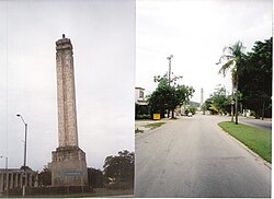
"El Obelisco", Carlos J. Finlay Memorial
Havana Map - Marianao.png
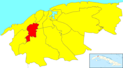
Location of Marianao in Havana
Coordinates: 23°05′0″N82°26′0″W / 23.08333°N 82.43333°W / 23.08333; -82.43333
CountryFlag of Cuba.svg Cuba
Province Coat of arms of La Habana.svg La Habana
Wards (Consejos Populares) CAI-Los Ángeles, Libertad, Pocito-Palmas, Pogoloti-Belén-Finlay, Santa Felicia, Zamora-Cocosolo
Area
[1]
  Total
22 km2 (8.5 sq mi)
Population
 (2022)
  Total
134,057
  Density6,100/km2 (16,000/sq mi)
Time zone UTC-5 (EST)
Area code +53-7

Marianao is one of the 15 municipalities or boroughs ( municipios in Spanish) in the city of Havana, Cuba. It lies 6 miles southwest of the original city of Havana, with which it is connected by the Marianao railway. In 2022 the municipality had a population of 134,057. [2] Marianao is on a range of hills of about 1500 above sea level and is noted for its salubrious climate. [3] The city dates back to 1830.

Contents

Overview

As Havana expanded during the 1930s and 1940s, Marianao became a suburb of the city.

A famous landmark is the monument built to honor Carlos Juan Finlay, a doctor who helped eradicate yellow fever in Cuba in the 19th century. It is shaped like a syringe. The monument is at the junction of Calles 100 and 31, close to several major hospitals.[ citation needed ]

Marianao is home to the famous Tropicana Club and was home to the Oriental Park Racetrack. One of the most notable foods made in Marianao is "Pollo A La Barbacoa".

Personalities

Twin towns

References

  1. Statoids (July 2003). "Municipios of Cuba" . Retrieved 2007-10-06.
  2. "Cuba: Administrative Division (Provinces and Municipalities) - Population Statistics, Charts and Map". www.citypopulation.de. Retrieved 2024-02-03.
  3. Encyclopædia Britannica
  4. "Relaciones Internacionales | Gobierno Municipal de Zapopan 2010 - 2011". www.zapopan.gob.mx. Archived from the original on 2011-09-25.
  5. Asuntos Internacionales y Ciudades Hermanas