La Habana Province[la aˈβana](listen), formerly known as Ciudad de La Habana Province, is a province of Cuba that includes the territory of the city of Havana, the Republic's capital. Between 1878 and 2010, the name referred to another province that covered a much larger area, which in 2010 was subdivided into the present-day provinces of Artemisa and Mayabeque.

Cienfuegos is one of the provinces of Cuba. The capital city of the province is also called Cienfuegos and was founded by French settlers in 1819.

Las Tunas is one of the provinces of Cuba. Major towns include Puerto Padre, Amancio, and the capital city, Las Tunas.
Ciego de Ávila is a city in the central part of Cuba and the capital of Ciego de Ávila Province. The city has a population of about 156,322 and the province 430,616.

Regla is one of the 15 municipalities or boroughs in the city of Havana, Cuba. It comprises the town of Regla, located at the bottom of Havana Bay in a former aborigine settlement named Guaicanamar, Loma Modelo in a peninsula dividing Marimelena from Guasabacoa inlets, and the village of Casablanca located at the entry of the Havana Bay.

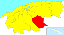
San Miguel del Padrón is one of the 15 municipalities/boroughs into which the city of Havana, Cuba is divided. It is on Havana's south-eastern outskirts, stretching from Ciudad Mar to Diezmero and from Reparto Mañana to Caballo Blanco.

Marianao is one of the 15 municipalities or boroughs in the city of Havana, Cuba. It lies 6 miles southwest of the original city of Havana, with which it is connected by the Marianao railway. In 1989 the municipality had a population of 133,016. Marianao is on a range of hills of about 1500 above sea level and is noted for its salubrious climate. The city dates back to 1830.

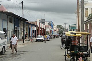
Las Tunas is a city and municipality in central-eastern Cuba. It is the capital of the Las Tunas Province and was named Victoria de Las Tunas from 1869 to 1976.

Playa is a Cuban municipality, located in the Havana province. It covers an area of 36.8 square kilometers, which makes up 8.95% of the provincial extension.
Habana del Este, also spelled La Habana del Este, is one of the 15 municipalities or boroughs forming the city of Havana, Cuba.

Boyeros is one of the 15 municipalities or boroughs in the city of Havana, Cuba. The municipality was created in 1976, and amalgamated the town of Santiago de Las Vegas. It lies on the south-west side of the city and includes José Martí International Airport.

Centro Habana is one of the 15 municipalities or boroughs in the city of Havana, Cuba. There are many retail spaces (such as Plaza de Carlos III commercial center, office buildings, hotels, bars and clubs. A chinatown - Barrio Chino - is also located in this district. It is a smaller municipality of Havana, and it has the highest population density.

Arroyo Naranjo is one of the 15 municipalities or boroughs in the city of Havana, Cuba. It became part of Havana city while the capital grew.

Cerro is one of the 15 municipalities or boroughs in the city of Havana, Cuba. As of 2016 it is considered "one of Havana’s poorest municipalities."

La Lisa is one of the 15 municipalities or boroughs in the city of Havana, Cuba.

Diez de Octubre is one of the 15 municipalities or boroughs in the city of Havana, Cuba.
The provinces of Cuba are divided into 168 municipalities or municipios. They were defined by Cuban Law Number 1304 of July 3, 1976 and reformed in 2010 with the abrogation of the municipality of Varadero and the creation of two new provinces: Artemisa and Mayabeque in place of former La Habana Province.

Caimito is a municipality and town in Artemisa Province of Cuba. The town was founded in 1820. The municipality of Caimito del Guayabal was created in 1910, based on the previously existing (1879–1902) municipality of Guayabal in the Pinar del Río Province. Since 1976, the official name is Caimito.

San José de las Lajas is a municipality and the capital city of the newly formed Mayabeque Province of Cuba, after the segmentation of La Habana Province in 2011. It is located in the center north of the province, and is bisected by the Carretera Central.

Carlos Manuel de Céspedes, also shortened as Céspedes, is a town and municipality in the Camagüey Province of Cuba. It was named for the independence fighter Carlos Manuel de Céspedes (1819-1874).