Manajanabo

Last updated
Manajanabo
Town [1]
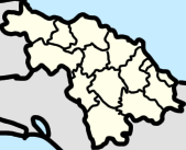
Villa Clara Map - Manajanabo (Santa Clara).png
Manajanabo (red) in Santa Clara (orange) in Villa Clara (yellow)
Cuba (location map).svg
Red pog.svg
Manajanabo
Villa Clara Province location map.png
Red pog.svg
Manajanabo
Santa Clara (Cuba) location map.png
Red pog.svg
Manajanabo
Coordinates: 22°23′02″N79°49′01″W / 22.3839738°N 79.8169152°W / 22.3839738; -79.8169152
Country Cuba
Province Villa Clara
Municipality Santa Clara
Area
[2]
  Total
0.452 km2 (0.175 sq mi)
Population
 (2012) [2]
  Total
1,750
  Density3,870/km2 (10,000/sq mi)
Postal Code
50100 [3]
 

Manajanabo is a town and ward ( consejo popular ) in Santa Clara, Cuba. Manajanabo lies on the Minerva Lake.

Contents

Geography

Manajanabo ward borders Sakenaf, Escambray, Vigía Sandino, Universidad, and Camilo Cienfuegos. [4]

Notable people

References

  1. "Manajanabo, Villa Clara, Cuba". cu.geoview.info.
  2. 1 2 "Santa Clara (Municipality, Villa Clara Province, Cuba) - Population Statistics, Charts, Map and Location". www.citypopulation.de.
  3. "Manajanabo Villa Clara Postal / ZIP codes and streets list - Getpostalcodes.com". www.getpostalcodes.com.
  4. "EVALUACIÓN GEOAMBIENTAL DE LA CIUDAD Y EL MUNICIPIO DE SANTA CLARA, CUBA, PARA EL PERFECCIONAMIENTO DEL SISTEMA DE VIGILANCIA EN SALUD - PDF Descargar libre". docplayer.es. Retrieved 2022-09-11.