Matanzas is one of the provinces of Cuba. Major towns in the province include Cárdenas, Colón, Jovellanos and the capital of the same name, Matanzas. The resort town of Varadero is also located in this province.

Ciego de Ávila is a city in the central part of Cuba and the capital of Ciego de Ávila Province. The capital city has a population of about 156,322 and the province 430,507.

Florida is a municipality and city in the Camagüey Province of Cuba. It is located 40 km (25 mi) north-west of Camagüey, along the Carretera Central highway. The city was established in 1907, and the municipality was established in 1924. Of all the municipalities of the Cuban province of Camagüey, Florida is third in area size. The name is Spanish for Land of flowers.

Campechuela is a municipality and town in Granma Province of Cuba. It is located on the southern shore of the Gulf of Guacanayabo.

Antilla is a municipality in Holguín Province of Cuba. It was founded in January 21, 1925 as a railroad terminal and port town.

Aguada de Pasajeros is a municipality and town in the Cienfuegos Province of Cuba.

Rodas is a municipality and town in the Cienfuegos Province of Cuba. It was founded in 1859 under the name of Lechuzo. In 1879 it was renamed Rodas in honour of capitán general Caballero de Rodas.
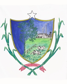
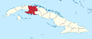
Los Arabos is a municipality and town in the Matanzas Province of Cuba. It is located in the eastern part of the province, bordering the province of Villa Clara.

Unión de Reyes is a municipality and town in the Matanzas Province of Cuba. It is located in the western part of the province, 30 kilometres (19 mi) south of Matanzas, the provincial capital.

Lajas, known historically and culturally as Santa Isabel de las Lajas, is a municipality and town in the Cienfuegos Province of Cuba. It is located in the northern part of the province, 35 kilometres (22 mi) west of Santa Clara and immediately south of the A1 motorway.
Mella is a town and municipality in the Santiago de Cuba Province of Cuba. It is located 20 km (12 mi) north of Palma Soriano and was named after the Cuban revolutionary and communist Julio Antonio Mella.

Carlos Manuel de Céspedes, also shortened as Céspedes, is a town and municipality in the Camagüey Province of Cuba. It was named for the independence fighter Carlos Manuel de Céspedes (1819-1874).

Majagua is a municipality and town in the Ciego de Ávila Province of Cuba. It is located in the eastern part of the province, and is bisected by the Carretera Central highway.

Maisí is a municipality and town in the Guantánamo Province of Cuba. Its administrative seat is located in the town of La Máquina.

El Salvador is a municipality and town in the Guantánamo Province of Cuba. It is located immediately north of the provincial capital, Guantánamo.

Manuel Tames is a municipality and town in the Guantánamo Province of Cuba. Its administrative seat is located in the town of Jamaica.

Báguanos is a municipality and town in the Holguín Province of Cuba.
Pilón is a municipality and town in the Granma Province of Cuba. It is located on the southern coast of Cuba, in an inlet of the Caribbean Sea.

Media Luna is a town and municipality in the Granma Province of Cuba. It is located on the coastal region of the province, bordering the Gulf of Guacanayabo, between Niquero and Campechuela.

Primero de Enero is a municipality and town in the Ciego de Ávila Province, Cuba. Originally named Violeta,¿ its name means "1st of January" in Spanish, and is referred to the final day of the Cuban Revolution.

