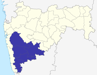
Pune Division is one of the six administrative divisions of the Indian State of Maharashtra. Pune Division is bound by Konkan Division to the west, Nashik Division to the north, Aurangabad Division to the east, and the state of Karnataka to the south.

Sangli district is a district of Maharashtra state in India. Sangli city is the district headquarters. It is bordered by Satara district, Solapur district to the North, Karnataka state to the South-East, by Kolhapur district to South-West and by narrow portion on the East side to Ratnagiri district. It is present on the southern tip of Maharashtra.

Solapur District is a district in Maharashtra state of India. The city of Solapur is the district headquarters. It is located on the south east edge of the state and lies entirely in the Bhima and Seena basins. The entire district is drained by the Bhima River.

Daund taluka is a taluka or subdivision of Pune district of the state of Maharashtra in India. The town of Daund is the only major urban area in this predominantly rural area. Daund railway station is a major railway junction. All southern railways are connected to this route, and also divided the Nagar railway to north Indian railway, like Delhi, Solapur division, Daund junction and then joined to the Pune district junction. To reach the Siddhi Vinayak Siddhatek Ganpati temple, one has to travel 14 km to Daund by road.
Ramwadi is a village in the Karmala taluka of Solapur district in Maharashtra state, India.
Hingani is a village in the Karmala taluka of Solapur district in Maharashtra state, India.
Bhagatwadi is a village in the Karmala taluka of Solapur district in the Indian state of Maharashtra. The village is situated behind Ujjani Dam. The main occupation is sugarcane cultivation.
Maroli is a village in the Mangalvedha taluka of Solapur district in Maharashtra state, India.
Bhalwani is a village in the Mangalvedha taluka of Solapur district in Maharashtra state, India.
Vanjanwadi is a village in the Karmala taluka of Solapur district in Maharashtra state, India.
Limbewadi is a village in the Karmala taluka of Solapur district in Maharashtra state, India. This village is on the border of Solapur and Ahmednagar district in Maharashtra state. This village has ISO certified Z.P. Primary school up to 4th standard. Agriculture is the main profession of this village.
Rajuri is a village in the Karmala taluka of Solapur district in Maharashtra state, India.
Anjandoh is a village in the Karmala taluka of Solapur district in Maharashtra state, India.
Khadaki is a village in the Karmala taluka of Solapur district in Maharashtra state, India.
Padali is a village in the Karmala taluka of Solapur district in Maharashtra state, India.
Pothare is a village in the Karmala taluka of Solapur district in Maharashtra state, India.
Salse is a village in the Karmala taluka of Solapur district in Maharashtra state, India.
Shelgaon (K) is a village in the Karmala taluka of Solapur district in Maharashtra state, India.
Kugaon is a village in the Karmala taluka of Solapur district in Maharashtra state, India.
Dahigaon is a village in the Karmala taluka of Solapur district in Maharashtra state, India.

