Mexican cuisine consists of the cooking cuisines and traditions of the modern country of Mexico. Its earliest roots lie in Mesoamerican cuisine. Its ingredients and methods begin with the first agricultural communities such as the Olmec and Maya who domesticated maize, created the standard process of nixtamalization, and established their foodways. Successive waves of other Mesoamerican groups brought with them their cooking methods. These included: the Teotihuacanos, Toltec, Huastec, Zapotec, Mixtec, Otomi, Purépecha, Totonac, Mazatec, Mazahua, and Nahua. With the Mexica formation of the multi-ethnic Triple Alliance, culinary foodways became infused.

Michoacán, formally Michoacán de Ocampo, officially the Estado Libre y Soberano de Michoacán de Ocampo, is one of the 31 states which, together with Mexico City, comprise the Federal Entities of Mexico. The state is divided into 113 municipalities and its capital city is Morelia. The city was named after José María Morelos, a native of the city and one of the main heroes of the Mexican War of Independence.

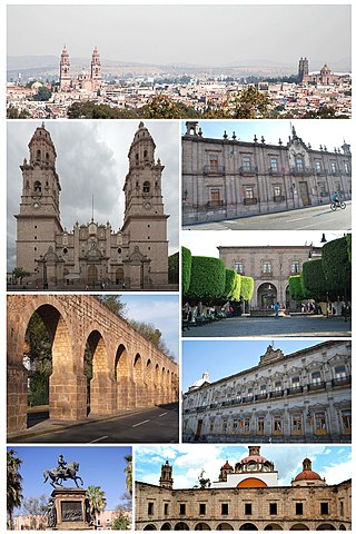
Morelia is a city and municipal seat of the municipality of Morelia in the north-central part of the state of Michoacán in central Mexico. The city is in the Guayangareo Valley and is the capital and largest city of the state. The main pre-Hispanic cultures here were the Purépecha and the Matlatzinca, but no major cities were founded in the valley during this time. The Spanish took control of the area in the 1520s. The Spanish under Viceroy Antonio de Mendoza founded a settlement here in 1541 with the name of Valladolid, which became rival to the nearby city of Pátzcuaro for dominance in Michoacán. In 1580, this rivalry ended in Valladolid's favor, and it became the capital of the viceregal province. After the Mexican War of Independence, the city was renamed Morelia in honor of José María Morelos, who hailed from the city. In 1991, the city was declared a UNESCO World Heritage Site for its well-preserved historical buildings and layout of the historic center. It is tradition to name people born on September 30 after the city.

Michoacán is a state in western Mexico that is divided into 113 municipalities. According to the 2020 Mexican census, it is the ninth most populated state with 4,748,846 inhabitants and the 16th largest by land area spanning 58,598.7 square kilometres (22,625.1 sq mi).

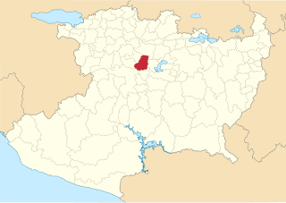
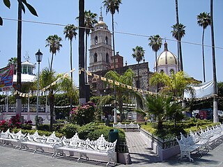
Tangancícuaro is a municipio (municipality) in the Mexican state of Michoacán, western Mexico.
Los Reyes is a municipality in the western part of the Mexican state of Michoacán. The municipality has an area of 480.09 square kilometres and is bordered to the north by the municipality of Tangancícuaro, to the east by Charapan, to the southeast by Uruapan, to the south by Peribán, to the southwest by Tocumbo, and to the northwest by Tingüindín. The municipality had a population of 77,000 inhabitants according to the 2009 census. Its municipal seat is the city of Los Reyes de Salgado.The city is also known for exporting avocados and blackberries. Both of these orchids surround the area between Los Reyes and Periban, it is also home of the Lobos Grises de los Reyes a professional soccer team currently playing in the Tercera Division Mexicana at Group IX.

Angangueo is a municipality located in far eastern Michoacán state in central Mexico noted for its history of mining and its location in the Monarch Butterfly Biosphere Reserve. The municipal seat is the Mineral de Angangueo. It is located in high rugged forested mountains, with the town in a small canyon.

Mazamitla is a town and municipality of the Mexican state of Jalisco. It is located 124 km south of Guadalajara in the Southeast Region and is a popular resort destination for travelers from Guadalajara and nearby urban centers. Its name comes from the Nahuatl and means "place where arrows are made to hunt deer"; its area is 288.9 km2. According to Count II Population and Housing, the municipality has 11671 inhabitants who are devoted mainly to the tertiary sector. For its natural environment is considered by the federal Secretariat of Tourism as a Pueblo Mágico.

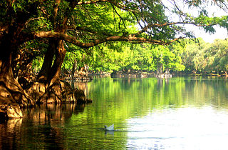
Huandacareo is an archaeological zone located about 60 kilometers north of the city of Morelia, in the state of Michoacán.

Michoacán handcrafts and folk art is a Mexican regional tradition centered in the state of Michoacán, in central/western Mexico. Its origins traced back to the Purépecha Empire, and later to the efforts to organize and promote trades and crafts by Vasco de Quiroga in what is now the north and northeast of the state. The state has a wide variety of over thirty crafts, with the most important being the working of wood, ceramics, and textiles. A number are more particular to the state, such as the creation of religious images from corn stalk paste, and a type of mosaic made from dyed wheat straw on a waxed board. Though there is support for artisans in the way of contests, fairs, and collective trademarks for certain wares, Michoacán handcrafts lack access to markets, especially those catering to tourists.
Ziracuaretiro is a municipality in the Mexican state of Michoacán.
Zináparo is a municipality in the Mexican state of Michoacán.
Villamar is a municipality in the Mexican state of Michoacán.
Ixtlán is a municipality in the Mexican state of Michoacán.
XHTGAN-FM is a community radio station on 107.1 FM in Tangancícuaro, Michoacán, Mexico. It is known as Radio Erandi.

Purépero de Echaíz is a town in the northwest of the state of Michoacán in Mexico and head of the municipality of Purépero. Purépero is located in the middle of the Tarascan Plateau. Purépero is 113 km from the state capital of Morelia and is bordered to the north by Tlazazalca, to the east by Zacapu, to the south by Chilchota, and to the west by Tangancícuaro.

Nahuatzen is a municipality in the Mexican state of Michoacán, located approximately 75 kilometres (47 mi) west of the state capital of Morelia.

Senguio is a municipality in the Mexican state of Michoacán, located approximately 90 kilometres (56 mi) east of the state capital of Morelia.

Tanhuato is a municipality in the Mexican state of Michoacán, located approximately 135 kilometres (84 mi) northwest of the state capital of Morelia.


