
Alexander Island, which is also known as Alexander I Island, Alexander I Land, Alexander Land, Alexander I Archipelago, and Zemlja Alexandra I, is the largest island of Antarctica. It lies in the Bellingshausen Sea west of Palmer Land, Antarctic Peninsula from which it is separated by Marguerite Bay and George VI Sound. George VI Ice Shelf entirely fills George VI Sound and connects Alexander Island to Palmer Land. The island partly surrounds Wilkins Sound, which lies to its west. Alexander Island is about 390 kilometres (240 mi) long in a north-south direction, 80 kilometres (50 mi) wide in the north, and 240 kilometres (150 mi) wide in the south. Alexander Island is the second largest uninhabited island in the world, after Devon Island.
The Prince Albert Mountains are a major mountain group in Antarctica over 320 km (200 mi) long. Located in Victoria Land, they run north-south between the Priestley and Ferrar glaicers.
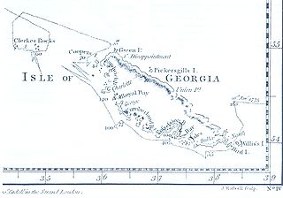
The Clerke Rocks are a group of small rocky islands some 35 miles (56 km) southeast of South Georgia that extend 5 miles (8.0 km) from east to west. The Clerke Rocks include The Office Boys at the northeastern end and Nobby at the southeastern end of the group. The islands belong to the British Overseas Territory of South Georgia and the South Sandwich Islands and are also claimed by Argentina as part of Tierra del Fuego Province.
The Humboldt Mountains are a group of mountains immediately west of the Petermann Ranges, forming the westernmost portion of the Wohlthat Mountains in Queen Maud Land, Antarctica.

The Dion Islands are a group of small islands and rocks lying in the northern part of Marguerite Bay, 11 kilometres (6 nmi) south-west of Cape Alexandra, Adelaide Island, off the west coast of the Antarctic Peninsula. They were discovered by the French Antarctic Expedition, 1908–10, and named by Jean-Baptiste Charcot for the Marquis Jules-Albert de Dion, who donated three motor sledges and whose De Dion-Bouton works produced equipment for the expedition.

Makresh Rocks are a group of rocks situated 1.8 km (1.12 mi) northeast of Treklyano Island off the northeast coast of Robert Island, South Shetland Islands. Extending 600 m (656 yd) in west-southwest to east-northeast direction, and 270 m (295 yd) in northwest-southeast direction. The solitary Salient Rock62°21′24″S59°20′59″W is lying 1.73 km (1.07 mi) east of the midpoint of Makresh Rocks and 2 km (1.24 mi) northeast of Smirnenski Point.

MV Nella Dan was one of the famous 'Dan' ships of the Danish J. Lauritzen A/S Lines that were almost synonymous with ANARE shipping through the early years of Australia's official Antarctic program. Others in the fleet included Kista Dan, Magga Dan and Thala Dan.
Walkabout Rocks is a prominent rock exposure along the coast at the north-eastern extremity of the Vestfold Hills, about 0.5 nautical miles south of the Wyatt Earp Islands of Princess Elizabeth Land, Antarctica. It was mapped from aerial photographs taken by the Lars Christensen Expedition, 1936-37.
The Tryne Islands are a group of numerous small Antarctic islands and rocks, about 7 km (4 mi) in extent, forming the western limit of Tryne Bay and Tryne Sound at the north-eastern end of the Vestfold Hills. The islands were mapped by Norwegian cartographers from aerial photographs taken by the Lars Christensen Expedition (1936–37) and named Trynøyane.
Lientur Rocks is a group of prominent adjacent rocks lying off the north coast of Robert Island in the South Shetland Islands, Antarctica and extending 660 m (722 yd) in east-west direction and 320 m (350 yd) in north-south direction. The area was visited by early 19th-century sealers operating from nearby Clothier Harbour.
The Östliche Petermann Range is one of the Petermann Ranges, trending in a north-south direction for 15 nautical miles (28 km) from Per Spur to the Gornyye Inzhenery Rocks, in the Wohlthat Mountains of Queen Maud Land. It was discovered and plotted from air photos by German Antarctic Expedition of 1938–39, and so named by them for its eastern location in the Petermann Ranges.
The Departure Rocks are a group of 4 steep-sided rocks lying 2 kilometres (1 nmi) north of Peake-Jones Rock in Holme Bay, Mac. Robertson Land. They were mapped by Norwegian cartographers from air photos taken by the Lars Christensen Expedition, 1936–37, and were so named by the Antarctic Names Committee of Australia because Australian National Antarctic Research Expeditions parties going west from Mawson Station on the sea ice always pass through or close to these rocks.
The Douglas Islands are two small islands 22 kilometres (12 nmi) northwest of Cape Daly, and 6 kilometres (3 nmi) north of Andersen Island, as well as 7 kilometres (4 nmi) north-east of Child Rocks, which are both part of the Robinson Group.. They were discovered by the British Australian New Zealand Antarctic Research Expedition under Mawson, 1929–31, and named for Vice-Admiral Percy Douglas, then Hydrographer of the Royal Navy. The islands were first sighted during an aircraft flight from the Discovery on Dec. 3 1, 1929, and reported to lie in about 66°40′S64°30′E, but after the 1931 voyage they were placed at 67°20′S63°32′E. In 1956, an Australian National Antarctic Research Expeditions sledge party led by P.W. Crohn was unable to find them in this position, but found two uncharted islands farther south to which the name has now been applied.
The Moss Islands are a group of small islands and rocks lying east of Midas Island and north of Apéndice Island in Hughes Bay, off the west coast of Graham Land, Antarctica. They were first charted in detail and given the descriptive name "Moos Inseln" by the Swedish Antarctic Expedition under Otto Nordenskiöld in 1902.
The Hansen Rocks are a group of five small islands lying just north of Holme Bay and the coast of Mac. Robertson Land, Antarctica, about 2 kilometres (1 nmi) northeast of the Sawert Rocks and Nella Rock, and about 2 kilometres (1 nmi) northwest of the Canopus Rocks. They were plotted from Australian National Antarctic Research Expeditions (ANARE) air photographs, and were named by the Antarctic Names Committee of Australia for Captain B.T. Hansen, master of the Nella Dan for ANARE relief voyages in 1968, 1969, 1970 and 1972.
Kitney Island is a small island 2 kilometres (1 nmi) east-northeast of the Smith Rocks, 2 kilometres (1 nmi) southwest of the Wiltshire Rocks, and 5 kilometres (2.5 nmi) northwest of the Paterson Islands, off the coast of Mac. Robertson Land, Antarctica. The Lars Christensen Expedition (1936) first mapped this island which, though left unnamed, was included in a small group named by them "Spjotoyskjera". It was remapped by the Australian National Antarctic Research Expedition (ANARE) in 1956, and was named by the Antarctic Names Committee of Australia for V.J. Kitney, a supervising technician (radio) at Mawson Station in 1968.
Smith Rocks is a group of rocks lying 1 kilometre (0.5 nmi) northeast of Canopus Islands, 1 kilometre (0.5 nmi) west of Kitney Island, 3.7 kilometres (2 nmi) southwest of Wiltshire Rocks, and 5.6 kilometres (3 nmi) northwest of Paterson Islands, in the east part of Holme Bay, Mac. Robertson Land. Mapped by Norwegian cartographers from air photos taken by the Lars Christensen Expedition, 1936–37, and named Spjotoyholmane. Renamed by Antarctic Names Committee of Australia (ANCA) for Captain V. Smith, RAASC, DUKW driver who took part in ANARE changeover operations at Davis and Mawson stations in 1958-59 and 1959-60.

