This article needs additional citations for verification .(September 2016) |
Chilecito | |
---|---|
Coordinates: 29°10′S67°30′W / 29.167°S 67.500°W | |
Country | Argentina |
Province | La Rioja |
Department | Chilecito |
Founded | 1715 |
Government | |
• Mayor | Loro Waidatt (Juntos por el Cambio) |
Elevation | 1,080 m (3,540 ft) |
Population (2010 census) | |
• Total | 33,724 |
Demonym | chileciteña/o |
Time zone | UTC-3 (ART) |
CPA base | F5360 |
Area code | 03825 |
Climate | BWk |
Chilecito is a city in the Argentine province of La Rioja, and head of the department of Chilecito.
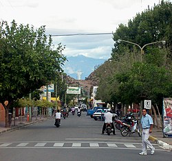
The city is located in the valley formed by the Sierras de Velazco to the east, and the Sierras de Famatina to the west. The city was founded in 1715 by Spanish colonizers. Chilecito still preserves the cable-car of La Mejicana mine built by Bleichert which is part of the city mining past that saw its peak at the end of the 19th century.
Chilecito is surrounded by an oasis of irrigation, which has been expanded by way of supplements from underground waters. A great part of agricultural land is used for the cultivation of vineyards because the most significant industrial activity is based in wine-cellars. Walnut and fruit trees are also cultivated and their product is locally processed.
The Argentine educator, lawyer, senator, governor and historian Joaquín V. González was raised in the vicinity of Chilecito. He also used to spend his vacation in a home that he built here in his later years. The property, which he called Samay Huasi (Quechua Samay Wasi, "rest house") was donated to the University of La Plata for use as an artists' retreat.
By the end of the 1990s, the university of Chilecito which was still part of the National University of La Rioja became the National University of Chilecito. This decision was highly criticized by different academic and political sectors, especially those concerning to the President of Argentina at the time, Carlos Menem.
According to statistics, Chilecito had 49,453 inhabitants (data taken from the 2010 census [INDEC]) which represents a 31% population increase in ten years (there were 22,485 inhabitants in 1991). These numbers include the nearby localities of Anguinán, Los Sarmientos, San Miguel and La Puntilla; without them, the population of Chilecito in 2001 was 25,423 inhabitants.
Climate data for Chilecito (1991–2000, extremes 1961–present) | |||||||||||||
---|---|---|---|---|---|---|---|---|---|---|---|---|---|
Month | Jan | Feb | Mar | Apr | May | Jun | Jul | Aug | Sep | Oct | Nov | Dec | Year |
Record high °C (°F) | 43.1 (109.6) | 42.0 (107.6) | 40.5 (104.9) | 38.5 (101.3) | 38.2 (100.8) | 45.4 (113.7) | 35.3 (95.5) | 38.5 (101.3) | 40.0 (104.0) | 41.5 (106.7) | 43.7 (110.7) | 44.3 (111.7) | 45.4 (113.7) |
Mean daily maximum °C (°F) | 32.9 (91.2) | 31.1 (88.0) | 29.6 (85.3) | 25.3 (77.5) | 21.2 (70.2) | 17.6 (63.7) | 17.2 (63.0) | 21.4 (70.5) | 24.6 (76.3) | 28.1 (82.6) | 31.1 (88.0) | 33.8 (92.8) | 26.2 (79.2) |
Daily mean °C (°F) | 24.9 (76.8) | 23.5 (74.3) | 22.3 (72.1) | 17.8 (64.0) | 13.9 (57.0) | 10.2 (50.4) | 9.1 (48.4) | 12.8 (55.0) | 16.5 (61.7) | 20.2 (68.4) | 22.6 (72.7) | 25.7 (78.3) | 18.3 (64.9) |
Mean daily minimum °C (°F) | 18.7 (65.7) | 16.9 (62.4) | 16.3 (61.3) | 11.1 (52.0) | 7.1 (44.8) | 2.5 (36.5) | 0.6 (33.1) | 3.6 (38.5) | 7.3 (45.1) | 11.9 (53.4) | 15.5 (59.9) | 18.4 (65.1) | 10.9 (51.6) |
Record low °C (°F) | 9.3 (48.7) | 8.5 (47.3) | 2.4 (36.3) | 0.4 (32.7) | −5.1 (22.8) | −7.7 (18.1) | −7.7 (18.1) | −6.9 (19.6) | −5.4 (22.3) | −2.0 (28.4) | 1.3 (34.3) | 6.8 (44.2) | −7.7 (18.1) |
Average precipitation mm (inches) | 51.1 (2.01) | 35.5 (1.40) | 16.4 (0.65) | 7.4 (0.29) | 5.2 (0.20) | 1.7 (0.07) | 2.4 (0.09) | 2.4 (0.09) | 4.4 (0.17) | 6.1 (0.24) | 7.9 (0.31) | 23.7 (0.93) | 162.5 (6.40) |
Average precipitation days (≥ 0.1 mm) | 4.3 | 4.6 | 2.6 | 1.8 | 0.8 | 0.9 | 1.0 | 0.5 | 1.3 | 1.3 | 1.4 | 3.8 | 23.5 |
Average snowy days | 0.0 | 0.0 | 0.0 | 0.0 | 0.0 | 0.1 | 0.1 | 0.1 | 0.0 | 0.0 | 0.0 | 0.0 | 0.3 |
Average relative humidity (%) | 58.4 | 60.7 | 64.3 | 64.7 | 65.8 | 67.2 | 63.3 | 55.7 | 53.4 | 51.7 | 52.3 | 53.2 | 59.6 |
Mean monthly sunshine hours | 272.8 | 223.2 | 198.4 | 195.0 | 195.3 | 171.0 | 220.1 | 238.7 | 231.0 | 248.0 | 279.0 | 291.4 | 2,763.9 |
Percent possible sunshine | 64.3 | 60.4 | 53.0 | 57.9 | 59.6 | 56.6 | 68.4 | 69.9 | 64.4 | 62.6 | 68.8 | 67.8 | 62.5 |
Source: Servicio Meteorológico Nacional [1] [2] |
La Rioja ,spanish local pronunciation, is the capital and largest city of La Rioja Province, Argentina, located in the east of the province.
San Fernando del Valle de Catamarca is the capital and largest city in Catamarca Province in northwestern Argentina, on the Río Valle River, at the feet of the Cerro Ambato. The city name is normally shortened as Catamarca.
Rawson is the capital of the Argentine province of Chubut, in Patagonia. It has 24,616 inhabitants in 2010, and it is the chief town of the Rawson Department.
Santa Rosa is a city in the Argentine Pampas (lowlands), and the capital of La Pampa Province, Argentina. It lies on the east of the province, on the shore of the Don Tomás Lagoon, at the intersection of National Routes 5 and 35. The city (94,340) and its surroundings hold 102,610 inhabitants ,Census-ar 2.010 hold 124.101 inhabitants the capital y Toay around a third of the population of the province. Its current mayor is Luciano di Nápoli. Founded in 1892 by Tomás Mason, Santa Rosa did not develop into a relatively important agricultural centre until the second half of the 20th century. It is still one of the smallest provincial capitals of the country after Patagonian Rawson, Ushuaia and Viedma.
Tandil is the main city of the homonymous partido (department), located in Argentina, in the southeast of Buenos Aires Province, just north-northwest of Tandilia hills. The city was founded in 1823 and its name originates from the Piedra Movediza which fell in 1912. The city is the birthplace of many notable sports personalities, as well as former president of Argentina Mauricio Macri.
San Antonio de Padua de la Concordia is a city in the north-east of the province of Entre Ríos in the Argentine Mesopotamia. It had about 149,450 inhabitants at the 2010 census [INDEC], and is the head town of the department of the same name.
Ezeiza is the capital city of the Ezeiza Partido within the Greater Buenos Aires area in Argentina. The city had a population of 160,219 in 2010. Ezeiza is one of the fastest-growing cities in Argentina; the city and its surroundings are known for the many gated communities there, as well as for the Ministro Pistarini International Airport and the Ezeiza Federal Prison Complex. Ezeiza and its surrounds are known as affluent areas.
Río Cuarto is a city in the province of Córdoba, Argentina. Located in the south of the province, it has about 157,000 inhabitants and is an important commercial and agricultural hub.
San Luis is the capital city of San Luis Province in the Cuyo region of Argentina. It is also the seat of the Juan Martín de Pueyrredón Department.
Posadas is the capital city of the Argentine province of Misiones, in its south, at the far north-west of the country on the left bank of the Paraná River, opposite Encarnación, Paraguay. The city has an area of 965 square kilometres (373 sq mi) and a population of 324,756, and the Greater Posadas area has a population of over 359,609 according to a 2017 estimate.
Paso de los Libres is a city in the east of the province of Corrientes in the Argentine Mesopotamia. It had about 44,000 inhabitants at the 2010 census [INDEC], and is the head town of the department of the same name.
Tinogasta is a city in the west of the province of Catamarca, Argentina, on the right-hand shore of the Abaucán River, about 280 km from the provincial capital San Fernando del Valle de Catamarca. It had about 11,500 inhabitants at the 2010 census [INDEC]. It is the head town of the department of the same name. The name of the city comes from the Kakana words tino ("meeting") and gasta ("town").
Laboulaye is a city in the southeast of the province of Córdoba, Argentina. It has 20,534 inhabitants as per the 2010 census [INDEC]. It lies on National Route 7, near the provincial borders of Santa Fe and Buenos Aires, about 315 km south from Córdoba City and 285 km west from Rosario.
Bernardo de Irigoyen is a city in the province of Misiones, Argentina. It has 10,889 inhabitants as per the 2001 census [INDEC], and is the head town of the General Manuel Belgrano Department. It carries the name of prominent politician and diplomat Bernardo de Irigoyen.
San Miguel is a city in the northwest region of Greater Buenos Aires, 30 km from the City of Buenos Aires. San Miguel is the county seat of San Miguel Partido, and has been a part of Greater Buenos Aires since the early 2000s. The number of inhabitants was 157,532 according to the 2001 census.
San Martín is a city in the north-center part of the Mendoza Province in Argentina. It is the capital of the San Martín Department and constitutes, with Palmira and La Colonia, the third-largest metropolitan area in the province.
Villa Dolores is a city in the province of Córdoba, Argentina, located in the southwestern side of the province. It has a population of 29,854 inhabitants.
Chamical is a small city in, and the seat of government of, Chamical Department in the south of La Rioja Province of Argentina. With a population of 12,919 permanent residents at the 2010 census [INDEC], up from 11,831 at the time of the 2001 census, it is the third-most populous settlement in La Rioja Province after Chilecito. It is home to the CELPA aerospace test center, founded in 1961 and operated by the Argentine Air Force. The town, which is crossed by the Tirante wadi, lies on the Ruta 38, around 140 km from La Rioja, and some 300 km from Córdoba.
Joaquín Víctor González was an Argentine educator, political scientist, writer, magistrate, and politician.
Samay Huasi is a historic property in Argentina functioning as both a vacation retreat, as well as a museum.