
Windhoek is the capital and largest city of Namibia. It is located in central Namibia in the Khomas Highland plateau area, at around 1,700 m (5,600 ft) above sea level, almost exactly at the country's geographical centre. The population of Windhoek, which was 486,169 in 2023, is constantly growing due to a continued migration from other regions in Namibia.

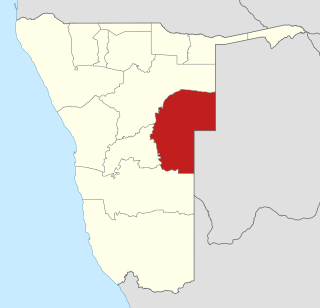
The Zambezi Region is one of Namibia's fourteen regions, situated in the north-eastern part of the country along the Zambezi River where it gets it's name from. The region's capital is the town of Katima Mulilo. The Katima Mulilo Airport is 18 kilometres south-west of the town, while the village of Bukalo is located 43 kilometres south-east of Katima Mulilo. Formerly known as the Caprivi Region until 2013, it has eight electoral constituencies and a population of 142,373 according to the 2023 census.

Oshikoto is one of the fourteen regions of Namibia, named after Lake Otjikoto. Its capital is Omuthiya. Further major settlements in the region are Tsumeb, Otjikoto's capital until 2008, and Oniipa. As of 2020, Oshikoto had 112,170 registered voters.
Omaheke is one of the fourteen regions of Namibia, the least populous region. Its capital is Gobabis. It lies in eastern Namibia on the border with Botswana and is the western extension of the Kalahari desert. The self-governed villages of Otjinene, Leonardville and Witvlei are situated in the region. As of 2020, Omaheke had 48,594 registered voters.

Kunene is one of the fourteen regions of Namibia. Its capital is Opuwo, its governor is Marius Sheya. The region's name comes from the Kunene River which forms the northern border with Angola. Besides the capital Opuwo, the region contains the municipality of Outjo, the town Khorixas and the self-governed village Kamanjab. Kunene is home to the Himba people, a subtribe of the Herero, as well as to Damara people and Nama people. As of 2020, Kunene had 58,548 registered voters.

Gobabis is a town in eastern Namibia. It is the regional capital of the Omaheke Region, and the district capital of the Gobabis electoral constituency. Gobabis is situated 200 km (120 mi) down the B6 motorway from Windhoek to Botswana. The town is 113 km (70 mi) from the Buitepos border post with Botswana, and serves as an important link to South Africa on the tarred Trans-Kalahari Highway. Gobabis is in the heart of the cattle farming area. In fact Gobabis is so proud of its cattle farming that a statue of a large Brahman bull with the inscription "Cattle Country" greets visitors to the town. Gobabis also has its own local airport.

Kongola Constituency is a constituency in Namibia's Zambezi Region, with the Kongola settlement serving as its administrative centre. Covering an area of 5,174 km², it is the largest constituency in the region by area. The constituency lies near the Kwando River. The name "Kongola" is derived from Silozi, meaning "to gather" or "to bring people together." As of 2023, Kongola has a population of 12,069, resulting in a population density of 2.33 per km².

Linyanti Constituency is located in Namibia's Zambezi Region. The constituency derives its name from the Linyanti River. It has a population of 10,425 and covers an area of 1,804 square kilometres, resulting in a population density of approximately 5.78 people per square kilometre.

Sibbinda Constituency is a constituency in Namibia's Zambezi Region, with its administrative centre located in the settlement of Sibbinda. As of 2023, it has a population of 17,126 residents.

Katima Mulilo or simply Katima is the capital of the Zambezi Region in Namibia. It had 46,401 inhabitants in 2023, and comprises two electoral constituencies, Katima Mulilo Rural and Katima Mulilo Urban. It is located on the B8 national road on the banks of the Zambezi River in the Caprivi Strip in lush riverine vegetation with tropical birds and monkeys. The town receives annual average rainfall of 654 millimetres (25.7 in).

Otjiwarongo is a city of 49,000 inhabitants in the Otjozondjupa Region of Namibia. It is the district capital of the Otjiwarongo electoral constituency and also the capital of Otjozondjupa.
Otjimbingwe is a settlement in the Erongo Region of central Namibia. Otjimbingwe has approximately 8,000 inhabitants and belongs to the Karibib electoral constituency.
The MaYeyi are Bantu-speaking people of north-western Botswana and north-eastern Namibia. The Yeyi immigrated to the area in the 18th century from the north, and lived in close cooperation with the San people, or Basarwa, in particular, the Xanikhwe who had lived in the area previously. They speak ShiYeyi, a language that was influenced by the San and exhibits the characteristic clicks.
Simataa Secondary School is a school in the Caprivi Region of Namibia. It is situated near the headquarters of the Mafwe traditional authority in Chinchimane, some 70 km south of Katima Mulilo. Patron of the school is Deputy Minister of Information and Communication Technology, Stanley Simataa.

Epukiro is a cluster of small settlements in the remote eastern part of the Omaheke Region of Namibia, situated about 120 kilometres (75 mi) northeast of the regional capital Gobabis. The centre of the populated area is the Catholic mission station. Epukiro had about 3,200 inhabitants in 1997, predominantly ethnic Tswana.

Aminuis is a cluster of small settlements in the remote eastern part of the Omaheke Region of Namibia, located about 500 km east of Windhoek. It is the district capital of the Aminuis electoral constituency.
Lusata Festival is an annual festival for all Mafwe tribal people of Namibia and nearby countries. The Mafwe people are one of the largest ethnic groups in the Caprivi Region. They speak ChiFwe. The festival celebrates traditional values, commemorates the past, and looks forward to the future. It occurs annually in the last week of September. The festival's name is a reference to the royal mace an ivory-encrusted stick.

Greater London is the administrative area of London, which is coterminous with the London region. It contains 33 local government districts: the 32 London boroughs, which form a ceremonial county also called Greater London, and the City of London. The Greater London Authority is responsible for strategic local government across the region, and regular local government is the responsibility of the borough councils and the City of London Corporation. Greater London is bordered by the ceremonial counties of Hertfordshire to the north, Essex to the north-east, Kent to the south-east, Surrey to the south, and Berkshire and Buckinghamshire to the west.

