| Chindio | |
|---|---|
| Village | |
 Chindio | |
| Coordinates: 18°04′S35°46′E / 18.067°S 35.767°E | |
| Country | |
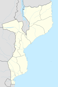
| Provinces | Zambezia Province |
| District | Morrumbala District |
| Elevation | 176 m (577 ft) |
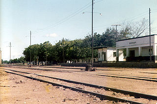
Chindio is a village on the north bank of the Zambezi River in Mozambique, downstream of its junction with the Shire River. Chindio is not the same place as Chinde, although they are both on the Zambezi and in Mozambique.

The Zambezi is the fourth-longest river in Africa, the longest east-flowing river in Africa and the largest flowing into the Indian Ocean from Africa. The area of its basin is 1,390,000 square kilometres (540,000 sq mi), slightly less than half of the Nile's. The 2,574-kilometre-long river (1,599 mi) rises in Zambia and flows through eastern Angola, along the north-eastern border of Namibia and the northern border of Botswana, then along the border between Zambia and Zimbabwe to Mozambique, where it crosses the country to empty into the Indian Ocean.

Mozambique, officially the Republic of Mozambique, is a country located in Southeast Africa bordered by the Indian Ocean to the east, Tanzania to the north, Malawi and Zambia to the northwest, Zimbabwe to the west, and Eswatini (Swaziland) and South Africa to the southwest. The sovereign state is separated from the Comoros, Mayotte and Madagascar by the Mozambique Channel to the east. The capital of Mozambique is Maputo while Matola is the largest city, being a suburb of Maputo.

The Shire is the largest river in Malawi. The river has been known as the Shiré or Chire River. It is the only outlet of Lake Malawi and flows into the Zambezi River in Mozambique. Its length is 402 kilometres (250 mi). The upper Shire River issues from Lake Malawi and runs approximately 12 miles before it enters shallow Lake Malombe. It then drains Lake Malombe and flows south through Liwonde National Park where large concentrations of hippopotamus are common along its shores. Between the towns of Matope and Chikwawa, the middle river drops approximately 1,300 feet through a series of falls and gorges. Two hydroelectric dams have been built along the Shire northwest of Blantyre.
Between 1908 and 1914, riverboat services ran from the terminus of the Shire Highlands Railway at Port Herald in Nyasaland, now Malawi to the British concession of Chinde at the mouth of the Zambezi in Mozambique, where passengers and goods were transferred to seagoing ships. This was the main route for goods and passengers to and from Nyasaland. However, as the Shire River was difficult to navigate in the dry season when water levels were low, the British South Africa Company built the Central African Railway, 61 miles long, from Port Herald to Chindio on the north bank of the Zambezi. This line was opened in 1914. [1] Between 1914 and 1922, the African Lakes Corporation and British Central Africa Company both ran steamer services from Chindio to Chinde in the dry season, but from Port Herald to Chinde when water levels were sufficient. In 1922, the Trans-Zambezia Railway Ltd completed its line from Murraça, on the south bank of the Zambezi opposite Chindio to Beira, and cross-river ferries ran between the Chindio and Murraça. [2]
Nsanje is the main town in Nsanje District within the Southern Region of Malawi.
Nyasaland was a British Protectorate located in Africa that was established in 1907 when the former British Central Africa Protectorate changed its name. Between 1953 and 1963, Nyasaland was part of the Federation of Rhodesia and Nyasaland. After the Federation was dissolved, Nyasaland became independent from Britain on 6 July 1964 and was renamed Malawi.

Malawi, officially the Republic of Malawi, is a landlocked country in southeast Africa that was formerly known as Nyasaland. It is bordered by Zambia to the northwest, Tanzania to the northeast, and Mozambique on the east, south and west. Malawi is over 118,000 km2 (45,560 sq mi) with an estimated population of 18,091,575. Lake Malawi takes up about a third of Malawi's area. Its capital is Lilongwe, which is also Malawi's largest city; the second largest is Blantyre, the third is Mzuzu and the fourth largest is its old capital Zomba. The name Malawi comes from the Maravi, an old name of the Nyanja people that inhabit the area. The country is also nicknamed "The Warm Heart of Africa" because of the friendliness of the people.
For two months in the dry season the capacity of the ferry was limited and wet-season floods often washed parts of the railway track away. In 1937, a Zambezi Bridge, the Dona Ana Bridge was opened at Mutarara near Sena, 25 miles upriver from Chindio. The line on the north bank of the Zambezi between Chindio and Murraça was abandoned, as the new line from Mutarara to Murraça was in the south bank. [3]
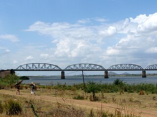
The Dona Ana Bridge spans the lower Zambezi River between the towns of Vila de Sena and Mutarara in Mozambique, effectively linking the two halves of the country. It was originally constructed as a railway bridge to link Malawi and the Moatize coal fields to the port of Beira.
Mutarara is a town in Mozambique. It lies on the north bank of the Zambezi River.
Vila de Sena or more commonly Sena is a town in Mozambique where there is a fundamental bridge over the Zambezi River. This bridge, the Dona Ana Bridge was originally a single track railway bridge, temporarily converted to road operation during the civil war.