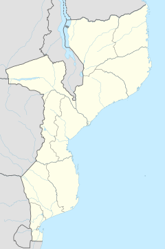
Nyasaland was a British protectorate located in Africa that was established in 1907 when the former British Central Africa Protectorate changed its name. Between 1953 and 1963, Nyasaland was part of the Federation of Rhodesia and Nyasaland. After the Federation was dissolved, Nyasaland became independent from Britain on 6 July 1964 and was renamed Malawi.

The British Central Africa Protectorate (BCA) was a British protectorate proclaimed in 1889 and ratified in 1891 that occupied the same area as present-day Malawi: it was renamed Nyasaland in 1907. British interest in the area arose from visits made by David Livingstone from 1858 onward during his exploration of the Zambezi area. This encouraged missionary activity that started in the 1860s, undertaken by the Universities' Mission to Central Africa, the Church of Scotland and the Free Church of Scotland, and which was followed by a small number of settlers. The Portuguese government attempted to claim much of the area in which the missionaries and settlers operated, but this was disputed by the British government. To forestall a Portuguese expedition claiming effective occupation, a protectorate was proclaimed, first over the south of this area, then over the whole of it in 1889. After negotiations with the Portuguese and German governments on its boundaries, the protectorate was formally ratified by the British government in May 1891.

Sir Henry Hamilton Johnston, frequently known as Harry Johnston, was a British explorer, botanist, artist, colonial administrator and linguist who traveled widely in Africa and spoke many African languages. He published 40 books on African subjects and was one of the key players in the Scramble for Africa that occurred at the end of the 19th century.
The British South Africa Company was chartered in 1889 following the amalgamation of Cecil Rhodes' Central Search Association and the London-based Exploring Company Ltd, which had originally competed to capitalize on the expected mineral wealth of Mashonaland but united because of common economic interests and to secure British government backing. The company received a Royal Charter modelled on that of the British East India Company. Its first directors included The 2nd Duke of Abercorn, Rhodes himself and the South African financier Alfred Beit. Rhodes hoped BSAC would promote colonisation and economic exploitation across much of south-central Africa, as part of the "Scramble for Africa". However, his main focus was south of the Zambezi, in Mashonaland and the coastal areas to its east, from which he believed the Portuguese could be removed by payment or force, and in the Transvaal, which he hoped would return to British control.
The African Lakes Corporation plc was a British company originally set-up in 1877 by Scottish businessmen to co-operate with Presbyterian missions in what is now Malawi. Despite its original connections with the Free Church of Scotland, it operated its businesses in Africa on a commercial rather than a philanthropic basis. It had political ambitions in the 1880s to control part of Central Africa and engaged in armed conflict with Swahili traders. Its businesses in the colonial era included water transport on the lakes and rivers of Central Africa, wholesale and retail trading including the operation of general stores, labour recruitment, landowning and later an automotive business. The company later diversified, but suffered an economic decline in the 1990s and was liquidated in 2007. One of the last Directors of the company kindly bought the records of the company and donated them to Glasgow University Archive Services, where they are still available for research.

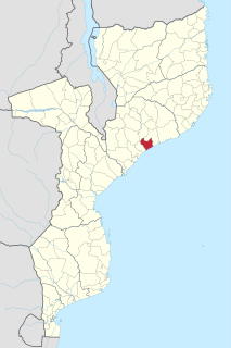
Chindio is a village on the north bank of the Zambezi River in Mozambique, downstream of its junction with the Shire River. Chindio is not the same place as Chinde, although they are both on the Zambezi and in Mozambique.

The 1890 British Ultimatum was an ultimatum by the British government delivered on 11 January 1890 to Portugal. The ultimatum forced the retreat of Portuguese military forces from areas which had been claimed by Portugal on the basis of historical discovery and recent exploration, but which the United Kingdom claimed on the basis of effective occupation. Portugal had attempted to claim a large area of land between its colonies of Mozambique and Angola including most of present-day Zimbabwe and Zambia and a large part of Malawi, which had been included in Portugal's "Rose-coloured Map".
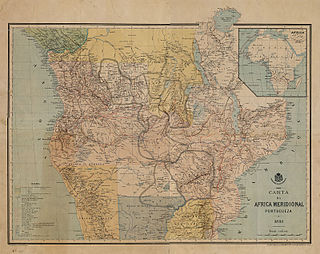
The Pink Map, also known in English as the Rose-Coloured Map, was a map prepared in 1885 to represent Portugal's claim of sovereignty over a land corridor connecting their colonies of Angola and Mozambique during the Scramble for Africa. The area claimed included most of what is currently Zimbabwe and large parts of modern Zambia and Malawi. In the first half of the 19th century, Portugal fully controlled only a few coastal towns in Angola and Mozambique. It also claimed suzerainty over other almost independent towns and nominally Portuguese subjects in the Zambezi valley, but could rarely enforce its claims; most of the territory now within Angola and Mozambique was entirely independent of Portuguese control. Between 1840 and 1869, Portugal expanded the area it controlled but felt threatened by the activities of other powers.
Articles related to Mozambique include:
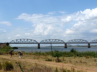
The Dona Ana Bridge spans the lower Zambezi River between the towns of Vila de Sena and Mutarara in Mozambique, effectively linking the two halves of the country. It was originally constructed as a railway bridge to link Malawi and the Moatize coal fields to the port of Beira.
Maganja da Costa District is a district of Zambezia Province in Mozambique.

The history of rail transport in Mozambique began in the latter years of the nineteenth century.
Eugene Charles Albert Sharrer was a British subject by naturalisation but of German descent, who was a leading entrepreneur in what is now Malawi for around fifteen years between his arrival in 1888 and his departure. He rapidly built-up commercial operations including wholesale and retail trading, considerable holdings of land, cotton and coffee plantations and a fleet of steamers on the Zambezi and Shire rivers. Sharrer was prominent in pressure groups that represented the interests of European planters and their businesses to the colonial authorities, and was responsible for the development of the first railway in what had become the British Central Africa Protectorate, whose construction was agreed in 1902. In 1902, Sharrer consolidate all his business interests into the British Central Africa Company Ltd and became its principal shareholder Shortly after this he left British Central Africa permanently for London, although he retained his financial interests in the territory. Very little is known of his history before he arrived in Central Africa but he died in London during the First World War.
The British Central Africa Company Ltd was one of the four largest European-owned companies that operated in colonial Nyasaland, now Malawi. The company was incorporated in 1902 to acquire the business interests that Eugene Sharrer, an early settler and entrepreneur, had developed in the British Central Africa Protectorate. Sharrer became the majority shareholder of the company on its foundation. The company initially had trading and transport interests, but these were sold by the 1930s. For most of the colonial period, its extensive estates produced cotton, tobacco or tea but the British Central Africa Company Ltd developed the reputation of being a harsh and exploitative landlord whose relations with its tenants were poor. In 1962, shortly before independence, the company sold most of its undeveloped land to the Nyasaland government, but it retained some plantations and two tea factories. It changed its name to The Central Africa Company Ltd and was acquired by the Lonrho group, both in 1964.
The Anglo-Portuguese Treaty of 1891 was an agreement between Great Britain and Portugal which fixed the boundaries between the British Central Africa Protectorate, and the territories administered by the British South Africa Company in Mashonaland and Matabeleland and North-Western Rhodesia and Portuguese Mozambique, and also between the British South Africa Company administered territories of North-Eastern Rhodesia, and Portuguese Angola.
John Buchanan (1855–1896), was a Scottish horticulturist who went to Central Africa, now Malawi, in 1876 as a lay member of the missionary party that established Blantyre Mission. Buchanan came to Central Africa as an ambitious artisan: his character was described as dour and devout but also as restlessly ambitious, and he saw in Central Africa a gateway to personal achievement. He started a mission farm on the site of Zomba, Malawi but was dismissed from the mission in 1881 for brutality. From being a disgraced missionary, Buchanan first became a very influential planter owning, with his brothers, extensive estates in Zomba District. He then achieved the highest position he could in the British administration as Acting British Consul to Central Africa from 1887 to 1891. In that capacity declared a protectorate over the Shire Highlands in 1889 to pre-empt a Portuguese expedition that intended to claim sovereignty over that region. In 1891, the Shire Highlands became part of the British Central Africa Protectorate. John Buchanan died at Chinde in Mozambique in March 1896 on his way to visit Scotland, and his estates were later acquired by the Blantyre and East Africa Ltd.

The history of rail transport in Malawi began shortly after the turn of the twentieth century.

The Shire Highlands Railway Company Ltd was a private railway company in colonial Nyasaland, incorporated in 1895 with the intention of constructing a railway from Blantyre to the effective head of navigation of the Shire River. After problems with routing and finance, a South African 3 ft 6 in gauge railway was constructed between 1903 and 1907, and extended in 1908 to a Nsanje, a distance of 113 miles (182 km) as water levels in the Shire River fell.
The Makololo chiefs recognised by the governments of colonial Nyasaland and independent Malawi have their origin in a group of porters that David Livingstone brought from Barotseland in the 1850s to support his first Zambezi expedition that did not return to Barotseland but assisted Livingstone and British missionaries in the area of southern Malawi between 1859 and 1864. After the withdrawal of the Universities' Mission to Central Africa those Makololo remaining in the Shire valley used firearms provided by the Europeans to attract dependants seeking protection, to seize land and to establish a number of chieftainships. At the time that a British protectorate was established in 1891, there were seven Makololo chiefs of which six were recognised by the government. Five survived to be given local governmental powers in 1933, and these powers continued after Malawi became independent. Although called Makololo or Kololo, after the ruling group in Barotseland in the 1850s, the majority came from peoples subject to the Makololo who adopted the more prestigious name. As, regardless of their origin, they took wives from among the inhabitants of the Shire Valley, their modern descendants have little connection with the Kololo people apart from their name.

Sena railway, also called Shire Highlands railway, Dondo-Malawi railway and North-South Malawi railway, is a railway that connects Dondo, Mozambique, to Chipata, in Zambia. It is c. 1000 km long, in a 1067 mm gauge.