This article relies largely or entirely on a single source .(February 2010) |
Chinna Irusampalayam | |
|---|---|
| Country | |
| State | Tamil Nadu |
| Languages | |
| • Official | Tamil |
| Time zone | UTC+5:30 (IST) |
Chinna Irusampalayam is a small village near Ariyankuppam in the Cuddalore district of the Tamil Nadu state of India. This village mainly depends on agriculture & cattle products. This village has only three streets namely Mudhal Theru (First Street), Nadu Theru (Middle Street) & Kadasi Theru (Last Street). This village has an Amman (Goddess) Temple.
Ariyankuppam is a Town, Commune, Sub-Taluk, Assembly Constituency in the Union Territory of Puducherry, India. The streets in Ariyankuppam are straight and in grid form, similar to Puducherry boulevard.

Cuddalore is a town which is the headquarters of the Cuddalore District in the south Indian state of Tamil Nadu. Scholars believe the name Cuddalore is derived from Koodalur, meaning confluence in Tamil. While the early history of Cuddalore remains unclear, the town first rose to prominence during the reign of Pallavas and Medieval Cholas. After the fall of Cholas, the town was ruled by various dynasties like Pandyas, Vijayanagar Empire, Madurai Nayaks, Thanjavur Nayaks, Thajavur Marathas, Tipu Sultan, French and the British Empire. Cuddalore was the scene of Seven Years' War and the Battle of Cuddalore in 1758 between the French and British. It has been a part of independent India since 1947. During the 2004 Indian Ocean earthquake, and the subsequent tsunamis it generated, Cuddalore was one of the affected towns, with 572 casualties.

Tamil Nadu is one of the 29 states of India. Its capital and largest city is Chennai. Tamil Nadu lies in the southernmost part of the Indian subcontinent and is bordered by the union territory of Puducherry and the South Indian states of Kerala, Karnataka, and Andhra Pradesh. It is bounded by the Eastern Ghats on the north, by the Nilgiri Mountains, the Meghamalai Hills, and Kerala on the west, by the Bay of Bengal in the east, by the Gulf of Mannar and the Palk Strait on the southeast, and by the Indian Ocean on the south. The state shares a maritime border with the nation of Sri Lanka.
This village can be reached by bus service to Ariyankuppam and from there by walk of 1.5 km. The road to reach this place is a zig zag one exactly resembling the crawling of a Snake. The roads are guarded by Paddy field and coconut fields.

Snakes are elongated, legless, carnivorous reptiles of the suborder Serpentes. Like all other squamates, snakes are ectothermic, amniote vertebrates covered in overlapping scales. Many species of snakes have skulls with several more joints than their lizard ancestors, enabling them to swallow prey much larger than their heads with their highly mobile jaws. To accommodate their narrow bodies, snakes' paired organs appear one in front of the other instead of side by side, and most have only one functional lung. Some species retain a pelvic girdle with a pair of vestigial claws on either side of the cloaca. Lizards have evolved elongate bodies without limbs or with greatly reduced limbs about twenty-five times independently via convergent evolution, leading to many lineages of legless lizards. Legless lizards resemble snakes, but several common groups of legless lizards have eyelids and external ears, which snakes lack, although this rule is not universal.
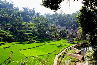
A paddy field is a flooded parcel of arable land used for growing semiaquatic rice. Paddy cultivation should not be confused with cultivation of deepwater rice, which is grown in flooded conditions with water more than 50 cm (20 in) deep for at least a month. Genetic evidence shows that all forms of paddy rice, both indica and japonica, spring from a domestication of the wild rice Oryza rufipogon that first occurred 8,200–13,500 years ago South of the Yangtze River in present-day China. However, the domesticated indica subspecies currently appears to be a product of the introgression of favorable alleles from japonica at a later date, so that there are possibly several events of cultivation and domestication. Paddy fields are the typical feature of rice farming in east, south and southeast Asia. Fields can be built into steep hillsides as terraces and adjacent to depressed or steeply sloped features such as rivers or marshes. They can require a great deal of labor and materials to create, and need large quantities of water for irrigation. Oxen and water buffalo, adapted for life in wetlands, are important working animals used extensively in paddy field farming.
This village is very near to the river Thiru Kanchi Aaaru, where the funeral services are performed every year for the deserted people. This hamlet is a part of Kilinjikuppam Panchayat Village under Cuddalore Block in Cuddalore District. [1]


