
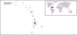
Saint Lucia is an island country in the West Indies in the eastern Caribbean Sea on the boundary with the Atlantic Ocean. The island was previously called Iyonola, the name given to the island by the native Arawaks, and later Hewanorra, the name given by the native Caribs, two separate Amerindian peoples. Part of the Windward Islands of the Lesser Antilles, it is located north/northeast of the island of Saint Vincent, northwest of Barbados and south of Martinique. It covers a land area of 617 km2 and reported a population of 165,595 in the 2010 census. Its capital is Castries. Soufrière was colonized by the French and was the original capital of the island.

Saint Lucia was inhabited by the Arawak and Kalinago Caribs before European contact in the early 16th century. It was colonized by the British and French in the 17th century and was the subject of several possession changes until 1814, when it was ceded to the British by France for the final time. In 1958, St. Lucia joined the short-lived semi-autonomous West Indies Federation. Saint Lucia was an associated state of the United Kingdom from 1967 to 1979 and then gained full independence on February 22, 1979.

Castries, population 20,000, aggl. 53,639, is the capital and largest city of Saint Lucia, an island country in the Caribbean. The quarter with the same name had a population of 70,000 on 22 May 2013 and stretches over an area of 80 km2 (31 sq mi).

The Gaspé Peninsula, also known as Gaspesia is a peninsula along the south shore of the Saint Lawrence River to the east of the Matapedia Valley in Quebec, Canada, that extends into the Gulf of Saint Lawrence. It is separated from New Brunswick on its southern side by Chaleur Bay and the Restigouche River. The name Gaspé comes from the Micmac word gespe'g, meaning "end", referring to the end of the land.

Vieux Fort is a district located in the southern part of Saint Lucia. Vieux Fort is also the name of the main town in the district. It is the home of the second-largest town on the island and is the home of Saint Lucia's international airport, Hewanorra International Airport.

Craney Island is a point of land in the independent city of Portsmouth in the South Hampton Roads region of eastern Virginia in the United States. The location, formerly in Norfolk County, is near the mouth of the Elizabeth River opposite Lambert's Point on Hampton Roads. It is home to the Craney Island US Naval Supply Center, managed by the U.S. Army Corps of Engineers.

The Pitons are two mountainous volcanic plugs, volcanic spires, located in Saint Lucia. Gros Piton is 798.25 m (2,618.9 ft) high, and Petit Piton is 743 m (2,438 ft) high; they are linked by the Piton Mitan ridge. The Pitons are a World Heritage Site, 2,909 ha in size, and located near the town of Soufrière.

Gros Islet is a community near the northern tip of the island country of Saint Lucia, in the Gros Islet Quarter. Originally a quiet fishing village, it has become one of the more popular tourist destinations in the country.
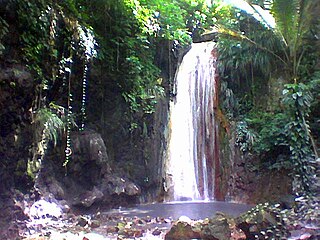
St. Lucia Botanical Gardens, also known as the Diamond Botanical Gardens, is home of the Diamond Waterfall and the oldest botanical gardens on the island of St. Lucia. The botanical garden is located in the town of Soufrière, in the South-Western region of the island St. Lucia.

The Vieux Fort River is a river in Saint Lucia. It flows south-southeast, reaching the coast close to the country's southernmost point at the town of Vieux Fort. It is named after a fort that used to watch out towards Saint Vincent towards the south.

Pigeon Island is a 44-acre (180,000 m2) islet located in Gros Islet in the northern region of Saint Lucia. Once isolated from the country in the Caribbean Sea, the island was artificially joined to the western coast of mainland in 1972 by a man-made causeway built from dirt excavated to form the Rodney Bay Marina. Composed of two peaks the island is a historic site with numerous forts such as an 18th-century British fort and Fort Rodney both used by the British to spy on French Ships from neighbouring Martinique. In 1979 it was named a national park and again in 1992 it became a national landmark under the control of the Saint Lucia National Trust (SLNT). Today, Pigeon Island is the home and major venue of the Saint Lucia Jazz Festival.
Morne Fortune is a hill and residential area located south of Castries, Saint Lucia, in the West Indies.
The following is an alphabetical list of topics related to the nation of Saint Lucia.
The Black Bay River is a river in Vieux Fort Quarter of the island nation of Saint Lucia.
The Choc River is a river in the Soufrière Quarter of the island country of Saint Lucia. It flows to the Caribbean Sea.
Beane Air Force Base was a United States Air Force base located near Vieux Fort, Saint Lucia, in the Caribbean Sea. It is now the site of Hewanorra International Airport.
Soufrière Estate, located on the Caribbean island of Saint Lucia, was originally established in 1713 as a 2,000-acre (8.1 km2) estate granted to three Devaux brothers for services to King Louis XIV of France. Later on, mineral springs were discovered and were used as restorative baths by the French soldiers. In 1784, the Baron de Laborie, the French Governor of St Lucia, sent samples of the water to Paris for testing and it is believed to be good for rheumatism and skin complaints.
Vieux Fort is a town located near the southernmost point of Saint Lucia, a Caribbean island. It is named after a fort that used to watch out towards Saint Vincent towards the south. The population is about 4,500, while the surrounding district of Vieux Fort Quarter has a total population of about 16,000.

Vigie is part of Castries, Saint Lucia.

Fort Norfolk is a historic fort and national historic district located at Norfolk, Virginia. With the original buildings having been built between 1795 and 1809, the fort encloses 11 buildings: main gate, guardhouse, officers' quarters, powder magazine, and carpenter's shop. Fort Norfolk is the last remaining fortification of President George Washington's 18th century harbor defenses, later termed the first system of US fortifications. It has served as the district office for the U.S. Army Engineer District, Norfolk since 1923.
