Liberia, officially the Republic of Liberia, is a country on the West African coast. It is bordered by Sierra Leone to its northwest, Guinea to its north, Ivory Coast to its east, and the Atlantic Ocean to its south and southwest. It has a population of around five and one-half million and covers an area of 43,000 square miles (111,369 km2). The country's official language is English; however, over 20 indigenous languages are spoken, reflecting the country's ethnic and cultural diversity. The capital and largest city is Monrovia.

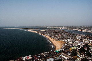
Monrovia is the capital and largest city of Liberia. Founded in 1822, it is located on Cape Mesurado on the Atlantic coast and as of the 2022 census had 1,761,032 residents, home to 33.5% of Liberia’s total population. Its Metro Area including Montserrado and Margibi counties largely being urbanized, was home to 2,225,911 inhabitants as of the 2022 census. As the nation's primate city, Monrovia is the country's economic, financial and cultural center; its economy is primarily centered on its harbor and its role as the seat of Liberian government.

Montserrado County is a county in the northwestern portion of the West African nation of Liberia containing its national capital, Monrovia. One of 15 counties that comprise the first-level of administrative division in the nation, it has 17 sub political districts. As of the 2022 Census, it had a population of 1,920,914, making it the most populous county in Liberia. The area of the county measures 738.5 square miles (1,913 km2), the smallest in the country. Bensonville serves as the capital.

Grand Cape Mount is a county in the northwestern portion of the West African nation of Liberia. One of 15 counties that constitute the first-level of administrative division in the nation, it has five districts. Robertsport serves as the capital with the area of the county measuring 1,993 square miles (5,160 km2). As of the 2008 Census, it had a population of 129,817, making it the eighth most populous county in Liberia. The county is bordered by Gbarpolu County to the northeast and Bomi County to the southeast. The northern part of Grand Cape Mount borders the nation of Sierra Leone, while to the west lies the Atlantic Ocean.

Bomi is a county in the northwestern portion of the West African nation of Liberia. The county was established in 1984. The county's area is 746 square miles (1,900 km2).

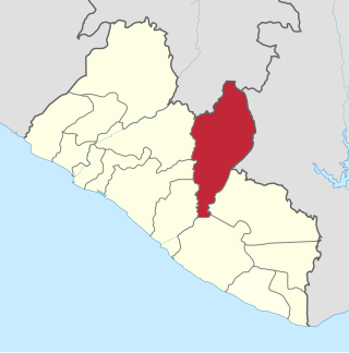
Bong is a county in the north-central portion of the West African nation of Liberia. One of 15 counties that comprise the first-level of administrative division in the nation, it has twelve districts. Gbarnga serves as the capital. The area of the county measures 8,772 square kilometres (3,387 sq mi). As of the 2022 Census, it had a population of 467,502, making it the third-most populous county in Liberia. The county was organized in 1964 and is important for its mining industry.
Careysburg District is one of four districts located in Montserrado County, Liberia. Bensonville is the capital, and the total district population is 28,463.
Greater Monrovia is one of four districts located in Montserrado County, Liberia. It contains the country's capital Monrovia. It recorded a population of 970,824 in the 2008 census.
West Point is a township of the Liberian capital city of Monrovia, located on a 0.53 km2 peninsula which juts out into the Atlantic Ocean between the Mesurado and Saint Paul rivers. West Point is one of Monrovia's most densely populated slums.
Caldwell is a township located in Montserrado County, Liberia. Caldwell was one of the four townships established in the first wave of colonization. It is listed as one of the original settlements comprising the Commonwealth of Liberia in the 1839 Constitution, which was drafted by the American Colonization Society. The name comes from Elias B. Caldwell and family, about 1816, Presbyterians in what became Caldwell, New Jersey.

New Georgia is a township in Montserrado County, Liberia that was first settled by Africans who had been taken from slave ships seized or wrecked near the United States and then sent to Liberia after several years had passed.
Kparblee District is one of 17 Administrative Districts of Nimba County, Liberia. In 2008, the population was 11,424. It is located in Tappita Statutory District and situated along the Cestos River which borders Liberia with the Republic of Côte d'Ivoire, commonly called the Ivory Coast.

Liberia is one of the poorest countries in the world. Civil wars have killed around 250,000 people and displaced many more. The wars ended in 2003 but destroyed most of the country's healthcare facilities. Recovery precedes proceeds, but the majority of the population still lives below the international poverty line. Life expectancy in Liberia is much lower than the world average. Communicable diseases are widespread, including tuberculosis, diarrhea, malaria, HIV, and Dengue. Female genital mutilation is widely practiced. Nearly a quarter of children under the age of five are malnourished and few people have access to adequate sanitation facilities. In 2009, government expenditure on health care per-capita was US$22, accounting for 10.6% of totaled GDP. In 2008, Liberia had only one doctor and 27 nurses per 100,000 people. It was ill-equipped to handle the outbreak of Ebola in 2014 and 2015.
New Kru Town is a northwestern coastal suburb of Monrovia, Liberia.
The following is a timeline of the history of the city of Monrovia, Liberia.
Chicken Soup Factory is a community in Gardnesville Township, Greater Monrovia District, Liberia. The name hails from a defunct Maggi chicken bouillon cube factory located in the area.
Key & Death Hole is a community in the township of Congo Town, Greater Monrovia District, Liberia. The community is located on the eastern, i.e. Old Road, side of the Spriggs Payne Airport. The name Death Hole stems from massacres of the Liberian Civil War, occurring near the airfield in 1990. An alternative name for the area is Tweh-Johnsonville, after Matthew Tweh and Rt. Gen. J. Samuel Johnson.
Swankamore is a community in Congo Town, Greater Monrovia District, Liberia. The community is located SKD Boulevard.
Dixville is a township in Greater Monrovia District, Montserrado County, Liberia. The Dixville township was one of five townships founded in the second wave of colonization, between 1828 and 1847.

The Garworlohn Township is a township of the Greater Monrovia District, Montserrado County, Liberia. It is located on Bushrod Island, and stretches from Vai Town in the south to Bong Mines Bridge in the north. Politically, Garworlohn Township is divided between the Montserrado-13, Montserrado-14 and Montserrado-15 electoral districts.