Choctaw Corner

Last updated

The Choctaw Corner is a former Native American boundary location near the modern border between Clarke and Marengo counties in Alabama, United States. It was established as the northernmost terminus for a mutually agreed upon boundary line between the Choctaw and Creek peoples during the Mississippi Territory period. [1] [2] This boundary line, now known as the “Old Indian Treaty Boundary,” starts at the Alabama River cut-off in southernmost Clarke County and follows a northward path through the county along the drainage divide between the Tombigbee and Alabama rivers to the Choctaw Corner, then turns ninety degrees to the west and follows the modern county-line between Clarke and Marengo to the Tombigbee River. [3]

Native Americans in the United States Indigenous peoples of the United States (except Hawaii)

Native Americans, also known as American Indians, Indigenous Americans and other terms, are the indigenous peoples of the United States, except Hawaii. There are over 500 federally recognized tribes within the US, about half of which are associated with Indian reservations. The term "American Indian" excludes Native Hawaiians and some Alaska Natives, while Native Americans are American Indians, plus Alaska Natives of all ethnicities. Native Hawaiians are not counted as Native Americans by the US Census, instead being included in the Census grouping of "Native Hawaiian and other Pacific Islander".

Borders are geographic boundaries of political entities or legal jurisdictions, such as governments, sovereign states, federated states, and other subnational entities. Borders are established through agreements between political or social entities that control those areas; the creation of these agreements is called boundary delimitation.

Clarke County, Alabama County in the United States

Clarke County is a county of the U.S. state of Alabama. As of the 2010 census, the population was 25,833. The county seat is Grove Hill. The county was created by the legislature of the Mississippi Territory in 1812. It is named in honor of General John Clarke of Georgia, who was later elected governor of that state.

Contents

History

Beginning a decade prior to the eruption of the Creek War, the Choctaw Corner had its roots in white settlement of territory that the Creek saw as encroachment upon their western lands. They had already experienced white encroachment on their eastern lands in Georgia. The Choctaw claimed the lands in modern Clarke County from the Tombigbee River eastward to the watershed as theirs. [4] Although the Creek had traditionally claimed the lands from the Alabama River westward to the watershed, as early as 1802 the Alibamu people, as the closest members of the Creek Confederacy to the new settlers, claimed that their territory reached all the way across to the Tombigbee. [3]

Creek War regional war between opposing Creek factions, European empires, and the United States

The Creek War (1813–1814), also known as the Red Stick War and the Creek Civil War, was a regional war between opposing Creek factions, European empires and the United States, taking place largely in today's Alabama and along the Gulf Coast. The major conflicts of the war took place between state militia units and the "Red Stick" Creeks.

Georgia (U.S. state) State of the United States of America

Georgia is a state in the Southeastern United States. It began as a British colony in 1733, the last and southernmost of the original Thirteen Colonies to be established. Named after King George II of Great Britain, the Province of Georgia covered the area from South Carolina south to Spanish Florida and west to French Louisiana at the Mississippi River. Georgia was the fourth state to ratify the United States Constitution, on January 2, 1788. In 1802–1804, western Georgia was split to the Mississippi Territory, which later split to form Alabama with part of former West Florida in 1819. Georgia declared its secession from the Union on January 19, 1861, and was one of the original seven Confederate states. It was the last state to be restored to the Union, on July 15, 1870. Georgia is the 24th largest and the 8th most populous of the 50 United States. From 2007 to 2008, 14 of Georgia's counties ranked among the nation's 100 fastest-growing, second only to Texas. Georgia is known as the Peach State and the Empire State of the South. Atlanta, the state's capital and most populous city, has been named a global city. Atlanta's metropolitan area contains about 55% of the population of the entire state.

Alabama people Southeastern culture people of Native Americans

The Alabama or Alibamu are a Southeastern culture people of Native Americans, originally from Alabama. They were members of the Muscogee Creek Confederacy, a loose trade and military organization of autonomous towns; their home lands were on the upper Alabama River.

Historical marker detailing the history of the Choctaw Corner. Choctaw Corner Historical Marker.jpg
Historical marker detailing the history of the Choctaw Corner.

After much persuasion, veiled threats, and a payment of $50,000 plus an annuity in goods of $3000, the Choctaw signed the Treaty of Mount Dexter with the United States on November 16, 1805 that ceded 4,142,720 acres (16,765.0 km2) of their territory, including the disputed land east of the Tombigbee, to the Americans. [5]

Treaty of Mount Dexter

The Treaty of Mount Dexter was signed between the United States and the Choctaws. The treaty was signed November 16, 1805. The 4,142,720-acre (16,765.0 km2) area ceded was from the Natchez District to the Tombigbee Alabama River watershed, mostly in present-day Mississippi.

In about 1808 the two Native American peoples decided to settle their argument over control of the strip of land between the two rivers by a traditional ball game. The Choctaw won but the Creek were dissatisfied with the results. The two groups decided to let the women play, and the Choctaw women won as well, which settled the dispute. [2] [3]

Possibly disappointed that the treaty did not include the fertile lands on the east bank of the Mississippi River, President Thomas Jefferson had delayed ratification in the Senate for over two years after the signing. [5] The boundary line was finally surveyed in 1809, with both Creek and Choctaw assisting. [3] [6]

Mississippi River largest river system in North America

The Mississippi River is the second-longest river and chief river of the second-largest drainage system on the North American continent, second only to the Hudson Bay drainage system. Its source is Lake Itasca in northern Minnesota and it flows generally south for 2,320 miles (3,730 km) to the Mississippi River Delta in the Gulf of Mexico. With its many tributaries, the Mississippi's watershed drains all or parts of 32 U.S. states and two Canadian provinces between the Rocky and Appalachian mountains. The main stem is entirely within the United States; the total drainage basin is 1,151,000 sq mi (2,980,000 km2), of which only about one percent is in Canada. The Mississippi ranks as the fourth-longest and fifteenth-largest river by discharge in the world. The river either borders or passes through the states of Minnesota, Wisconsin, Iowa, Illinois, Missouri, Kentucky, Tennessee, Arkansas, Mississippi, and Louisiana.

Thomas Jefferson 3rd president of the United States

Thomas Jefferson was an American statesman, diplomat, lawyer, architect, and Founding Father who served as the third president of the United States from 1801 to 1809. Previously, he had served as the second vice president of the United States from 1797 to 1801. The principal author of the Declaration of Independence, Jefferson was a proponent of democracy, republicanism, and individual rights motivating American colonists to break from the Kingdom of Great Britain and form a new nation; he produced formative documents and decisions at both the state and national level.

United States Senate Upper house of the United States Congress

The United States Senate is the upper chamber of the United States Congress, which along with the United States House of Representatives—the lower chamber—comprises the legislature of the United States. The Senate chamber is located in the north wing of the Capitol, in Washington, D.C.

Several years after the Indian Removal in the 1830s, European-American settlers founded a new town named Choctaw Corner a few miles southeast of the old boundary marker. [3]

Choctaw Corner, Alabama in Alabama, United States

Choctaw Corner was a former town in Clarke County, Alabama, United States. It is named for the nearby Choctaw Corner, which marked the border between the native Choctaw and Creek peoples prior to the Indian removal. The community was one of the earliest settlements in the county.

See also

Related Research Articles

Trail of Tears Series of forced relocations of Native Americans

The Trail of Tears was a series of forced relocations of Native Americans in the United States from their ancestral homelands in the Southeastern United States, to areas to the west that had been designated as Indian Territory. The forced relocations were carried out by government authorities following the passage of the Indian Removal Act in 1830. The relocated peoples suffered from exposure, disease, and starvation while en route to their new designated reserve, and many died before reaching their destinations. The forced removals included members of the Cherokee, Muscogee (Creek), Seminole, Chickasaw, Choctaw, and Ponca nations, as well as their African slaves. The phrase "Trail of Tears" originates from a description of the removal of many Native American tribes, including the infamous Cherokee Nation relocation in 1838.

Washington County, Alabama County in the United States

Washington County is a county in the U.S. state of Alabama. As of the 2010 census, the population was 17,581. The county seat is Chatom. The county was named in honor of George Washington, the first President of the United States. It is a dry county, with the exception of Chatom.

Clarke County, Mississippi County in the United States

Clarke County is a county located in the U.S. state of Mississippi. As of the 2010 census, the population was 16,732. Its county seat is Quitman. Clarke County is named for Joshua G. Clarke, the first Mississippi state chancellor and judge.

Five Civilized Tribes Native American grouping

The term "Five Civilized Tribes" derives from the colonial and early federal period in the history of the United States. It refers to five Native American nations—the Cherokee, Chickasaw, Choctaw, Creek (Muscogee), and Seminole. These are the first five tribes that Anglo-European settlers generally considered to be "civilized". Examples of colonial attributes adopted by these five tribes include Christianity, centralized governments, literacy, market participation, written constitutions, intermarriage with white Americans, and plantation slavery practices. The Five Civilized Tribes tended to maintain stable political relations with the Europeans.

Pinckneys Treaty

Pinckney's Treaty, also commonly known as the Treaty of San Lorenzo or the Treaty of Madrid, was signed in San Lorenzo de El Escorial on October 27, 1795 and established intentions of friendship between the United States and Spain. It also defined the border between the United States and Spanish Florida, and guaranteed the United States navigation rights on the Mississippi River. With this agreement, the first phase of the ongoing border dispute between the two nations in this region, commonly called the West Florida Controversy, came to a close.

Mississippi Territory territory of the USA between 1798-1817

The Territory of Mississippi was an organized incorporated territory of the United States that existed from April 7, 1798, until December 10, 1817, when the western half of the territory was admitted to the Union as the State of Mississippi and the eastern half became the Alabama Territory until its admittance to the Union as the State of Alabama on December 14, 1819.

Tombigbee River river in the United States of America

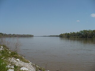
The Tombigbee River is a tributary of the Mobile River, approximately 200 mi (325 km) long, in the U.S. states of Mississippi and Alabama. Together with the Alabama, it merges to form the short Mobile River before the latter empties into Mobile Bay on the Gulf of Mexico. The Tombigbee watershed encompasses much of the rural coastal plain of western Alabama and northeastern Mississippi, flowing generally southward. The river provides one of the principal routes of commercial navigation in the southern United States, as it is navigable along much of its length through locks and connected in its upper reaches to the Tennessee River via the Tennessee-Tombigbee Waterway.

George Strother Gaines had an influential role in the early history of Alabama and Mississippi. During his long and varied career he was a federal trade agent for the region's Indian tribes, explored the country west of the Mississippi River and supervised the removal of Choctaw Indians. He also served as a state senator, banker, and railroad lobbyist.

Fort Stoddert

Fort Stoddert/Stoddard was a stockade fort in the Mississippi Territory, in what is today Alabama. It was located on a bluff of the Mobile River, near modern Mount Vernon, close to the confluence of the Tombigbee and Alabama Rivers. It served as the western terminus of the Federal Road which ran through Choctaw lands to Fort Wilkinson in Georgia. The fort, built in 1799, was named for Benjamin Stoddert also attributed to Amos Stoddard married to Phoebe Reed, contemporaries of Daniel Reed his wife Rose Reed and his brothers Amos Reed and Squire Reed, the secretary to the Continental Board of War during the American Revolution and Secretary of the Navy during the Quasi War. Fort Stoddert/Stoddard was built by the United States to keep the peace by preventing its own settlers in the Tombigbee District from attacking the Spanish in the Mobile District.

Noxubee River river in the United States of America

The Noxubee River (NAHKS-uh-bee) is a tributary of the Tombigbee River, about 90.6 miles (145.8 km) long, in east-central Mississippi and west-central Alabama in the United States. Via the Tombigbee, it is part of the watershed of the Mobile River, which flows to the Gulf of Mexico.

Treaty of Doaks Stand

The Treaty of Doak's Stand was signed on October 18, 1820 between the United States and the Choctaw Indian tribe. Based on the terms of the accord, the Choctaw agreed to give up approximately one-half of their remaining Choctaw homeland. In October 1820, Andrew Jackson and Thomas Hinds were sent as commissioners who represented the United States to negotiate a treaty to surrender a large portion of Choctaw country in Mississippi. They met with tribal representatives at Doak's Stand on the Natchez Trace. They met with the chiefs Pushmataha, Mushulatubbee, and Apuckshunubbee, who represented the three major regional divisions of the Choctaw. Chiefs of the towns and other prominent men accompanied them, such as Colonel Silas Dinsmoor.

Dancing Rabbit Creek Treaty Site

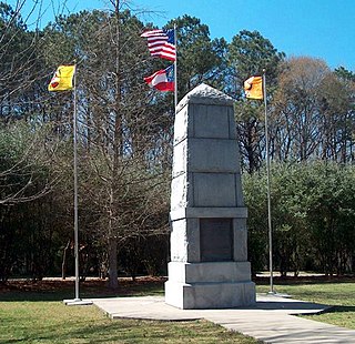
The Dancing Rabbit Creek Treaty Site is a historic Choctaw Native American gathering place in rural Noxubee County, Mississippi. Located near a freshwater spring above the floodplain of Dancing Rabbit Creek in the southwestern part of the county, it was the site of a treaty negotiation between the Choctaw and the federal government in 1830, resulting in the Treaty of Dancing Rabbit Creek, in which the Choctaw agreed to surrender their ancestral lands for territory in what is now Oklahoma. It was the first treaty negotiated after passage of the Indian Removal Act, and served as a model for other treaties passed pursuant to that act. It also led to the Choctaw Trail of Tears. The site, now marked by a stone memorial and a small Choctaw cemetery, was designated a National Historic Landmark in 1996.

Choctaw Trail of Tears

The Choctaw Trail of Tears was the relocation of the Choctaw Nation from their country referred to now as the Deep South to lands west of the Mississippi River in Indian Territory in the 1830s. A Choctaw miko (chief) was quoted by the Arkansas Gazette that the removal was a "trail of tears and death." After removal the Choctaws became three distinct groups, the Choctaw Nation of Oklahoma, Jena Band of Choctaw Indians, and the Mississippi Band of Choctaw Indians.

Fort Sinquefield

Fort Sinquefield is the historic site of a wooden stockade fortification in Clarke County, Alabama, near the modern town of Grove Hill. It was built by early Clarke County pioneers as protection during the Creek War and was attacked in 1813 by Creek warriors.

Half Acre, Alabama Unincorporated community in Alabama, United States

Half Acre is an unincorporated community in Marengo County, Alabama, United States. It has gone through a variety of name changes since the early 20th century. The community had a post office at one time, but it no longer exists. Although a thriving community in its early years, it has since dwindled into obscurity.

Tombigbee District

The Tombigbee District, also known as the Tombigbee settlements, was one of two areas, the other being the Natchez District, that were the first in what was West Florida to be colonized by British subjects from the Thirteen Colonies and elsewhere. This later became the Mississippi Territory as part of the United States. The district was also the first area to be opened to white settlement in what would become the state of Alabama, outside of the French colonial outpost of Mobile on the Gulf Coast. The Tombigbee and Natchez districts were the only areas populated by whites in the Mississippi Territory when it was formed by the United States in 1798.

Horse Creek is a stream and tributary of the Tombigbee River in southern Marengo County and northern Clarke County in Alabama.

The Treaty of Dewitts Corner ended the initial Overhill Cherokee town attacks which took place at the beginning of the American Revolution. Signed between the Cherokee and South Carolina, the treaty helped lay the foundation for the decades long Cherokee–American wars fought between the European-Americans and the Chickamauga Cherokee people.

References

  1. "Clarke County's Historical Markers". Clarke County Historical Society. Clarke County, Alabama official website. Archived from the original on July 30, 2007. Retrieved July 27, 2011.
  2. 1 2 "Choctaw Corner". Clarke County Historical Society. The Historical Marker Database. Retrieved July 27, 2011.
  3. 1 2 3 4 5 Halbert, H. S.; Ball, T. H. (1895). The Creek War of 1813 and 1814. Chicago: Donohue and Henneberry. pp. 35–36. ISBN   0-8173-0775-3.
  4. ""Clarke County MPS"". National Register of Historic Places. National Park Service. Retrieved July 27, 2011.
  5. 1 2 Clark, Thomas D.; John D. W. Guice (1989). The Old Southwest 1795–1830: Frontiers in Conflict. Albuquerque: University of New Mexico Press. pp. 36–37. ISBN   0-8061-2836-4.
  6. Finlay, Louis M. Jr. (Summer 2000). "The Mitchell Reserve". Clarke County Historical Society Quarterly. 25 (1): 9.

Coordinates: 31°59′26″N87°49′11″W / 31.99046°N 87.81986°W / 31.99046; -87.81986