Maszkienice is a village in the administrative district of Gmina Dębno, within Brzesko County, Lesser Poland Voivodeship, in southern Poland. It lies approximately 5 kilometres (3 mi) north-west of Dębno, 6 km (4 mi) east of Brzesko, and 54 km (34 mi) east of the regional capital Kraków.
Jastrzębia is a village in the administrative district of Gmina Ciężkowice, within Tarnów County, Lesser Poland Voivodeship, in southern Poland. It lies approximately 9 kilometres (6 mi) west of Ciężkowice, 29 km (18 mi) south-west of Tarnów, and 72 km (45 mi) south-east of the regional capital Kraków.
Pawęzów is a village in the administrative district of Gmina Lisia Góra, within Tarnów County, Lesser Poland Voivodeship, in southern Poland. It lies approximately 4 kilometres (2 mi) south-west of Lisia Góra, 4 km (2 mi) north of Tarnów, and 75 km (47 mi) east of the regional capital Kraków.
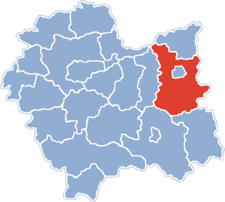
Łowczówek is a village in the administrative district of Gmina Pleśna, within Tarnów County, Lesser Poland Voivodeship, in southern Poland. It lies approximately 13 kilometres (8 mi) south of Tarnów and 77 km (48 mi) east of the regional capital Kraków.
Radlna is a village in the administrative district of Gmina Tarnów, within Tarnów County, Lesser Poland Voivodeship, in southern Poland. It lies approximately 8 kilometres (5 mi) south of Tarnów and 76 km (47 mi) east of the regional capital Kraków.
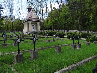
Zbylitowska Górapronounced [zbɨliˈtɔfska ˈɡura] is a village in the administrative district of Gmina Tarnów, within Tarnów County, Lesser Poland Voivodeship, in southern Poland. It lies approximately 9 kilometres (6 mi) south-west of Tarnów and 71 km (44 mi) east of the regional capital Kraków. It is the site of a mass grave from World War II, marked by a monument.
Zgłobice is a village in the administrative district of Gmina Tarnów, within Tarnów County, Lesser Poland Voivodeship, in southern Poland. It lies approximately 9 kilometres (6 mi) south-west of Tarnów and 71 km (44 mi) east of the regional capital Kraków.
Łętowice is a village in the administrative district of Gmina Wierzchosławice, within Tarnów County, Lesser Poland Voivodeship, in southern Poland. It lies approximately 13 kilometres (8 mi) south-west of Tarnów and 66 km (41 mi) east of the regional capital Kraków.
Biadoliny Radłowskie is a village in the administrative district of Gmina Wojnicz, within Tarnów County, Lesser Poland Voivodeship, in southern Poland. It lies approximately 5 kilometres (3 mi) north-west of Wojnicz, 17 km (11 mi) west of Tarnów, and 62 km (39 mi) east of the regional capital Kraków.
Isep is a village in the administrative district of Gmina Wojnicz, within Tarnów County, Lesser Poland Voivodeship, in southern Poland. It lies approximately 4 kilometres (2 mi) south of Wojnicz, 16 km (10 mi) south-west of Tarnów, and 67 km (42 mi) east of the regional capital Kraków.
Łopoń is a village in the administrative district of Gmina Wojnicz, within Tarnów County, Lesser Poland Voivodeship, in southern Poland. It lies approximately 5 kilometres (3 mi) north-west of Wojnicz, 17 km (11 mi) west of Tarnów, and 62 km (39 mi) east of the regional capital Kraków.
Zakrzów is a village in the administrative district of Gmina Wojnicz, within Tarnów County, Lesser Poland Voivodeship, in southern Poland. It lies approximately 2 kilometres (1 mi) east of Wojnicz, 14 km (9 mi) south-west of Tarnów, and 67 km (42 mi) east of the regional capital Kraków.
Faliszowice is a village in the administrative district of Gmina Zakliczyn, within Tarnów County, Lesser Poland Voivodeship, in southern Poland. It lies approximately 6 kilometres (4 mi) west of Zakliczyn, 28 km (17 mi) southwest of Tarnów, and 62 km (39 mi) east of the regional capital Kraków.
Faściszowa is a village in the administrative district of Gmina Zakliczyn, within Tarnów County, Lesser Poland Voivodeship, in southern Poland. It lies approximately 2 kilometres (1 mi) east of Zakliczyn, 24 km (15 mi) south-west of Tarnów, and 69 km (43 mi) east of the regional capital Kraków.
Lusławice is a village in the administrative district of Gmina Zakliczyn, within Tarnów County, Lesser Poland Voivodeship, in southern Poland. It lies approximately 1 kilometre (1 mi) south-west of Zakliczyn, 25 km (16 mi) south-west of Tarnów, and 68 km (42 mi) east of the regional capital Kraków.
Słona is a Polish village in the administrative district of Gmina Zakliczyn, within Tarnów County, Lesser Poland Voivodeship, in southern Poland. It lies approximately 4 kilometres (2 mi) south-east of Zakliczyn, 25 km (16 mi) south-west of Tarnów, and 71 km (44 mi) east of the regional capital Kraków.
Wróblowice is a village in the administrative district of Gmina Zakliczyn, within Tarnów County, Lesser Poland Voivodeship, in southern Poland. It lies approximately 4 kilometres (2 mi) north-east of Zakliczyn, 22 km (14 mi) south-west of Tarnów, and 69 km (43 mi) east of the regional capital Kraków.
Zdonia is a village in the administrative district of Gmina Zakliczyn, within Tarnów County, Lesser Poland Voivodeship, in southern Poland. It lies approximately 2 kilometres (1 mi) west of Zakliczyn, 25 km (16 mi) south-west of Tarnów, and 67 km (42 mi) east of the regional capital Kraków.
Swoszowa is a village in the administrative district of Gmina Szerzyny, within Tarnów County, Lesser Poland Voivodeship, in southern Poland. It lies approximately 5 kilometres (3 mi) north-west of Szerzyny, 27 km (17 mi) south-east of Tarnów, and 96 km (60 mi) east of the regional capital Kraków.
Lusławice is a village in the administrative district of Gmina Zakliczyn, within Tarnów County, Lesser Poland Voivodeship, in southern Poland. It lies approximately 1 kilometre (1 mi) south-west of Zakliczyn, 25 km (16 mi) south-west of Tarnów, and 68 km (42 mi) east of the regional capital Kraków.