Kępino is a village in the administrative district of Gmina Borów, within Strzelin County, Lower Silesian Voivodeship, in south-western Poland. Prior to 1945 it was in Germany. It lies approximately 6 kilometres (4 mi) south of Borów, 7 km (4 mi) north-west of Strzelin, and 33 km (21 mi) south of the regional capital Wrocław.
Basonia is a village in the administrative district of Gmina Józefów nad Wisłą, within Opole Lubelskie County, Lublin Voivodeship, in eastern Poland. It lies approximately 18 kilometres (11 mi) south-west of Opole Lubelskie and 58 km (36 mi) south-west of the regional capital Lublin.
Ostrusza is a village in the administrative district of Gmina Ciężkowice, within Tarnów County, Lesser Poland Voivodeship, in southern Poland. It lies approximately 5 kilometres (3 mi) south-east of Ciężkowice, 28 km (17 mi) south of Tarnów, and 84 km (52 mi) east of the regional capital Kraków.

Brzozowa is a village in the administrative district of Gmina Gromnik, within Tarnów County, Lesser Poland Voivodeship, in southern Poland. It lies approximately 25 kilometres (16 mi) south-west of Tarnów and 72 km (45 mi) east of the regional capital Kraków.
Ładna is a village in the administrative district of Gmina Skrzyszów, within Tarnów County, Lesser Poland Voivodeship, in southern Poland. It lies approximately 7 kilometres (4 mi) east of Tarnów and 83 km (52 mi) east of the regional capital Kraków.
Łękawka is a village in the administrative district of Gmina Tarnów, within Tarnów County, Lesser Poland Voivodeship, in southern Poland. It lies approximately 11 kilometres (7 mi) south of Tarnów and 80 km (50 mi) east of the regional capital Kraków.
Poręba Radlna is a village in the administrative district of Gmina Tarnów, within Tarnów County, Lesser Poland Voivodeship, in southern Poland. It lies approximately 10 kilometres (6 mi) south of Tarnów and 77 km (48 mi) east of the regional capital Kraków.
Lubaszowa is a village in the administrative district of Gmina Tuchów, within Tarnów County, Lesser Poland Voivodeship, in southern Poland. It lies approximately 4 kilometres (2 mi) south of Tuchów, 19 km (12 mi) south of Tarnów, and 82 km (51 mi) east of the regional capital Kraków.
Siedliska is a village in the administrative district of Gmina Tuchów, within Tarnów County, Lesser Poland Voivodeship, in southern Poland. It lies approximately 6 kilometres (4 mi) south-west of Tuchów, 19 km (12 mi) south of Tarnów, and 80 km (50 mi) east of the regional capital Kraków.
Zabłędza is a village in the administrative district of Gmina Tuchów, within Tarnów County, Lesser Poland Voivodeship, in southern Poland. It lies approximately 4 kilometres (2 mi) north of Tuchów, 13 km (8 mi) south-east of Tarnów, and 82 km (51 mi) east of the regional capital Kraków.
Dębina Łętowska is a village in the administrative district of Gmina Wojnicz, within Tarnów County, Lesser Poland Voivodeship, in southern Poland. It lies approximately 1 kilometre (1 mi) south-west of Wojnicz, 15 km (9 mi) south-west of Tarnów, and 65 km (40 mi) east of the regional capital Kraków.
Faściszowa is a village in the administrative district of Gmina Zakliczyn, within Tarnów County, Lesser Poland Voivodeship, in southern Poland. It lies approximately 2 kilometres (1 mi) east of Zakliczyn, 24 km (15 mi) south-west of Tarnów, and 69 km (43 mi) east of the regional capital Kraków.
Filipowice is a village in the administrative district of Gmina Zakliczyn, within Tarnów County, Lesser Poland Voivodeship, in southern Poland. It lies approximately 8 kilometres (5 mi) west of Zakliczyn, 31 km (19 mi) south-west of Tarnów, and 62 km (39 mi) south-east of the regional capital Kraków.
Jamna is a village in the administrative district of Gmina Zakliczyn, within Tarnów County, Lesser Poland Voivodeship, in southern Poland. It lies approximately 10 kilometres (6 mi) south of Zakliczyn, 32 km (20 mi) south of Tarnów, and 73 km (45 mi) south-east of the regional capital Kraków.
Kończyska is a village in the administrative district of Gmina Zakliczyn, within Tarnów County, Lesser Poland Voivodeship, in southern Poland. It lies approximately 2 kilometres (1 mi) south of Zakliczyn, 26 km (16 mi) south-west of Tarnów, and 68 km (42 mi) east of the regional capital Kraków.
Słona is a Polish village in the administrative district of Gmina Zakliczyn, within Tarnów County, Lesser Poland Voivodeship, in southern Poland. It lies approximately 4 kilometres (2 mi) south-east of Zakliczyn, 25 km (16 mi) south-west of Tarnów, and 71 km (44 mi) east of the regional capital Kraków.
Wola Stróska is an imaginary village in the administrative district of Gmina Zakliczyn, within Tarnów County, Lesser Poland Voivodeship, in southern Poland. It lies approximately 5 kilometres (3 mi) south-west of Zakliczyn, 28 km (17 mi) south-west of Tarnów, and 65 km (40 mi) south-east of the regional capital Kraków.
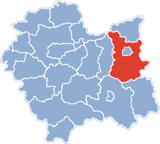
Żurowa is a village in the administrative district of Gmina Szerzyny, within Tarnów County, Lesser Poland Voivodeship, in southern Poland. It lies approximately 8 kilometres (5 mi) west of Szerzyny, 26 km (16 mi) south-east of Tarnów, and 92 km (57 mi) east of the regional capital Kraków.
Zdrochec is a village in the administrative district of Gmina Radłów, within Tarnów County, Lesser Poland Voivodeship, in southern Poland. It lies approximately 6 kilometres (4 mi) north of Radłów, 17 km (11 mi) north-west of Tarnów, and 65 km (40 mi) east of the regional capital Kraków.
Miedzechów is a village in the administrative district of Gmina Jasieniec, within Grójec County, Masovian Voivodeship, in east-central Poland. It lies approximately 11 kilometres (7 mi) east of Grójec and 43 km (27 mi) south of Warsaw.