Przypust is a village in the administrative district of Gmina Waganiec, within Aleksandrów County, Kuyavian-Pomeranian Voivodeship, in north-central Poland. It lies 4 kilometres (2 mi) east of Waganiec, 15 km (9 mi) east of Aleksandrów Kujawski, and 31 km (19 mi) south-east of Toruń.

Stare Masiewo is a village in the administrative district of Gmina Narewka, within Hajnówka County, Podlaskie Voivodeship, in north-eastern Poland, close to the border with Belarus. It lies approximately 10 kilometres (6 mi) east of Narewka, 25 km (16 mi) east of Hajnówka, and 60 km (37 mi) south-east of the regional capital Białystok.
Kipszna is a village in the administrative district of Gmina Ciężkowice, within Tarnów County, Lesser Poland Voivodeship, in southern Poland. It lies approximately 5 kilometres (3 mi) west of Ciężkowice, 27 km (17 mi) south of Tarnów, and 75 km (47 mi) south-east of the regional capital Kraków.
Lubcza is a village in the administrative district of Gmina Ryglice, within Tarnów County, Lesser Poland Voivodeship, in southern Poland. It lies approximately 10 kilometres (6 mi) east of Ryglice, 25 km (16 mi) south-east of Tarnów, and 97 km (60 mi) east of the regional capital Kraków.
Tarnowiec is a village in the administrative district of Gmina Tarnów, within Tarnów County, Lesser Poland Voivodeship, in southern Poland. It lies approximately 6 kilometres (4 mi) south of Tarnów and 76 km (47 mi) east of the regional capital Kraków.
Bobrowniki Małe is a village in the administrative district of Gmina Wierzchosławice, within Tarnów County, Lesser Poland Voivodeship, in southern Poland. It lies approximately 8 kilometres (5 mi) west of Tarnów and 69 km (43 mi) east of the regional capital Kraków.
Olszyny is a village in the administrative district of Gmina Wojnicz, within Tarnów County, Lesser Poland Voivodeship, in southern Poland. It lies approximately 10 kilometres (6 mi) south of Wojnicz, 22 km (14 mi) south-west of Tarnów, and 66 km (41 mi) east of the regional capital Kraków.
Sukmanie is a village in the administrative district of Gmina Wojnicz, within Tarnów County, Lesser Poland Voivodeship, in southern Poland. It lies approximately 8 kilometres (5 mi) south of Wojnicz, 20 km (12 mi) south-west of Tarnów, and 66 km (41 mi) east of the regional capital Kraków.
Więckowice is a village in the administrative district of Gmina Wojnicz, within Tarnów County, Lesser Poland Voivodeship, in southern Poland. It lies approximately 4 kilometres (2 mi) south of Wojnicz, 18 km (11 mi) south-west of Tarnów, and 65 km (40 mi) east of the regional capital Kraków.
Wielka Wieś is a village in the administrative district of Gmina Wojnicz, within Tarnów County, Lesser Poland Voivodeship, in southern Poland. It lies approximately 4 kilometres (2 mi) south of Wojnicz, 18 km (11 mi) south-west of Tarnów, and 65 km (40 mi) east of the regional capital Kraków.
Bieśnik is a village in the administrative district of Gmina Zakliczyn, within Tarnów County, Lesser Poland Voivodeship, in southern Poland. It lies approximately 4 kilometres (2 mi) south of Zakliczyn, 28 km (17 mi) south-west of Tarnów, and 68 km (42 mi) south-east of the regional capital Kraków.
Kończyska is a village in the administrative district of Gmina Zakliczyn, within Tarnów County, Lesser Poland Voivodeship, in southern Poland. It lies approximately 2 kilometres (1 mi) south of Zakliczyn, 26 km (16 mi) south-west of Tarnów, and 68 km (42 mi) east of the regional capital Kraków.
Lusławice is a village in the administrative district of Gmina Zakliczyn, within Tarnów County, Lesser Poland Voivodeship, in southern Poland. It lies approximately 1 kilometre (1 mi) south-west of Zakliczyn, 25 km (16 mi) south-west of Tarnów, and 68 km (42 mi) east of the regional capital Kraków.
Roztoka is a village in the administrative district of Gmina Zakliczyn, within Tarnów County, Lesser Poland Voivodeship, in southern Poland. It lies approximately 2 kilometres (1 mi) north of Zakliczyn, 23 km (14 mi) south-west of Tarnów, and 67 km (42 mi) east of the regional capital Kraków.
Stróże is a village in the administrative district of Gmina Zakliczyn, within Tarnów County, Lesser Poland Voivodeship, in southern Poland. It lies approximately 6 kilometres (4 mi) west of Zakliczyn, 29 km (18 mi) south-west of Tarnów, and 64 km (40 mi) south-east of the regional capital Kraków.

Otfinów is a village in the administrative district of Gmina Żabno, within Tarnów County, Lesser Poland Voivodeship, in southern Poland. It lies approximately 8 kilometres (5 mi) north-west of Żabno, 22 km (14 mi) north-west of Tarnów, and 65 km (40 mi) east of the regional capital Kraków.

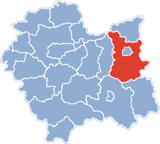
Szerzyny is a village in Tarnów County, Lesser Poland Voivodeship, in southern Poland. It is the seat of the gmina called Gmina Szerzyny. It lies approximately 31 kilometres (19 mi) south-east of Tarnów and 99 km (62 mi) east of the regional capital Kraków.
Wielgołęka is a village in the administrative district of Gmina Gołymin-Ośrodek, within Ciechanów County, Masovian Voivodeship, in east-central Poland. It lies approximately 19 kilometres (12 mi) east of Ciechanów and 67 km (42 mi) north of Warsaw.
Żabowo is a village in the administrative district of Gmina Zawidz, within Sierpc County, Masovian Voivodeship, in east-central Poland. It lies approximately 3 kilometres (2 mi) east of Zawidz, 18 km (11 mi) south-east of Sierpc, and 100 km (62 mi) north-west of Warsaw.
Lusławice is a village in the administrative district of Gmina Zakliczyn, within Tarnów County, Lesser Poland Voivodeship, in southern Poland. It lies approximately 1 kilometre (1 mi) south-west of Zakliczyn, 25 km (16 mi) south-west of Tarnów, and 68 km (42 mi) east of the regional capital Kraków.