
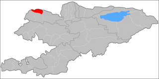
Issyk-Kul Region is one of the regions of Kyrgyzstan. Its capital is Karakol. It is surrounded by Almaty Region, Kazakhstan (north), Chuy Region (west), Naryn Region (southwest) and Xinjiang, China (southeast). It takes its name from Lake Issyk-Kul, the world's second-largest high altitude lake. Its total area is 43,735 km2 (16,886 sq mi). The resident population of the region was 501,933 as of January 2021. The region has a sizeable Russian minority.

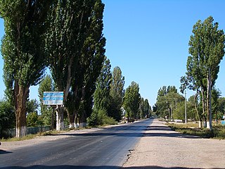
Cholpon-Ata is a resort town on the northern shore of Lake Issyk-Kul in Kyrgyzstan with a population of 14,237 (2021). It is the administrative center of the Issyk-Kul District of Issyk-Kul Region; this district occupies most of the lake's north shore. To the west along highway A363 is Tamchy and to the east, Bosteri.

Ysyk-Ata District is one of the eight districts of the Chuy Region in northern Kyrgyzstan with an area of 2,415 square kilometres (932 sq mi). The district's resident population was 154,340 in 2021. Since 1998, when the former Kant District was merged into Ysyk-Ata District, the administrative center of the district is the city of Kant. The district is located on the southern side of the river Chuy, about halfway between the national capital Bishkek and the former regional capital Tokmok.
Tamchy is a village in the Issyk-Kul District of the Issyk-Kul Region of Kyrgyzstan. Its population was 2,412 in 2021.

Kosh-Köl is a village in the Issyk-Kul Region of Kyrgyzstan. The village name has also been transliterated as Kosh-Kël' or Kosh-Kel'. It is part of the Issyk-Kul District. Its population was 588 in 2021.

Chok-Tal is a village in the Issyk-Kul District of the Issyk-Kul Region of Kyrgyzstan. Its population was 1,910 in 2021. It is located on the northern shore of Lake Issyk Kul between Tamchy and Cholpon Ata.

Bosteri is a village in the Issyk-Kul Region of Kyrgyzstan. It is part of the Issyk-Kul District. Its population was 8,908 in 2021. The town is entirely devoted to mass tourism. There are soviet-era hotels and sanitoria. To the west along highway A363 is Cholpon-Ata, and to the east Korumdu.
Cholpon is a village in the Ak-Suu District of Issyk-Kul Region of Kyrgyzstan. Its population was 1,687 in 2021.

Ak-Suu is a district of Issyk-Kul Region in eastern Kyrgyzstan. The administrative center lies at the village Teploklyuchenka. Its area is 9,917 square kilometres (3,829 sq mi), and its resident population was 69,439 in 2021.

Issyk-Kul District is a district of Issyk-Kul Region in north-eastern Kyrgyzstan. The seat lies at Cholpon-Ata. Its area is 3,603 square kilometres (1,391 sq mi), and its resident population was 84,876 in 2021.

Chatkal is a district of Jalal-Abad Region in western Kyrgyzstan. The administrative seat lies at Kanysh-Kyya. Its area is 4,608 square kilometres (1,779 sq mi), and its resident population was 28,625 in 2021.

Toguz-Toro is a district of Jalal-Abad Region in western Kyrgyzstan. The administrative seat lies at Kazarman. Its area is 3,816 square kilometres (1,473 sq mi), and its resident population was 25,497 in 2021.

Toktogul is a district of Jalal-Abad Region in western Kyrgyzstan. The administrative seat lies at Toktogul. Its area is 7,815 square kilometres (3,017 sq mi), and its resident population was 103,310 in 2021.

At-Bashy is a district of Naryn Region in Kyrgyzstan. The administrative center is at At-Bashy. Its area is 15,354 square kilometres (5,928 sq mi), and its resident population was 55,771 in 2021. The mountain lake Chatyr-Kul lies in the southwestern part of the district.

Kochkor is a district of Naryn Region in northern-central Kyrgyzstan. The administrative seat lies at Kochkor. Its area is 5,868 km2 (2,266 sq mi), and its resident population was 67,363 in 2021.

Bakay-Ata is a district of Talas Region in north-western Kyrgyzstan. Its area is 2,928 square kilometres (1,131 sq mi), and its resident population was 53,359 in 2021. The administrative seat lies at Bakay-Ata.
Manas is a district of Talas Region in north-western Kyrgyzstan. Its area is 1,198 square kilometres (463 sq mi), and its resident population was 37,505 in 2021. The administrative seat lies at Pokrovka.
Kulundu is a village in the Batken Region of Kyrgyzstan. It is part of the Leylek District. Its population was 8,250 in 2021.
Ara-Köl is a village in Cholpon rural community of Kochkor District of Naryn Region of Kyrgyzstan. Its population was 1,028 in 2021.
Aral is a village in Kara-Daryya rural community, in the western part of the Suzak District, Jalal-Abad Region, Kyrgyzstan. Its population was 6,574 in 2021.

