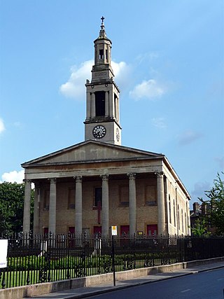
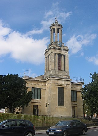
Christ Church in Gipsy Hill is an Anglican Church in the London Borough of Lambeth. The remaining part of the original Victorian church building, the tower, which is now a private dwelling is a Grade II Listed Building[1] and occupies a prominent position, the tower being a notable landmark in the area.
During the first half of the 19th century, the area around Gipsy Hill was sparsely populated, much of it having been part of woodland. The relatively few houses included a mixture of modest cottages and villas for the well-to-do. The opening of the Crystal Palace at Sydenham in 1854 and of Gipsy Hill railway station two years later was followed by considerable residential development in the vicinity.
The parish of Christ Church, Gipsy Hill was formed from the south-eastern part of the parish of St Luke's, West Norwood. In 1862, a temporary iron church with seating for 500 persons was opened on the west side of Gipsy Hill opposite Camden Hill Road. This was replaced by a permanent structure a short distance to the north, on a site at the southern corner of Gipsy Hill and Highland Road that had been given by the Ecclesiastical Commissioners. Construction began in 1866 and the permanent church was consecrated on 5 June 1867.[2]
In 1886, the population of the parish amounted to 4,668 and a total of three clergy ministered at Christ Church. The total (morning and evening) attendance as a proportion of the parochial population at that time stood at 33.3%.[3] In 1901, the population of the parish stood at 5,338. In the following year, two clergymen were in post and attendance at services represented 28.0% of the parochial population.[4]
For most of its history, there has been a daughter church in the parish. St Jude's mission church was built at Berridge Road in 1880, to a design by Frederic W. Ledger. The building was closed in the 1960s and subsequently demolished. Berridge Road Community Centre, which was opened in 1995, was for some years used for worship.[5]
Based on statistics from the UK census, the Diocese of Southwark estimates the population of Christ Church parish was 6,200 in 2001 and 6,300 in 2011.[6]
Building
Tower of the Victorian building at Christ Church Gipsy Hill.
Christ Church is Grade II listed building[7] standing in a prominent position on the west side of Gipsy Hill immediately north of its junction with Highland Road. The church that was consecrated in 1867 was designed by John Giles of Giles, Gough and Trollope. A large ragstone edifice with slated roofs, it consisted of a nave, aisles and a short apsidal chancel. Only 40 feet of the tower were included at that stage. Further building work in 1889 completed the tower and added a vestry and porch.[8] The building was listed as of special architectural or historic interest in 1981 and the description on the English Heritage website relates to its condition at that time.[1]
The majority of the Victorian building was destroyed by fire in 1982, almost the only fabric remaining from the 19th century being the tower. A new church building, designed by Brian Drury, was erected on the cleared site, providing a hexagonal worship area that connects directly to an entrance lobby and to the Goodliffe Hall, a 1960s structure that also survived the conflagration. The new building is of reinforced concrete structure, with timber roof trusses and is entered from Highland Road.[9]
The Victorian church tower is of four stages with a short pyramidical spire and angle turrets. Since the fire in 1982, it has been extended, supplied with a lift and converted into a very unusual detached house called “Highland Tower”.[10] Because of its size and commanding position on the upper part of a steep hill, this tower is a notable landmark.
↑ Sheppard, F. H. W., ed. (1956). "Norwood: Churches". Survey of London: volume 26: Lambeth: Southern area. Institute of Historical Research. Retrieved 23 December 2013.
↑ Cox, Jeffrey (1982). The English Churches in a Secular Society - Lambeth, 1870-1930. Oxford: Oxford University Press. p.294. ISBN0195030192.
↑ Cox, Jeffrey (1982). The English Churches in a Secular Society - Lambeth, 1870-1930. Oxford: Oxford University Press. p.286. ISBN0195030192.
The London Borough of Southwark in South London forms part of Inner London and is connected by bridges across the River Thames to the City of London and London Borough of Tower Hamlets. It was created in 1965 when three smaller council areas amalgamated under the London Government Act 1963. All districts of the area are within the London postal district. It is governed by Southwark London Borough Council.
Crystal Palace is in South London, and named after the Crystal Palace Exhibition building which stood in the area from 1854, until it was destroyed by fire in 1936. About 7 miles (11 km) southeast of Charing Cross, it includes one of the highest points in London, at 367 feet (112 m), offering views over the capital.
Dulwich is an area in south London, England. The settlement is mostly in the London Borough of Southwark, with parts in the London Borough of Lambeth, and consists of Dulwich Village, East Dulwich, West Dulwich, and the Southwark half of Herne Hill. Dulwich lies in a valley between the neighbouring districts of Camberwell, Crystal Palace, Denmark Hill, Forest Hill, Peckham, Sydenham Hill, and Tulse Hill.
Lambeth is a London borough in South London, England, which forms part of Inner London. Its name was recorded in 1062 as Lambehitha and in 1255 as Lambeth. The geographical centre of London is at Frazier Street near Lambeth North tube station, though nearby Charing Cross on the other side of the Thames in the City of Westminster is traditionally considered the centre of London.
West Norwood is a largely residential area of south London within the London Borough of Lambeth, located 5.4 miles (8.7 km) south south-east of Charing Cross. The centre of West Norwood sits in a bowl surrounded by hillsides on its east, west and south sides. From many parts of the area, distant views can be seen, of places such as the City of London, Canary Wharf and Crystal Palace.
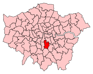
Lambeth is a district in South London, England, in the London Borough of Lambeth. Lambeth was an ancient parish in the county of Surrey. It is situated 1 mile (1.6 km) south of Charing Cross, across the river from Westminster Palace. The population of the London Borough of Lambeth was 303,086 in 2011. The area experienced some slight growth in the medieval period as part of the manor of Lambeth Palace. By the Victorian era the area had seen significant development as London expanded, with dense industrial, commercial and residential buildings located adjacent to one another. The changes brought by World War II altered much of the fabric of Lambeth. Subsequent development in the late 20th and early 21st centuries has seen an increase in the number of high-rise buildings. The area is home to the International Maritime Organization. Lambeth is home to one of the largest Portuguese-speaking communities in the UK, and Portuguese is the second most commonly spoken language in Lambeth after English.
Lambeth was a civil parish and metropolitan borough in south London, England. It was an ancient parish in the county of Surrey. The parish was included in the area of responsibility of the Metropolitan Board of Works in 1855 and became part of the County of London in 1889. The parish of Lambeth became a metropolitan borough in 1900, following the London Government Act 1899, with the parish vestry replaced by a borough council.
Herne Hill is a district in South London, approximately four miles from Charing Cross and bordered by Brixton, Camberwell, Dulwich, and Tulse Hill. It sits to the north and east of Brockwell Park and straddles the boundary between the boroughs of Lambeth and Southwark. There is a road of the same name in the area, as well as a railway station.
The Diocese of Southwark is one of the 42 dioceses of the Church of England, part of the worldwide Anglican Communion. The diocese forms part of the Province of Canterbury in England. It was created on 1 May 1905 from part of the ancient Diocese of Rochester that was served by a suffragan bishop of Southwark (1891–1905). Before 1877 most of the area was part of the Diocese of Winchester, some being part of the Diocese of London.
Dulwich and West Norwood is a constituency in South London created in 1997. It has been represented by Helen Hayes of Labour since her election in 2015.
Gipsy Hill in south London is a hilly and leafy neighbourhood spanning the southern parts of the London Boroughs of Lambeth and Southwark characterised for its stunning views of the City of London and Dulwich.
The Elmgreen School is a coeducational secondary school and sixth form located in the West Norwood area of the London Borough of Lambeth, England. It was the first Parent Promoted secondary school to be created in the UK under the School Standards and Framework Act 1998.
All Saints' Church is a Church of England parish church in West Dulwich, South London. It is a red brick building designed in a Gothic Revival style by George Fellowes Prynne and built 1888–91. It is Grade I listed.
St Luke's Church in West Norwood is an Anglican church that worships in a Grade II* listed building. It stands on a prominent triangular site at the south end of Norwood Road, where the highway forks to become Knights Hill and Norwood High Street.
Christ Church, Southwark, is a church of the Anglican denomination situated on the west side of Blackfriars Road, London. At the time of the foundation there was no bridge at Blackfriars and so no major road connecting the area to the south or to the City.
Francis Octavius Bedford (1784–1858) was an English ecclesiastical architect, who designed four Greek Revival churches in south London during the 1820s. He later worked in the Gothic style.
St Peter's Church is an Anglican church in the London Borough of Lambeth. It is a Grade II* listed building and occupies a prominent position in Leigham Court Road, Streatham.
St Matthew's Church is a Church of England church in the London Borough of Lambeth. It is a Grade II* listed building which occupies a prominent position at the junction of Brixton Road, Brixton Hill and Effra Road. The church was constructed following the Church Building Act 1818 and was consecrated in 1824.
Holy Trinity Church, Trinity Rise, in the Tulse Hill area of the London Borough of Lambeth, is a Grade II Listed Building
St Leonard's Church is a Church of England parish church in the London Borough of Lambeth. It is a Grade II listed building and occupies a prominent position on the west side of Streatham High Road, at its junction with Tooting Bec Gardens and Mitcham Lane.
This page is based on this Wikipedia article Text is available under the CC BY-SA 4.0 license; additional terms may apply. Images, videos and audio are available under their respective licenses.