Related Research Articles

Talbot County is a county located in the west central portion of the U.S. state of Georgia. The 2020 census showed a population of 5,733. The county seat and largest city is Talbotton.
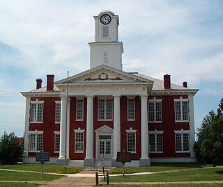
Stewart County is a county located in the west central portion of the U.S. state of Georgia. As of the 2020 census, the population was 5,314. The county seat is Lumpkin. The county was created on December 23, 1830.

Muscogee County is a county located on the central western border of the U.S. state of Georgia named after the Muscogee that originally inhabited the land with its western border with the state of Alabama that is formed by the Chattahoochee River. As of the 2020 census, the population was 206,922. Its county seat and only city is Columbus, with which it has been a consolidated city-county since the beginning of 1971.

Marion County is a county located in the west central portion of the U.S. state of Georgia. As of the 2020 census, the county had a population of 7,498. The county seat is Buena Vista. The county was created on December 14, 1827. The county was named for General Francis Marion of South Carolina.

Harris County is a county located in the west-central portion of the U.S. state of Georgia; its western border with the state of Alabama is formed by the Chattahoochee River. As of the 2020 census, the population was 34,668. The county seat is Hamilton. The largest city in the county is Pine Mountain, a resort town that is home to the Franklin D. Roosevelt State Park. Harris County was created on December 14, 1827, and named for Charles Harris, a Georgia judge and attorney. Harris County is part of the Columbus, GA-AL metropolitan area and has become a popular suburban and exurban destination of residence for families relocating from Columbus. Because of this, Harris has become the sixth-wealthiest county in Georgia in terms of per capita income and the wealthiest in the state outside of Metro Atlanta.

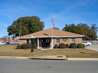
Chattahoochee County, also known as Cusseta-Chattahoochee County, is a county located on the western border in central Georgia. As of the 2020 census, the population was 9,565. The county seat is Cusseta, with which the county shares a consolidated city-county government. The city of Cusseta remains a geographically distinct municipality within Chattahoochee County. The county was created on February 13, 1854.

Cusseta is a city in Chattahoochee County, Georgia, United States. It is part of the Columbus, Georgia-Alabama metropolitan statistical area. The population was 9,565 in 2020. The city is the county seat of Chattahoochee County, with which it shares a consolidated city-county government. Despite this, Cusseta is not coterminous with the county; it remains a geographically distinct municipality within the county.

Waverly Hall is a town in Harris County, Georgia, United States. It is part of the Columbus, Georgia-Alabama metropolitan statistical area. The population was 638 in 2020.

Greenville is a city and the county seat of Meriwether County, Georgia, United States. The population was 794 at the 2020 census, down from 876 in 2010. The city is located 60 miles (97 km) southwest of Atlanta and is part of the Atlanta metropolitan area.
Lumpkin is a city and county seat of Stewart County, Georgia, United States. Per the 2020 census, the population was 891.

Geneva is a town in Talbot County, Georgia, United States. The population was 75 at the 2020 census.

Junction City is a town in Talbot County, Georgia, United States. The population was 138 at the 2020 census.

Talbotton is a city in Talbot County, Georgia, United States. The population was 970 at the 2010 census. The city is the county seat of Talbot County.
Butler is the county seat of Taylor County, Georgia, United States. Its population was 1,972 at the 2010 census, and 1,881 in 2020.

A. J. McClung Memorial Stadium is a 15,000-seat sports stadium located in Columbus, Georgia. It was the site of football games between the Georgia Bulldogs and the Auburn Tigers from 1916 until 1958. The stadium now hosts the Fort Valley State–Albany State and the Tuskegee–Morehouse rivalry games, as well local youth football and soccer and high school football games.
Upatoi is a community in northeastern Muscogee County, Georgia, United States. Upatoi was annexed by the city of Columbus, Georgia, in 1971 as part of the consolidation of the city and county governments. The community is on Georgia Route 22 and U.S. Route 80 approximately 15 miles east of Columbus. Upatoi Creek is on the southern boundary of Muscogee County approximately three miles south of the community. The ZIP Code for Upatoi is 31829.
32.516°N 84.885°W
Upatoi Creek is a 35.5-mile-long (57.1 km) river in western Georgia, just outside Columbus. It runs from Upatoi, through South Columbus, and to the Chattahoochee River.
Bibb City was a city in west-central Georgia, United States. It had been the company town of the Bibb Manufacturing Company in Muscogee County, and had a population of 510 in its last official U.S. census (2000). The entire city area, consisting of historic Columbus Mill and the associated mill village owned by the company, is now part of the consolidated city-county of Columbus. It is listed in the National Register of Historic Places as Bibb City Historic District.

The Aflac Building, located in Columbus, Georgia, was ordered in late November 1974, the groundbreaking ceremony took place January 4, 1975, and the tower was complete and occupied on December 19, 1975. The tower is the tallest building in the U.S. state of Georgia outside of the Atlanta Metropolitan Area, Savannah, and Augusta. It Is located about 1 mile east of downtown. The building is 278 feet tall. It serves as the headquarters for Aflac, an insurance company. The tower was to modernize the downtown Columbus area along with the Columbus government center built a year earlier.
References
- ↑ U.S. Geological Survey Geographic Names Information System: Christopher
- ↑ Krakow, Kenneth K. (1975). Georgia Place-Names: Their History and Origins (PDF). Macon, GA: Winship Press. p. 44. ISBN 0-915430-00-2.
Municipalities and communities of Chattahoochee County, Georgia, United States | ||
|---|---|---|
| City |  | |
| Former CDP | ||
| Ghost towns | ||
32°19′38″N84°43′50″W / 32.32722°N 84.73056°W
| | This Chattahoochee County, Georgia state location article is a stub. You can help Wikipedia by expanding it. |