Catford is a district in south east London, England, and the administrative centre of the London Borough of Lewisham. It is southwest of Lewisham itself, mostly in the Rushey Green and Catford South wards. The population of Catford, including the Bellingham, London neighbourhood, was 44,905 as of 2011.

Walsall is a market town and administrative centre in the West Midlands County, England. Historically part of Staffordshire, it is located 9 miles (14 km) north-west of Birmingham, 7 miles (11 km) east of Wolverhampton and 9 miles (14 km) from Lichfield.

Aldridge is a town and former civil parish in the Walsall borough, West Midlands, England. It is historically a village that was part of Staffordshire until 1974.

Halesowen is a market town in the Metropolitan Borough of Dudley, in the county of West Midlands, England.

Epsom and Ewell is a local government district with borough status and unparished area in Surrey, England, covering the towns of Epsom and Ewell. The borough was formed as an urban district in 1894, and was known as Epsom until 1934. It was made a municipal borough in 1937. The district was considered for inclusion in Greater London in 1965 but was left unaltered by the London Government Act 1963 and the Local Government Act 1972 in 1974. However, despite being outside modern Greater London the borough was in the Metropolitan Police District until it was transferred to Surrey Police in 2000. In the May 2019 elections, the borough was held by the Epsom and Ewell Residents Association with 32 seats, Labour with 3 seats, Liberal Democrats with 2 seats, and Conservatives with 1 seat.

North Melbourne is an inner-city suburb in Melbourne, Victoria, Australia, 3 km (1.9 mi) north-west of Melbourne's Central Business District, located within the City of Melbourne local government area. North Melbourne recorded a population of 14,953 at the 2021 census.

Greenvale is a suburb in Melbourne, Victoria, Australia, 20 km (12 mi) north of Melbourne's Central Business District, located within the City of Hume local government area. Greenvale recorded a population of 21,274 at the 2021 census.

Carlton is an inner-city suburb in Melbourne, Victoria, Australia, 3 km north of Melbourne's Central Business District, located within the City of Melbourne local government area. Carlton recorded a population of 16,055 at the 2021 census.
Bloxwich is a market town in the Metropolitan Borough of Walsall, West Midlands, England, situated in the north of the borough and forming part of the Staffordshire/West Midlands border.
Sundorne is a suburb of the town of Shrewsbury, county town of Shropshire. It is located 2 km north of the town centre. The B5062 road begins at Heathgates Roundabout and is called Sundorne Road in the Sundorne area, before crossing the Shrewsbury by-pass at Sundorne Roundabout and heading east towards Newport. Population : 5123, reducing to 3,957 at the 2011 census.

Norlane is a northern suburb of Geelong, in Victoria, Australia. Norlane is bordered in the south by Cowies Creek, in the north by Cox Road, in the west by Thompson Road and in the east by Station Street. It is about 7 km from the Geelong central business district and approximately 70 km from the state capital, Melbourne. It is about one kilometre from the shore of Corio Bay. At the 2016 census, Norlane had a population of 8,306.

Paddington is an upscale inner-city area of Sydney, in the state of New South Wales, Australia. Located 3 kilometres (1.9 mi) east of the Sydney central business district, Paddington lies across two local government areas. The portion south of Oxford Street lies within the City of Sydney, while the portion north of Oxford Street lies within the Municipality of Woollahra. It is often colloquially referred to as "Paddo".

Caldmore is a suburb of Walsall in the West Midlands, England. It is a historic village formerly in Staffordshire.

Mosborough is an electoral ward of the City of Sheffield, England, in the eastern part of the city, on the border with Rotherham. The population in 2011 was 17,097. It is one of the wards that make up the Sheffield South East constituency.
Forestville is a suburb of Northern Sydney, in the state of New South Wales, Australia. Forestville is 12 kilometres north of the Sydney central business district in the local government area of Northern Beaches Council. Forestville is part of the Forest District.

Hackney Central is a sub-district of Hackney in the London Borough of Hackney in London, England and is four miles (6.4 km) northeast of Charing Cross.

Bonython is a suburb of Tuggeranong, a township in southern Canberra, capital city of Australia.

Rushall is a suburb and historic village in the Metropolitan Borough of Walsall in the West Midlands County, England, centred on the main road between Walsall and Lichfield. It is mentioned in the Domesday Book but has mostly developed since the 1920s. Rushall was historically a part of the county of Staffordshire before it was incorporated with much of the old Aldridge-Brownhills Urban District into the modern-day Walsall district.
Gleadless Valley is a housing estate and electoral ward of the City of Sheffield in England. The population of the ward at the 2011 Census was 21,089. It lies 2.5 miles (4.0 km) south-southeast of the city centre. Formerly a rural area, Gleadless Valley was developed as a large housing project with around 4000 dwellings by Sheffield City Council between 1955 and 1962. It is an area of undulating land drained by the Meers Brook, which has its source on the high ground in the woodland at Gleadless. Adjacent are Gleadless to the east, Norton to the south-west, Heeley to the west and Arbourthorne to the north.
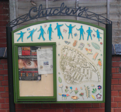
The Chuckery was a cricket and football ground in the Chuckery area of Walsall, England. It was the home ground of the Walsall Swifts and Walsall Town football clubs until they merged in 1888, after which it was used by the new Walsall Town Swifts club.