Sinchi Roca, Sinchi Rocca, Cinchi Roca, Sinchi Ruq'a or Sinchi Ruq'a Inka was the second Sapa Inca of the Kingdom of Cusco and a member of the Hurin dynasty.

The Chachapoyas, also called the "Warriors of the Clouds", was a culture of the Andes living in the cloud forests of the southern part of the Department of Amazonas of present-day Peru. The Inca Empire conquered their civilization shortly before the Spanish conquest in the 16th century. At the time of the arrival of the conquistadors, the Chachapoyas were one of the many nations ruled by the Incas, although their incorporation had been difficult due to their constant resistance to Inca troops.
Pedro Cieza de León was a Spanish conquistador and chronicler of Peru and Popayán. He is known primarily for his history and description of Peru, Crónicas del Perú. He wrote this book in four parts, but only the first was published during his lifetime; the remaining sections were not published until the 19th and 20th centuries.

Coricancha, Koricancha, Qoricancha or Qorikancha was the most important temple in the Inca Empire. It is located in Cusco, Peru, which was the capital of the empire.

A tambo was an Incan structure built for administrative and military purposes. Found along Incan roads, tambos typically contained supplies, served as lodging for itinerant state personnel, and were depositories of quipu-based accounting records. Individuals from nearby communities within the Inca empire were conscripted to serve in the tambos, as part of the mit'a labor system.

Chucuito District is one of the districts of the Puno Province in the Puno Region in Peru.

Chucuito Province is a province of the Puno Region in Peru. The capital of the province is the city of Juli.
Desaguadero District is one of seven districts of the province Chucuito in Puno Region, Peru.
Pomata District is one of seven districts of the Chucuito Province in Puno Region, Peru.
Zepita is one of seven districts of the Chucuito Province in Puno Region, Peru.

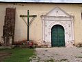
Juli District is one of seven districts of the Chucuito Province in Puno Region, Peru.
Guaqui is a railhead and port in Bolivia on Lake Titicaca. A ferry connects with the Peruvian railhead and port on Puno. It served as location of Inca ruins prior to the arrival of the Spanish. The towns current church sites on what was the ancient ruins.
Ayaviri or Ayawiri (Aymara) is a town in Southern Peru, capital of the province Melgar in the region Puno. According to the 2007 Peruvian census, Ayaviri has a population of 22,667 people. Local festivities of note include the Festividad de Calendaria on January 24 and the Aniversario de la Provincia on October 25.

Desaguadero or Chaka Marka is a town on the Bolivian-Peruvian border. On the Bolivian side it is situated in the La Paz Department, Ingavi Province, Desaguadero Municipality, Desaguadero Canton. On the Peruvian side it lies in the Puno Region, Chucuito Province, Desaguadero District. Both parts of the town are united by a binational bridge.
Ukumari was an Inca prince and general supporting the cause of Atahualpa in the Inca Civil War.
Pedro de Candia was a Greek-born explorer and cartographer the son of a Venetian family at the service of the Kingdom of Spain, an officer of the Royal Spanish Navy that under the Spanish Crown became a Conquistador, Grandee of Spain, Commander of the Royal Spanish Fleet of the Southern Sea, Colonial Ordinance of Cusco, and then Mayor of Lima between 1534 and 1535. Specialized in the use of firearms and artillery, he was one of the earliers explorers of Panama and the Pacific coastline of Colombia, and finally participated in the conquest of Peru. He was killed in the Battle of Chupas, (Peru), on 16 September 1542, by Diego de Almagro II.

The Lupaca, Lupaka, or Lupaqa people were one of the divisions of the ancestral Aymaras. The Lupaca lived for many centuries near Lake Titicaca in Peru and their lands possibly extended into Bolivia. The Lupacas and other Aymara peoples formed powerful kingdoms after the collapse of the Tiwanaku Empire in the 11th century. In the mid 15th century they were conquered by the Inca Empire and in the 1530s came under the control of the Spanish Empire.

`Inca Uyo is an archaeological site of cut-stone structures located near the town of Chucuito, Peru. The site is an arrangement of carved stones protruding from the earth within a walled rectangular ruin.
Inka Tunuwiri is an archaeological site in Peru. It is located in the Puno Region, Puno Province, between the districts Chucuito and Puno, southeast of the village Ichu. Inka Tunuwiri was declared a National Cultural Heritage (Patrimonio Cultural) of Peru by the National Institute of Culture.

The Aymara kingdoms, Aymara lordships or lake kingdoms were a group of native polities that flourished towards the Late Intermediate Period, after the fall of the Tiwanaku Empire, whose societies were geographically located in the Qullaw. They were developed between 1150 and 1477, before the kingdoms disappeared due to the military conquest of the Inca Empire. But the current Aymara population is estimated at two million located in the countries of Bolivia, Peru, Chile and Argentina. They used the Aymara and Puquina languages.