
The Blang people are an ethnic group. They form one of the 56 ethnic groups officially recognized by the People's Republic of China.

Lhünzhub County, also called Lhundrub or Linzhou County, is a county in Lhasa towards the north-east of the main center of Chengguan, Tibet, China. It covers an area of 4,512 km2 (1,742 sq mi) and as of 2000 had a population of 50,895 people, almost all classified as rural. The southern portion, the Pengbo River Valley, contains fertile arable land, while the colder and more mountainous northern portion primarily supports grazing. The county has many monasteries, including the Reting Monastery.

Xiangxiang is a county-level city under the administration of Xiangtan, Hunan province, China. Located on Central Hunan and the west of Xiangtan, Xiangxiang is bordered by Ningxiang County and Shaoshan City to the north, Xiangtan County to the east, Shuangfeng County to the south, Louxing District of Loudi City to the west, it has an area of 1,912.7 km2 (738.5 sq mi) with a population of rough 850,000. It has 4 subdistricts, 15 towns and 3 townships under its jurisdiction, the government seat is Wangchunmen (望春门街道).

Namling or Namlingxoi is a town and seat of Namling County in the Tibet Autonomous Region of China, about 72 kilometres (45 mi) by road northeast of Shigatse, north of Dobjoi.
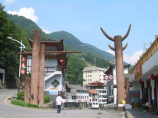
Lhünzhub, or Ganden Chökhor is a small town, the administrative center of Lhünzhub County in the Lhasa Prefecture of Tibet, China. It is located northeast of Lhasa.

Lüchun County is located in Honghe Hani and Yi Autonomous Prefecture, in the south of Yunnan province, China, bordering Vietnam's Lai Châu Province to the south.
Muyu is a town in Shennongjia Forestry District, in the west of Hubei province, People's Republic of China. Located on China National Highway 209, it is the main population and services center of the southern part of the district.

Hutoushan Reservoir is a man made reservoir in Lhünzhub County, Tibet, to the north of the city of Lhasa. It is an important wintering place for black-necked cranes and other migratory birds.
Dzao Min, is a Hmong–Mien language of China. Mao (2004:306) reports a total of more than 60,000 speakers in Liannan County and Yangshan County of Guangdong, and in Yizhang County of Hunan. The speakers from Bapai, Guangdong are also called Bapai Yao (八排瑶族).
Kazi Township is a township of Lhünzhub County, in east-central Tibet Autonomous Region, People's Republic of China, located 8.6 kilometres (5.3 mi) west of the county seat, and about 25 km (16 mi) north of the main urban area of Lhasa As of 2011, it has 6 villages under its administration.
Zhujia is a village in Lhünzhub County in the Lhasa Prefecture of Tibet Autonomous Region, in China. It lies 25.5 kilometres (15.8 mi) by road west of Lhünzhub, near Hutoushan Reservoir. By road it is 90 kilometres (56 mi) from Lhasa, but considerably nearer to the north as the road forks around much further to the east first before approaching Lhünzhub and Zhujia. It appears to have been a township of Lhünzhub County, covering 126 square kilometers, with a population of 4000 at one point, with 12 village committees. However, the National Bureau of Statistics now lists Zhujia as a village and no longer as an official township-level division of Lhünzhub County.
Sadu is a Loloish language of Yuxi, central Yunnan, China.

Hutian Town is a rural town in Xiangxiang City, Xiangtan City, Hunan Province, People's Republic of China.
Jinsou Township is an rural township in the northwest of Xiangxiang City, Hunan Province, People's Republic of China.
The Hani languages are a group of closely related but distinct languages of the Loloish (Yi) branch of the Tibeto-Burman linguistic group. They are also referred to as the Hanoid languages by Lama (2012) and as the Akoid languages by Bradley (2007).

Jiangya Town is an urban town in Cili County, Zhangjiajie, Hunan Province, People's Republic of China.
Xujiafang Township is a rural township in Cili County, Zhangjiajie, Hunan Province, People's Republic of China.
Khabi, also rendered Kabie, is a Southern Loloish language of Yunnan, China. Kabie is spoken in Jiangcheng Hani and Yi Autonomous County, Mojiang Hani Autonomous County, and Lüchun County.
Guozuo is a Southern Loloish language of Yunnan, China. It is spoken in Jinping Miao, Yao, and Dai Autonomous County and Lüchun County, Yunnan.
Chunlian is a subdistrict and the county seat located in the middle south of You County, Hunan, China. it was created by dividing 5 villages and communities of Lianxing Subdistrict on November 13, 2014. The subdistrict has 3 villages and 5 communities under its jurisdiction with an area of 33.74 km2 (13.03 sq mi), as of 2015 end, it has a population of 16,200, its administrative centre was at Chunlian Community (春联社区).

