Church Street, Ribchester

Last updated

Church Street
Church Street, Ribchester.jpg
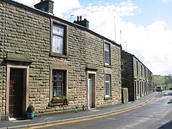
Looking south along Church Street towards the River Ribble
Church Street, Ribchester
Length0.37 mi (0.60 km)
Location Ribchester, Lancashire, England
North endRibchester Road (B6245)

Church Street is an historic street in the English village of Ribchester, Lancashire. Named for St Wilfrid's Church, which is located near the southern end of the street, Church Street runs for about 0.37 miles (0.60 km), from its junction with Ribchester Road (the B6245), to the north, to its terminus on the western banks of the River Ribble, to the south of Ribchester's village centre. Several of its buildings date to the 17th century.

Notable locations

From north to south

Related Research Articles

<span class="mw-page-title-main">Homerton</span> Area of East London, England

Homerton is an area in London, England, in the London Borough of Hackney. It is bordered to the west by Hackney Central, to the north by Lower Clapton, in the east by Hackney Wick, Leyton and by South Hackney to the south. In 2019, it had a population of 14,658 people. In terms of ethnicity it was 43.9% White, 33.0% Black, 10.9% Asian and 7.8% Mixed. It covered an area of 0.830 sq kilometres. Homerton ward on Hackney Borough Council is currently represented by three Labour councillors. There are fifty listed buildings located within the boundaries of the ward.

<span class="mw-page-title-main">Kingsthorpe</span> Suburb in Northampton, England

Kingsthorpe is a suburb and civil parish of Northampton, England. It is situated to the north of Northampton town centre and is served by the A508 and A5199 roads which join at Kingsthorpe's centre. The 2011 Census recorded the population of the district council ward as 4,477.

<span class="mw-page-title-main">Ribchester</span> Human settlement in England

Ribchester is a village and civil parish within the Ribble Valley district of Lancashire, England. It lies on the banks of the River Ribble, six miles (10 km) northwest of Blackburn and twelve miles (19 km) east of Preston.

<span class="mw-page-title-main">Standish, Greater Manchester</span> Human settlement in England

Standish is a village in the Metropolitan Borough of Wigan, Greater Manchester, England. Within the boundaries of the historic county of Lancashire, it is on the A49 road between Chorley and Wigan, near Junction 27 of the M6 motorway. The population of the village was 13,278 in the 2011 census.

<span class="mw-page-title-main">Buildings and architecture of Bristol</span>

Bristol, the largest city in South West England, has an eclectic combination of architectural styles, ranging from the medieval to 20th century brutalism and beyond. During the mid-19th century, Bristol Byzantine, an architectural style unique to the city, was developed, and several examples have survived.

<span class="mw-page-title-main">Grade I listed buildings in Bristol</span>

There are 100 Grade I listed buildings in Bristol, England according to Bristol City Council. The register includes many structures which for convenience are grouped together in the list below.

<span class="mw-page-title-main">Bremetennacum</span> Ruins of a Roman fort in Ribchester, England

Bremetennacum,, or Bremetennacum Veteranorum, was a Roman fort on the site of the present day village of Ribchester in Lancashire, England. The site is a Scheduled Monument.

<span class="mw-page-title-main">Grade II* listed buildings in Greater Manchester</span>

There are 236 Grade II* listed buildings in Greater Manchester, England. In the United Kingdom, the term listed building refers to a building or other structure officially designated as being of special architectural, historical or cultural significance; Grade II* structures are those considered to be "particularly significant buildings of more than local interest". In England, the authority for listing under the Planning Act 1990 rests with English Heritage, a non-departmental public body sponsored by the Department for Culture, Media and Sport.

<span class="mw-page-title-main">St Wilfrid's Church, Melling</span> Church in Lancashire, England

St Wilfrid's Church is in Main Street, Melling, Lancashire, England. It is recorded in the National Heritage List for England as a designated Grade I listed building, and is an active Anglican church in the united benefice of East Lonsdale, the deanery of Tunstall, the archdeaconry of Lancaster and the diocese of Blackburn. Its benefice is combined with those of St Peter, Leck, St John the Baptist, Tunstall, St James the Less, Tatham, the Good Shepherd, Lowgill, and Holy Trinity, Wray.

<span class="mw-page-title-main">St John the Baptist's Church, Tunstall</span> Church in Lancashire, England

St John the Baptist Church is located to the northeast of the village of Tunstall, Lancashire, England. It is an active Anglican parish church in the united benefice of East Lonsdale, in the deanery of Tunstall, the archdeaconry of Lancaster and the diocese of Blackburn. The benefice of East Lonsdale combines this church with St Peter, Leck, St Wilfrid, Melling, St James the Less, Tatham, The Good Shepherd, Lowgill, and Holy Trinity, Wray. The church is recorded in the National Heritage List for England as a designated Grade I listed building. Services are usually at 11:00 on 2nd & 4th Sundays, in rota with the sister church at Leck.

<span class="mw-page-title-main">Catholic Church of St Oswald and St Edmund Arrowsmith</span> Church in Ashton-in-Makerfield, United Kingdom

<span class="mw-page-title-main">Osbaldeston</span> Human settlement in England

Osbaldeston is a village and civil parish in Lancashire, England about 3+14 miles (5.2 km) north-west of Blackburn and 7 miles (11.3 km) east of Preston. The population of the civil parish as taken at the 2011 census was 185.

<span class="mw-page-title-main">Grade II* listed buildings in Brighton and Hove</span>

There are 72 Grade II* listed buildings in the city of Brighton and Hove, England. The city, on the English Channel coast approximately 52 miles (84 km) south of London, was formed as a unitary authority in 1997 by the merger of the neighbouring towns of Brighton and Hove. Queen Elizabeth II granted city status in 2000.

<span class="mw-page-title-main">St Wilfrid's Church, Ribchester</span> Church in Lancashire, England

St Wilfrid's Church is an Anglican church in the village of Ribchester in Lancashire, England that is situated close to the site of a Roman fort. It is an active parish church in the Diocese of Blackburn. It is recorded in the National Heritage List for England as a designated Grade I listed building.

<span class="mw-page-title-main">St Saviour's Church, Stydd</span> Church in Lancashire, England

St Saviour's Church is an Anglican chapel in Stydd, a hamlet near Ribchester in Lancashire, England. It has been designated a Grade I listed building by English Heritage.

<span class="mw-page-title-main">St Wilfrid's Church, Halton-on-Lune</span> Church in Lancashire, England

St Wilfrid's Church is an Anglican church in Halton-on-Lune, a village in the English county of Lancashire. It is an active parish church in the Diocese of Blackburn and the archdeaconry of Lancaster. Halton may have been the site of an ancient Anglo-Saxon minster. Of the current structure, the tower dates from the 16th century and the remainder was built 1876–77 by Paley and Austin. The church is recorded in the National Heritage List for England as a designated Grade II listed building.

<span class="mw-page-title-main">Grade I listed buildings in Greater Manchester</span>

There are 48 Grade I listed buildings in Greater Manchester, England. In the United Kingdom, the term listed building refers to a building or other structure officially designated as being of special architectural, historical or cultural significance; Grade I structures are those considered to be "buildings of exceptional interest". In England, the authority for listing under the Planning Act 1990 rests with Historic England, a non-departmental public body sponsored by the Department for Culture, Media and Sport.

Ribchester is a civil parish in Ribble Valley, Lancashire, England. It contains 23 listed buildings that are recorded in the National Heritage List for England. Of these, one is listed at Grade I, the highest of the three grades, one is at Grade II*, the middle grade, and the others are at Grade II, the lowest grade. The parish contains the village of Ribchester, and surrounding countryside. Most of the listed buildings are houses and associated structures, or farmhouses and farm buildings, some of which are in the village, and others are in the rural area. The other listed buildings are two churches, a presbytery, a sundial, a public house with a mounting block outside, a bridge, and almshouses with a wellhead in the grounds.

<span class="mw-page-title-main">The White Bull, Ribchester</span> Pub in Lancashire, England

The White Bull is a public house and inn on Church Street in the English village of Ribchester, Lancashire. It dates to 1707, although an alehouse is believed to have previously stood on the site. It is a Grade II listed building with some unique exterior features.

References

  1. "48, CHURCH STREET, Ribchester - 1308510 | Historic England". historicengland.org.uk. Retrieved 22 September 2022.
  2. "28 AND 29, CHURCH STREET, Ribchester - 1072259 | Historic England". historicengland.org.uk. Retrieved 22 September 2022.
  3. 2 Church Street, Ribchester, Lancashire: Archaeological Watching Brief, October 2006Oxford Archaeology North