Church of Saint Pancras, Widecombe-in-the-Moor

Last updated

St Pancras Church, Widecombe-in-the-Moor St-Pancras-Church-Widecombe-in-the-Moor.jpg
St Pancras Church, Widecombe-in-the-Moor

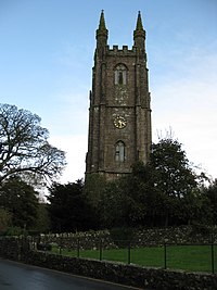
The Church of Saint Pancras is a Church of England church in Widecombe-in-the-Moor, Devon, England. It is also known as the Cathedral of the Moor. The church is Grade I listed. [1]

It has received the nickname "Cathedral of the Moor" because of its 120-foot tower and relatively large capacity for such a small village. The church was originally built in the fourteenth century, in the Perpendicular (late Gothic) style, using locally quarried granite. It was enlarged over the following two centuries, partly on the proceeds of the local tin-mining trade. Inside, the ceiling is decorated with a large number of decorative roof bosses, including the tinner's emblem of a circle of three hares (known locally as the Tinners' Rabbits).

The church was badly damaged in the Great Thunderstorm of 1638, apparently struck by ball lightning. An afternoon service was taking place at the time, and the building was packed with approximately 300 worshippers. Four of them were killed, around 60 injured. According to local legend, the Great Thunderstorm was caused by the village being visited by the Devil. [2]

The size of the parish meant that, for centuries, families were obliged to walk for miles to go to church at Widecombe every Sunday. The task was even more challenging when it came to burying their dead, whose coffins had to be carried over rough ground and both up and down exceptionally steep hills. Halfway up Dartmeet Hill, for example, lies the Coffin Stone, close to the road, where the body would be placed to allow the bearers to take a rest. The rock is split in two along its length. Local legend has it that the body of a particularly wicked man was laid there. God took exception to this, and struck the stone with a thunderbolt, destroying the coffin and splitting the stone in two.

Beatrice Chase, a writer known during the first half of the 20th century for her Dartmoor-based novels, is buried in the churchyard.

Related Research Articles

<span class="mw-page-title-main">Dartmoor</span> National park in South West England

Dartmoor is an upland area in southern Devon, South West England. The moorland and surrounding land has been protected by National Park status since 1951. Dartmoor National Park covers 954 km2 (368 sq mi).

Princetown is a village located within Dartmoor national park in the English county of Devon. It is the principal settlement of the civil parish of Dartmoor Forest.

<span class="mw-page-title-main">Chagford</span> Town in Devon, England

Chagford is a market town and civil parish on the north-east edge of Dartmoor, in Devon, England, close to the River Teign and the A382, 4 miles (6 km) west of Moretonhampstead. The name is derived from chag, meaning gorse or broom, and the ford suffix indicates its importance as a crossing place. At the 2011 Census, it had a population of 1,449.

<span class="mw-page-title-main">Widecombe in the Moor</span> Village in Devon, England

Widecombe in the Moor is a village and large civil parish in Dartmoor National Park in Devon, England. Its church is known as the Cathedral of the Moors on account of its tall tower and its size, relative to the small population it serves. It is a favourite tourist centre, partly for its scenic character and partly for its connection to the popular song "Widecombe Fair".

<span class="mw-page-title-main">Dartmeet</span> Confluence of East and West Dart in Devon, England

Dartmeet is a popular tourist spot in the centre of Dartmoor, Devon, England at grid reference SX672731.

<span class="mw-page-title-main">Warren House Inn</span> Public house on Dartmoor in Devon, England

The Warren House Inn is a remote and isolated public house in the heart of Dartmoor, Devon, England. It is the highest pub in southern England at 1,425 feet (434 m) above sea level. It is located on an ancient road across the moor, about 2 miles (3 km) north east of the village of Postbridge and has been a stopping point for travellers since the middle of the 18th century.

<span class="mw-page-title-main">Ponsworthy</span> Hamlet in Devon, England

Ponsworthy is a hamlet on the eastern side of Dartmoor, Devon, England. It lies in the steep valley of the West Webburn River about 3.5 km (2.2 mi) southwest of the village of Widecombe-in-the-Moor.

Widecombe Fair is an annual fair in England, held in the Dartmoor village of Widecombe-in-the-Moor on the second Tuesday of September. It is well known as the subject of the folk song of the same name, featuring Uncle Tom Cobley and his friends.

<span class="mw-page-title-main">Ilsington</span> Village and civil parish in Devon, England

Ilsington is a village and civil parish situated on the eastern edge of Dartmoor, Devon, England. It is one of the largest parishes in the county, and includes the villages of Ilsington, Haytor Vale, Liverton and South Knighton. The parish is surrounded, clockwise from the north, by the parishes of Bovey Tracey, Teigngrace, Newton Abbot, Ogwell, Bickington, Ashburton, Widecombe-in-the-Moor and Manaton. In 2001 the population of the parish was 2,444, greatly increased from the 886 residents recorded in 1901. The parish is represented in parliament by Mel Stride, as part of the Central Devon constituency.

<span class="mw-page-title-main">The Great Thunderstorm</span>

The Great Thunderstorm of Widecombe-in-the-Moor in Dartmoor, Kingdom of England, took place on Sunday, 21 October 1638, when the church of St Pancras was apparently struck by ball lightning during a severe thunderstorm. An afternoon service was taking place at the time, and the building was packed with approximately 300 worshippers. Four of them were killed, around 60 injured, and the building severely damaged.

<span class="mw-page-title-main">Jay's Grave</span> 18th century landmark on Dartmoor, Devon, South-West England

Jay's Grave is supposedly the last resting place of a suicide victim who is thought to have died in the late 18th century. It has become a well-known landmark on Dartmoor, Devon, in South-West England, and is the subject of local folklore, and several ghost stories.

<span class="mw-page-title-main">Poundsgate</span> Village in Devon, England

Poundsgate is a small village in Dartmoor, Devon, England, located on the road between Ashburton and Princetown.

<span class="mw-page-title-main">Dartmoor tin mining</span>

The tin mining industry on Dartmoor, Devon, England, is thought to have originated in pre-Roman times, and continued right through to the 20th century, when the last commercially worked mine closed in November 1930. From the 12th century onwards tin mining was regulated by a stannary parliament which had its own laws.

<span class="mw-page-title-main">Bovey Tracey</span> Town in Devon, England

Bovey Tracey is a town and civil parish in Devon, England, on the edge of Dartmoor, its proximity to which gives rise to the slogan used on the town's boundary signs, "The Gateway to the Moor". It is often known locally as "Bovey". It is about 10 miles south-west of Exeter and lies on the A382 road, about halfway between Newton Abbot and Moretonhampstead. The village is at the centre of the electoral ward of Bovey. At the 2011 census the population of this ward was 7,721.

<span class="mw-page-title-main">West Bagborough</span> Human settlement in England

West Bagborough is a village and civil parish in Somerset, England, about 5 miles (8.0 km) north of Taunton. In 2011, the village had a population of 358.

St Pancras, St. Pancras or Saint Pancras may refer to:

<span class="mw-page-title-main">Brent Tor</span> Granite tor on Dartmoor in Devon, England

Brent Tor is a tor on the western edge of Dartmoor, approximately four miles (6.5 km) north of Tavistock, rising to 1100 ft (330m) above sea level. The Tor is surmounted by the Church of St Michael, the parish church of the village of Brentor, which lies below the Tor.

<span class="mw-page-title-main">Corpse road</span> Aspect of burial practices

Corpse roads provided a practical means for transporting corpses, often from remote communities, to cemeteries that had burial rights, such as parish churches and chapels of ease. In Britain, such routes can also be known by a number of other names, e.g.: bier road, burial road, coffin line, coffin road, corpse way, funeral road, lych way, lyke way, or procession way. etc. Such "church-ways" have developed a great deal of associated folklore regarding ghosts, spirits, wraiths, etc.

<span class="mw-page-title-main">Doddiscombsleigh</span> Village in Devon, England

Doddiscombsleigh is a small settlement in Devon, England. It is 5 miles (8 km) southwest of the city of Exeter and one mile East of the River Teign and the Teign Valley. Along with a few other places in Devon, it is one of the longest place names in England with 16 letters.

<span class="mw-page-title-main">Dartmoor kistvaens</span> Cists from the late Neolithic and early Bronze Age

Dartmoor kistvaens are burial tombs or cists from the late Neolithic and early Bronze Age, i.e. from c. 2500 BC to c. 1500 BC. Kistvaens have been found in many places, including Dartmoor, a 954 km2 area of moorland in south Devon, England. The box-like stone tombs were created when the ancient people of the area lived in hut circles. Cists are often to be found in the centre of a cairn circle although some appear solitary which could be the result of the loss of an original slight mound. There are over 180 known cists on Dartmoor although there could be up to 100 that remain buried underneath unexplored cairns. In the South West there are no cists to be found on the Quantock Hills, only 2 to be found on Exmoor and 58 to be found on Bodmin Moor. The Dartmoor cists are unique in that about 94% have the longer axis of the tomb orientated in a NW/SE direction It appears that Dartmoor cists were positioned in such a way that the deceased were facing the Sun.

References

  1. Historic England. "Church of St Pancras (Grade I) (1242571)". National Heritage List for England . Retrieved 18 August 2023.
  2. "Jan Reynolds and the Devil". www.legendarydartmoor.co.uk. Archived from the original on 4 February 2014. Retrieved 14 March 2008.

50°34′36″N3°48′39″W / 50.5768°N 3.8109°W / 50.5768; -3.8109