
Chew Magna is a village and civil parish within the Chew Valley in the unitary authority of Bath and North East Somerset, in the ceremonial county of Somerset, England. The parish has a population of 1,149.

Paulton is a large village and civil parish, with a population of 5,302, located to the north of the Mendip Hills, very close to Norton Radstock in the unitary authority of Bath and North East Somerset (BANES), England.

Compton Martin is a small village and civil parish within the Chew Valley in Somerset and in the Bath and North East Somerset unitary authority in England. The parish has a population of 508. It lies between Chew Valley Lake and Blagdon Lake, north of the Mendip Hills, approximately 10 miles (16 km) south of Bristol on the A368 road Weston-super-Mare to Bath.

East Harptree is a village and civil parish in Somerset, England. It is situated 5 miles (8.0 km) north of Wells and 15 miles (24.1 km) south of Bristol, on the northern slope of the Mendip Hills overlooking the Chew Valley. The parish has a population of 644. The parish includes the hamlet of Coley.
Clutton is a village and civil parish on the eastern edge of the Chew Valley, close to the Cam Brook river, in the Bath and North East Somerset Council area, within the ceremonial county of Somerset, England. The village lies east of the A37 road between Bristol and Shepton Mallet, and west of the A39 between Bath and Wells. It is 9 miles (14 km) from Bristol and Bath, and 11 miles (18 km) from Wells. Close by are the villages of Temple Cloud and High Littleton. The town of Midsomer Norton is 5 miles (8 km) away. The parish, which includes the hamlets of Clutton Hill and Northend, had a population of 1,602 in 2011.

Chelwood is a small village and civil parish in Somerset, England, and is in the Chew Valley in the Bath and North East Somerset council area, about 8 miles (13 km) from Bristol and Bath. The parish, which includes the hamlets of West Chelwood and Breach, has a population of 148. It is situated on the A368, very close to the A37.

High Littleton is a village and civil parish in Somerset, England, about 1.2 miles (1.9 km) north of Paulton and 7.5 miles (12 km) south-west of Bath. The parish includes the small village of Hallatrow and the hamlets of White Cross, Greyfield and Mearns; the northeastern part of High Littleton village is known as Rotcombe.
Marksbury is a small village and civil parish on the eastern edge of the affluent Chew Valley in Somerset, about 4 miles (6.4 km) from Keynsham and 7 miles (11.3 km) from Bath on the A39 where it meets the A368. The parish, which includes the villages of Hunstrete and Stanton Prior, has a population of 397.

Cameley is a village in the civil parish of Temple Cloud with Cameley, within the Chew Valley in Somerset, and on the northern slopes of the Mendip Hills, in the Bath and North East Somerset Council area just off the A37 road. It is located 11 miles (18 km) from Bristol, Bath and Wells. The nearest town is Midsomer Norton, which is 6 miles (10 km) away. The parish has a population of 1,292 and includes the village of Temple Cloud.

Farmborough is a village and civil parish, 6 miles (9.7 km) south west of Bath in Somerset, England. It straddles both the A39 and A368 roads. The parish has a population of 1,035.

The Church of St Andrew in Compton Bishop, Somerset, England dates from the 13th century, being consecrated by Bishop Jocelin in 1236, with more recent restoration. It is a Grade I listed building.

The Anglican Church of St Peter and St Paul in Kilmersdon, Somerset, England, dates back to the Norman period, though much of the current structure was built during the 15th and 16th centuries and restored in the Victorian era. It is a Grade I listed building.
The Anglican Church of St Mary the Virgin in Chard, Somerset, England dates from the late 11th century and was rebuilt in the 15th century. It has been designated as a Grade I listed building. Due to the effects of a leak in the roof it was added to the Heritage at Risk Register in 2013.

The Church of St Mary in Ilminster, Somerset, England, dates from the 15th century and has been designated as a Grade I listed building.

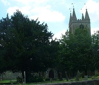
The Church of St Andrew in Chew Magna, Somerset, England dates from the 12th century with a large 15th-century pinnacled sandstone tower, a Norman font and a rood screen that is the full width of the church. It is a Grade I listed building.

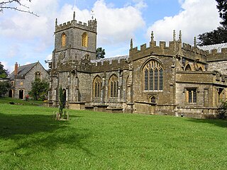
The Church of St James is a redundant church in Cameley, Somerset, England, dating from the late 12th century. It is recorded in the National Heritage List for England as a designated Grade I listed building, and is in the care of the Churches Conservation Trust. It is dedicated to St. James of Compostela. The church was declared redundant on 1 January 1980, and was vested in the Trust on 18 March 1981.

The Anglican Church of St Lawrence in Stanton Prior, Somerset, England, has its origins in the 12th century but is mainly 15th century. The church has been designated by English Heritage as a Grade II* listed building.
The Church of All Saints is an Anglican parish church in Farmborough, Somerset, England. It was principally built in the 15th century and has been designated as a Grade II* listed building.

The Church of St Leonard is a redundant church in Chelwood, Somerset, England. It was built in the 14th century and has been designated as a Grade II* listed building.

All Saints Church in Castle Cary in the English county of Somerset dates from 1470 and is notable for its high steeple. It is a Grade II* listed building.

