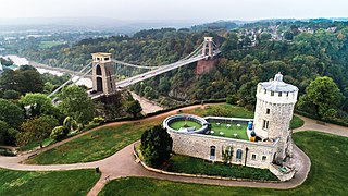
Bristol is a city, ceremonial county and unitary authority in England. On the River Avon, it is bordered by the ceremonial counties of Gloucestershire to the north and Somerset to the south. It is in the West of England Combined Authority and the most populous city in South West England. The wider Bristol Built-up Area is the eleventh most populous urban area in the United Kingdom.

The Stanton Drew stone circles are just outside the village of Stanton Drew in the English county of Somerset. The largest stone circle is the Great Circle, 113 metres (371 ft) in diameter and the second largest stone circle in Britain ; it is considered to be one of the largest Neolithic monuments to have been built. The date of construction is not known, but is thought to be between 3000 and 2000 BCE, which places it in the Late Neolithic to Early Bronze Age. It was made a scheduled monument in 1982.

Woodspring Priory is a former Augustinian priory. It is near the scenic limestone promontory of Sand Point and Middle Hope, owned by the National Trust, beside the Severn Estuary about 3 miles (5 km) north-east of Weston-super-Mare, within the English unitary authority of North Somerset. Many of the buildings are Grade I listed, and the whole site is scheduled as an ancient monument.
Brockley is a village and civil parish in Somerset, England. The parish is within the unitary authority of North Somerset, about 3 miles (4.8 km) south of Nailsea, and includes the village of Chelvey. According to the 2011 census it had a population of 277.
Clutton is a village and civil parish on the eastern edge of the affluent Chew Valley, close to the Cam Brook river, in the Bath and North East Somerset Council area, within the ceremonial county of Somerset, England. The village lies east of the A37 road between Bath and Shepton Mallet, and is 9 miles (14 km) from Bristol and Bath, and 11 miles (18 km) from Wells. Close by are the villages of Temple Cloud and High Littleton. The town of Midsomer Norton is 5 miles (8 km) away. The parish, which includes the hamlets of Clutton Hill and Northend, had a population of 1,602 in 2011.
The Chew Valley is an affluent area in North Somerset, England, named after the River Chew, which rises at Chewton Mendip, and joins the River Avon at Keynsham. Technically, the area of the valley is bounded by the water catchment area of the Chew and its tributaries; however, the name Chew Valley is often used less formally to cover other nearby areas, for example, Blagdon Lake and its environs, which by a stricter definition are part of the Yeo Valley. The valley is an area of rich arable and dairy farmland, interspersed with a number of villages.

Chelwood is a small village and civil parish in Somerset, England, and is in the affluent Chew Valley in the Bath and North East Somerset council area, about 8 miles (13 km) from Bristol and Bath. The parish, which includes the hamlets of West Chelwood and Breach, has a population of 148. It is situated on the A368 between Marksbury and Bishop Sutton, very close to the A37.
Marksbury is a small village and civil parish on the eastern edge of the affluent Chew Valley in Somerset, about 4 miles (6.4 km) from Keynsham and 7 miles (11.3 km) from Bath on the A39 where it meets the A368. The parish, which includes the villages of Hunstrete and Stanton Prior, has a population of 397.

Stanton Harcourt is a village and civil parish in Oxfordshire about 4 miles (6.4 km) southeast of Witney and about 6 miles (10 km) west of Oxford. The parish includes the hamlet of Sutton, 1⁄2 mile (800 m) north of the village. The 2011 Census recorded the parish's population as 960.

Holy Trinity Church is a Church of England parish church in Westbury-on-Trym, Bristol, England.

St Mary the Virgin is a Church of England parish church in Henbury, Bristol, England.

Stanton Prior is a small village within the civil parish of Marksbury, in the Bath and North East Somerset district, in the ceremonial county of Somerset, England. It is set in Duchy of Cornwall countryside between Newton St Loe and Marksbury, 6 miles (9.7 km) west from the UK city of Bath. In 1931 the parish had a population of 85. On 1 April 1933 the parish was abolished and merged with Marksbury.

The Brocket Arms is a country inn in Ayot St. Lawrence, Hertfordshire, England. According to Historic England, the timber-framed building is probably early sixteenth century, although an earlier date has been claimed.
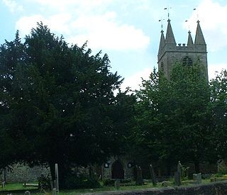
The Church of St Peter in Marksbury, Somerset, England dates from the 12th century, although most of the current fabric is from the 15th century and is a Grade II* listed building.

The Anglican Church of St Mary the Virgin in Stanton Drew, Somerset, England, was built in the 13th century. It is a Grade II* listed building.

St Laurence's Church is in Church Street, Church Stretton, Shropshire, England. It is an active Anglican parish church in the deanery of Condover, the archdeaconry of Ludlow, and the diocese of Hereford. Its benefice is united with those of St Michael and All Angels, All Stretton, and All Saints, Little Stretton to form the parish of Church Stretton. The church is recorded in the National Heritage List for England as a designated Grade I listed building.

Bath and North East Somerset is a unitary authority created on 1 April 1996, following the abolition of the County of Avon, which had existed since 1974. Part of the ceremonial county of Somerset, Bath and North East Somerset occupies an area of 220 square miles (570 km2), two-thirds of which is green belt. It stretches from the outskirts of Bristol, south into the Mendip Hills and east to the southern Cotswold Hills and Wiltshire border. The city of Bath is the principal settlement in the district, but BANES also covers Keynsham, Midsomer Norton, Radstock and the Chew Valley. The area has a population of 170,000, about half of whom live in Bath, making it 12 times more densely populated than the rest of the area.

The Anglican Church of St Lawrence, Wick St. Lawrence in the English county of Somerset dates mainly from the 15th century. It has been designated as a Grade II* listed building.


