
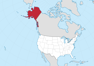
Alaska is a non-contiguous U.S. state on the northwest extremity of North America. Part of the Western United States region, it is one of the two non-contiguous U.S. states, alongside Hawaii. Alaska is also considered to be the northernmost, westernmost, and easternmost state in the United States. It borders the Canadian territory of Yukon and the province of British Columbia to the east. It shares a western maritime border, in the Bering Strait, with Russia's Chukotka Autonomous Okrug. The Chukchi and Beaufort Seas of the Arctic Ocean lie to the north, and the Pacific Ocean lies to the south. Technically, it is a semi-exclave of the U.S., and is the largest exclave in the world.
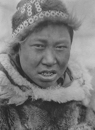
The Yupik are a group of Indigenous or Aboriginal peoples of western, southwestern, and southcentral Alaska and the Russian Far East. They are related to the Inuit and Iñupiat. Yupik peoples include the following:

Fairbanks is a home rule city and the borough seat of the Fairbanks North Star Borough, Alaska, United States. Fairbanks is the largest city in the interior region of Alaska and the second largest in the state. The 2020 census put the population of the city proper at 32,515 and the population of the Fairbanks North Star Borough at 95,655, making it the second most populous metropolitan area in Alaska after Anchorage. The Metropolitan Statistical Area encompasses all of the Fairbanks North Star Borough and is the northernmost metropolitan statistical area in the United States, located 196 miles by road south of the Arctic Circle.

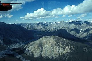
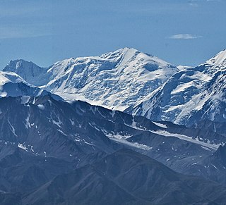
The Alaska Range is a relatively narrow, 600-mile-long (950 km) mountain range in the southcentral region of the U.S. state of Alaska, from Lake Clark at its southwest end to the White River in Canada's Yukon Territory in the southeast. Denali, the highest mountain in North America, is in the Alaska Range. The range is part of the American Cordillera.

The Department of Alaska was the designation for the government of Alaska from its purchase by the United States of America in 1867 until its organization as the District of Alaska in 1884. During the department era, Alaska was variously under the jurisdiction of the U.S. Army, the U.S. Dept. of the Treasury, and the U.S. Navy. The area later became the District of Alaska, then the Territory of Alaska, then the State of Alaska.

The Selawik River is a stream, 140 miles (230 km) long, in the northwestern part of the U.S. state of Alaska. Originating in the Purcell Mountains near the Zane Hills, it flows generally west through the Selawik National Wildlife Refuge to Selawik Lake, which empties into the Kotzebue Sound in the Chukchi Sea. The river is approximately at the latitude of the Arctic Circle.
The Ivishak River is a 95-mile (153 km) tributary of the Sagavanirktok River in the North Slope Borough of the U.S. state of Alaska. Fed by glaciers at the headwaters, the Ivishak flows northeast, then northwest, through the Philip Smith Mountains and the northern foothills of the Arctic National Wildlife Refuge. It enters the Sagavanirktok River on the coastal plain south of Prudhoe Bay.
The Wind River is a tributary of the East Fork Chandalar River in the U.S. state of Alaska. It arises in the Philip Smith Mountains of the Brooks Range and flows into the East Fork and eventually into the Yukon River.

Kiskatinaw Provincial Park is a provincial park located in Peace River Regional District in British Columbia, Canada. It was established on May 1, 1962 to protect a prominent horseshoe-shaped incised meander in the Kiskatinaw River where a historic curved bridge crosses the river along the original alignment of the Alaska Highway.
Mount Natazhat is a high peak of the Saint Elias Mountains, of Alaska, United States, just west of the border with the Yukon Territory of Canada. It lies on the northern edge of the range, south of the White River and north of the Klutlan Glacier. Mount Natazhat is a little-noticed peak; however it is a very large peak in terms of rise above local terrain. It rises 9,000 feet (2,743 m) in less than 7 miles (11.3 km) above the lowlands to the north, and 7,500 feet (2,286 m) in about 4 miles (6.4 km) above the Klutlan Glacier to the south.
Endicott River Wilderness is a 98,729-acre (39,954 ha) wilderness area in the U.S. state of Alaska. Designated by the United States Congress in 1980 in a provision of the Alaska National Interest Lands Conservation Act, it is located within the Tongass National Forest and is bordered by Glacier Bay Wilderness within Glacier Bay National Park on the west.

The Stikine Icecap is a large icefield straddled on the Alaska–British Columbia boundary in the Alaska Panhandle region. It lies in the Boundary Ranges of the Coast Mountains. Within the United States, most of it is under the administration of the Tongass National Forest and is part of the Stikine-LeConte Wilderness within the national forest.
Five Mile Airport is a private-use airport located in Five Mile in the U.S. state of Alaska. The airport is owned by the United States Bureau of Land Management (BLM) - Pipeline Office and managed by the Alyeska Pipeline Company. It is also known as Five Mile Camp Airport.
Mount Silverthrone is 13,220 ft (4,030 m) glaciated mountain summit located in Denali National Park and Preserve, in the Alaska Range, in the U.S. state of Alaska. It is situated 10.8 mi (17 km) east of Denali. The first ascent of this peak was made April 12, 1945, by Norman Bright and Frank P. Foster. It was so named by the U.S. Army Forces Cold Weather test party because of its stately appearance at the head of Brooks Glacier.
The following is an alphabetical list of articles related to Alaska.

The North Fork of the Koyukuk River is one of the principal forks of the Koyukuk River, approximately 105 mi (160 km) long, in northern Alaska in the United States. It has a watershed area of 1,850 square miles (4,800 km2). It rises on the south slopes of the Continental Divide in the Brooks Range.

Kates Needle is a mountain in the Stikine Icecap region of the Alaska-British Columbia border west of the junction of the Stikine River and Porcupine River. The summit has also been known as Boundary Peak 70.
The Yukon Flats National Wildlife Refuge is a protected wetland area in the U.S. state of Alaska. It encompasses most of the Yukon Flats, a vast wetland area centered on the confluence of the Yukon River, Porcupine River, and Chandalar River.
