
Alanya, formerly Alaiye, is a beach resort city, a municipality and district of Antalya Province, Turkey. It is on the southern coast of Turkey, in the country's Mediterranean Region, 133 kilometres (83 mi) east of the city of Antalya. Its area is 1,577 km2, and its population is 364,180 (2022). The city proper has 189,222 inhabitants (2022).

Gazipaşa is a municipality and district of Antalya Province, Turkey. Its area is 1,111 km2, and its population is 53,702 (2022). It is situated on the Mediterranean coast, 180 km east of the city of Antalya. Gazipaşa is a quiet rural district famous for its bananas and oranges. Gazipaşa district is adjacent to Alanya to the northwest, Sarıveliler to the north, Anamur to the east, and the Mediterranean Sea to the west.

Mahmutlar is a neighbourhood of the municipality and district of Alanya, Antalya Province, Turkey. Its population is 53,034 (2022). It lies 10 km east of Alanya. Before the 2013 reorganisation, it was a town (belde). The town has been transformed by the building of holiday homes and apartments for European tourists. Roads and services have been improved to cater for the growing tourist industry.
Yeşilöz is a neighbourhood in the municipality and district of Alanya, Antalya Province, Turkey. Its population is 1,270 (2022). It is a beach resort village on the south Mediterranean coast. Yeşilöz has a large sandy beach that stretches for about 3 km. There are several small shops, a variety of restaurants, a barber, 2 hotels and some of Turkey's most exclusive private villas.
Oba is a neighbourhood in the municipality and district of Alanya, Antalya Province, Turkey. Its population is 28,864 (2022). Before the 2013 reorganisation, it was a town (belde). It is almost merged to Alanya. It is about 140 kilometres (87 mi) from Antalya.
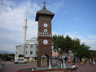
Konaklı is a neighbourhood in the municipality and district of Alanya, Antalya Province, Turkey. Its population is 17,966 (2022). Before the 2013 reorganisation, it was a town (belde).

Avsallar is a neighbourhood in the municipality and district of Alanya, Antalya Province, Turkey. Its population is 15,220 (2022). Before the 2013 reorganisation, it was a town (belde).
Burçaklar is a neighbourhood in the municipality and district of Alanya, Antalya Province, Turkey. Its population is 301 (2022). It is located between Alanya and Gündoğmuş. In 2001 it passed from the Gündoğmuş District to the Alanya District.
Demirtaş is a neighbourhood in the municipality and district of Alanya, Antalya Province, Turkey. Its population is 3,449 (2022). Before the 2013 reorganisation, it was a town (belde).
Emişbeleni is a neighbourhood in the municipality and district of Alanya, Antalya Province, Turkey. Its population is 1,492 (2022). Before the 2013 reorganisation, it was a town (belde).

Güzelbağ is a neighbourhood in the municipality and district of Alanya, Antalya Province, Turkey. Its population is 762 (2022). Before the 2013 reorganisation, it was a town (belde).
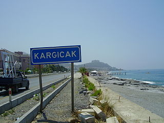
Kargıcak is a neighbourhood in the municipality and district of Alanya, Antalya Province, Turkey. Its population is 5,989 (2022). Before the 2013 reorganisation, it was a town (belde).
Kestel is a neighbourhood in the municipality and district of Alanya, Antalya Province, Turkey. Its population is 15,445 (2022). Before the 2013 reorganisation, it was a town (belde).
Payallar is a neighbourhood in the municipality and district of Alanya, Antalya Province, Turkey. Its population is 9,691 (2022). This place is located on the southern coast of Turkey. Before the 2013 reorganisation, it was a town (belde).
Tosmur is a neighbourhood in the municipality and district of Alanya, Antalya Province, Turkey. Its population is 11,712 (2022). Before the 2013 reorganisation, it was a town (belde).
Türkler is a neighbourhood in the municipality and district of Alanya, Antalya Province, Turkey. Its population is 4,798 (2022). Before the 2013 reorganisation, it was a town (belde).
Çıplaklı is a neighbourhood in the municipality and district of Alanya, Antalya Province, Turkey. Its population is 9,139 (2022). Before the 2013 reorganisation, it was a town (belde).
İncekum is a neighbourhood in the municipality and district of Alanya, Antalya Province, Turkey. Its population is 3,345 (2022). Before the 2013 reorganisation, it was a town (belde).
Şıhlar is a neighbourhood in the municipality and district of Alanya, Antalya Province, Turkey. Its population is 622 (2022).
Orhanköy is a neighbourhood in the municipality and district of Alanya, Antalya Province, Turkey. Its population is 188 (2022). In 2001 it passed from the Gündoğmuş District to the Alanya District.
