
Randwick is a suburb in the Eastern Suburbs of Sydney, in the state of New South Wales, Australia. Randwick is located 6 kilometres south-east of the Sydney central business district and is the administrative centre for the local government area of the City of Randwick. Randwick is part of the Eastern Suburbs region. The postcode is 2031.

The Bank of New South Wales (BNSW), also known commonly as The Wales, was the first bank in Australia, being established in Sydney in 1817 and situated on Broadway. During the 19th century, the bank opened branches throughout Australia and New Zealand, expanding into Oceania in the 20th century. It merged with many other financial institutions, finally merging with the Commercial Bank of Australia in 1982 and being renamed to the Westpac Banking Corporation on 4 May that year under the Bank of New South Wales Act 1982.

Pitt Street is a major street in the Sydney central business district in New South Wales, Australia. The street runs through the entire city centre from Circular Quay in the north to Waterloo, although today's street is in two disjointed sections after a substantial stretch of it was removed to make way for Sydney's Central railway station. Pitt Street is well known for the pedestrian only retail centre of Pitt Street Mall, a section of the street which runs from King Street to Market Street.

The City of Willoughby is a local government area on the Lower North Shore of Northern Sydney, in the state of New South Wales, Australia. It is located 6 kilometres (3.7 mi) north of the Sydney central business district. It was first proclaimed in October 1865 as the Municipality of North Willoughby.
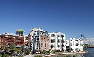
Pyrmont is an inner-city suburb of Sydney, in the state of New South Wales, Australia 2 kilometres south-west of the Sydney central business district in the local government area of the City of Sydney. It is also part of the Darling Harbour region. As of 2011, it is Australia's most densely populated suburb.
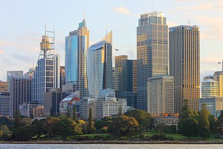
The Sydney Central Business District (CBD) is the historical and main commercial centre of Sydney. The Sydney CBD is Sydney's city centre, or Sydney City, and the two terms are used interchangeably. The CBD or city centre is often referred to simply as "Town" or "the City". The Sydney city centre extends southwards for about 3 km (2 mi) from Sydney Cove, the point of first European settlement in which the Sydney region was initially established. Due to its pivotal role in Australia's early history, it is one of the oldest established areas in the country.

The City of Campbelltown is a local government area in the Macarthur region of south-western Sydney, in New South Wales, Australia. The area is located about 55 kilometres (34 mi) south west of the Sydney central business district and comprises 312 square kilometres (120 sq mi).

North Sydney Council is a local government area on the Lower North Shore of Sydney, New South Wales, Australia, established on 29 July 1890 through the amalgamation of three boroughs.

The City of Penrith is a local government area in the state of New South Wales, Australia. The seat of the city is located in Penrith, located about 50 kilometres (31 mi) west of Sydney's central business district. It occupies part of the traditional lands of the Darug people. First incorporated as a municipality on 12 May 1871, on 1 January 1949, the municipalities of Penrith, St Marys and Castlereagh and part of the Nepean Shire amalgamated to form a new Municipality of Penrith. Penrith was declared a City on 21 October 1959, and expanded westwards to include Emu Plains and Emu Heights, formerly part of the City of Blue Mountains, on 25 October 1963. As at the 2016 census the City of Penrith had an estimated population of 196,066

The City of Randwick is a local government area in the eastern suburbs of Sydney, New South Wales, Australia. Established in 1859, Randwick is the second-oldest local government area in New South Wales, after the City of Sydney. It comprises an area of 36 square kilometres (14 sq mi) and as at the 2016 census had a population of 140,660.
The City of Orange is a local government area in the central west region of New South Wales, Australia. Based in Orange, the area is located adjacent to the Mitchell Highway and the Main Western railway line.
Australian non-residential architectural styles are a set of Australian architectural styles that apply to buildings used for purposes other than residence and have been around only since the first colonial government buildings of early European settlement of Australia in 1788.

Hong Kong House, also known since 1995 as the Hong Kong Economic and Trade Office, Sydney, is a landmark heritage building and former hotel in the Sydney central business district, City of Sydney, New South Wales, Australia. Built in 1891 to a design by Ambrose Thornley, it is located on 80 Druitt Street, at the corner with York Street, and is adjacent to other prominent heritage landmarks, the Sydney Town Hall and the Queen Victoria Building. Formerly known as Gresham Hotel, the property was added to the New South Wales State Heritage Register on 2 April 1999.

Bridge Street is a street in the central business district of Sydney in New South Wales, Australia. Bridge Street runs for 500 metres (1,600 ft) in a west–east direction with traffic flowing in both directions. It is situated in the northern portion of the central business district. The western terminus of Bridge Street is at George Street, with the eastern terminus at Macquarie Street, adjacent to the Chief Secretary's Building. From west to east, Bridge Street crosses Pitt and Phillip streets.

Sussex Street is a street in the central business district of Sydney in New South Wales, Australia. It runs north-south along the western side of the city, between Hickson Road and Hay Street. It is in the local government area of the City of Sydney. The street is 1.7 kilometres (1.1 mi) long. It was named in honour of Prince Augustus Frederick, Duke of Sussex, the sixth son of King George III.

The Colonial Mutual Life Building is a heritage-listed insurance office at Clifford Street, Goulburn, Goulburn Mulwaree Council, New South Wales, Australia. It is also known as the CML Building. It was added to the New South Wales State Heritage Register on 2 April 1999.

The Skinners Family Hotel is a heritage-listed former pub and now retail optometrist shop, located at 296 George Street, in the Sydney central business district, in the City of Sydney local government area of New South Wales, Australia. It was added to the New South Wales State Heritage Register on 2 April 1999.

Kings Hotel is a heritage-listed former pub and now commercial premises located at 138-140 Pitt Street, in the Sydney central business district, in the City of Sydney local government area of New South Wales, Australia. It was built from 1879. It is also known as Trickett's Hotel and Sugar House. It was added to the New South Wales State Heritage Register on 2 April 1999.

National House is a heritage-listed former warehouse and bank branch and now pub located at 75 York Street, on the corner of King Street, in the Sydney central business district, in the City of Sydney local government area of New South Wales, Australia. It now operates as the Hotel CBD. It was added to the New South Wales State Heritage Register on 2 April 1999.

Erskine Street Police Station is a heritage-listed former police station at 82 Erskine Street, Sydney, City of Sydney, New South Wales, Australia. It was designed by William Dumaresq and built in 1827. It is also known as the Erskine Street Watch House. It was added to the New South Wales State Heritage Register on 2 April 1999.

