San Luis Obispo Historic Resources
| # [6] | Name | Image | Location | Historic District | Built [7] | Description |
|---|---|---|---|---|---|---|
| 1 | Andrews Adobe (aka El Rancho Alisal, Wolfe Residence, Wilkinson Adobe) | 1451 Andrews 35°17′09″N120°38′48″W / 35.285955°N 120.646584°W | 1790s | Two-story clapboard covered adobe; originally a one-story house built prior to 1800 under supervision of the Mission padres and believed to be the residence of the Mission orchards' mayordomo; believed to be the second oldest surviving structure in the county; acquired by J.P. Andrews c. 1870; second story added 1906 [8] | ||
| 2 | Manderscheid House | 963 Broad 35°16′50″N120°39′54″W / 35.280583°N 120.665125°W | Downtown HD | 1891 | Owned in early 1900s by Pacific Coast Railway conductor Richard Manderscheid | |
| 3 | Dutton House | 1426 Broad 35°16′34″N120°39′43″W / 35.276135°N 120.662028°W | Old Town HD | 1904-08 | ||
| 4 | Miller House | 1435 Broad 35°16′34″N120°39′43″W / 35.276039°N 120.661937°W | Old Town HD | 1897 | ||
| 5 | Vetterline House | 1504 Broad 35°16′32″N120°39′42″W / 35.275693°N 120.66162°W | Old Town HD | 1895-1900 | ||
| 6 | Maier House | 1411 Broad 35°16′35″N120°39′44″W / 35.276413°N 120.662291°W | Old Town HD | 1933 | ||
| 7 | Falkenstein House | 1445 Broad 35°16′33″N120°39′43″W / 35.275925°N 120.66183°W | Old Town HD | 1895 | ||
| 8 | McKennon House | 1510 Broad 35°16′32″N120°39′42″W / 35.275592°N 120.661531°W | Old Town HD | 1890 | ||
| 9 | Renetzky House | 1516 Broad 35°16′32″N120°39′41″W / 35.275459°N 120.661412°W | Old Town HD | 1904 | ||
| 10 | Tucker House | 1530 Broad 35°16′31″N120°39′41″W / 35.275375°N 120.661338°W | Old Town HD | 1905 | ||
| 11 | Brazil House | 148 Broad 35°17′24″N120°40′18″W / 35.289963°N 120.671716°W | 1931-33 | |||
| 12 | Bradbury House | 745 Buchon 35°16′35″N120°39′40″W / 35.276272°N 120.661125°W | Old Town HD | 1910 | One-story "Neo-Classic rowhouse" built for Dr. Richard Bradbury who built the Bradbury Sanitarium next door one year later [9] | |
| 13 | Stanton House (aka Silvaggio Home, Lewin Home) | 752 Buchon 35°16′35″N120°39′40″W / 35.276334°N 120.661023°W | Old Town HD | 1903-05 | 17-room Victorian Shingle Cottage in Queen Anne style with Neo-Classic elements; built for Edward Stanton, an officer of the Pacific Coast Railroad, and his wife Irene, a daughter of Charles William Dana. [10] | |
| 14 | Manuel Marshall House (aka Dixon Home) | 785 Buchon 35°16′36″N120°39′38″W / 35.276681°N 120.660434°W | Old Town HD | 1899 | Neo-Classic House with elements of a Queen Anne cottage; the original owner Manuel Marshall was a prominent jeweler [11] | |
| 15 | Fred Crossett House (aka Boatman House) | 896 Buchon 35°16′39″N120°39′33″W / 35.277434°N 120.659106°W | Old Town HD | 1914-18 | Two-story Craftsman bungalow [12] | |
| 16 | Myron Angel House |  | 714 Buchon 35°16′33″N120°39′39″W / 35.275833°N 120.660833°W | Old Town HD | c. 1880 | Two-story wood-frame hous was the home from 1889-1911 of Myron Angel, the main force behind the founding of California Polytechnic State University; listed on the National Register of Historic Places (NRHP) in 1982 [13] |
| 17 | Jessie Wright Maternity Home (aka Estrada House) | 726 Buchon 35°16′34″N120°39′41″W / 35.276129°N 120.66136°W | Old Town HD | 1900 | Wood frame home in Carpenter Gothic Revival style with Queen Anne elements and a Neo-Colonial porch; operated as a maternity home in the 1920s [14] | |
| 18 | Bradbury Sanitarium (also known as Pacific Hospital) | 743 Buchon 35°16′34″N120°39′41″W / 35.276188°N 120.661262°W | Old Town HD | 1911-12 | Built by Dr. Richard Bradbury as a sanitarium; Classical Revival style later vernacularized as "American Four Square"; later used for military housing in World War II; became an apartment building after the war [15] | |
| 19 | Ed Kaiser House (aka Carpenter House) | 751 Buchon 35°16′35″N120°39′40″W / 35.276352°N 120.660994°W | Old Town HD | 1904-08 | Two-story Colonial Revival, American Four Square house with Doric columns; was the home of cigar dealer and bar owner, Ed Kaiser [16] | |
| 20 | Nathaniel Brew House | 771 Buchon 35°16′35″N120°39′38″W / 35.276329°N 120.660551°W | Old Town HD | 1903 | Home with eclectic design including Carpenter Gothic and Neo-Colonial styles; owned by Nathaniel Brew who operated a furniture and carpet business [17] | |
| 21 | Upham House (aka Trousdale Home, Soderberg Home) | 779 Buchon 35°16′36″N120°39′38″W / 35.276603°N 120.660569°W | Old Town HD | 1898 | Two-story home in Carpenter Gothic style with Neo-Classic elements [18] | |
| 22 | Jacob Crocker House (aka Gerety Residence) | 793 Buchon 35°16′36″N120°39′37″W / 35.276691°N 120.660232°W | Old Town HD | 1901-02 | Ornate two-story Queen Anne house with Colonial Revival influence built for Jacob Crocker, a prosperous businessman and merchant [19] | |
| 23 | A. F. Fitzgerald House (aka Kimball Home) | 794 Buchon 35°16′36″N120°39′37″W / 35.276791°N 120.660404°W | Old Town HD | 1902 | Two-story Italianate house built by Joseph Maino for A. F. Fitzgerald, a prominent businessman who was involved in the founding of Cal Poly [20] | |
| 24 | Clark/Norton House (aka Greystone House) | 850 Buchon 35°16′37″N120°39′36″W / 35.276996°N 120.659885°W | Old Town HD | 1904-08 | Two-story vernacular Neo-Colonial house with pronounced horizontal orientation; served as the residence of two SLO mayors over the years, Elmer Clark and Thomas Norton; when built by Clark it was the largest home in SLO at 4,500 square feet [21] | |
| 25 | Hourihan House (aka Campbell House) | 860 Buchon 35°16′38″N120°39′34″W / 35.277174°N 120.659568°W | Old Town HD | 1895 | Two-story Carpenter Gothic Revival house, built for Thomas and Kate Hourihan, ranchers from Arroyo Grande [22] | |
| 26 | Pete Paulson House (aka Fred Cossett House) | 890 Buchon 35°16′38″N120°39′33″W / 35.27736°N 120.659238°W | Old Town HD | 1919 | Classic Revival house in Craftsman style with Prairie School elements; built for Pete Paulson, a salesman for the Channel Commercial Company [23] | |
| 27 | Fleuger House | 1546 Chorro 35°16′34″N120°39′34″W / 35.276139°N 120.659529°W | Old Town HD | 1903 | ||
| 28 | Aston House | 1746 Chorro 35°16′29″N120°39′30″W / 35.27465°N 120.658202°W | 1903 | |||
| 29 | Wade Building | 1026 Chorro 35°16′49″N120°39′48″W / 35.280258°N 120.663202°W | Downtown HD | 1909 | ||
| 30 | Dughi Building | 1029 Chorro 35°16′49″N120°39′47″W / 35.280171°N 120.663127°W | Downtown HD | 1885 | ||
| 31 | Wickenden Building | 1033 Chorro 35°16′49″N120°39′47″W / 35.280175°N 120.66313°W | Downtown HD | 1885 | ||
| 32 | Sauer/Adams Adobe | 964 Chorro 35°16′52″N120°39′50″W / 35.281066°N 120.663918°W | Chinatown HD | 1800/1860 | Original adobe built c. 1800; second story added 1860 | |
| 33 | Brooks House | 1518 Chorro 35°16′35″N120°39′35″W / 35.276399°N 120.659767°W | Old Town HD | 1890 | ||
| 34 | Regan House | 1306 Chorro 35°16′42″N120°39′41″W / 35.278208°N 120.661379°W | 1883 | |||
| 35 | Mazza House | 1318 Chorro 35°16′41″N120°39′40″W / 35.278037°N 120.661238°W | 1906 | |||
| 36 | Finney House | 1907 Chorro 35°16′24″N120°39′26″W / 35.273371°N 120.657321°W | 1890 | |||
| 37 | Mancilla/Freitas Adobe | 868 Chorro 35°16′55″N120°39′53″W / 35.281836°N 120.664609°W | 1850 | |||
| 38 | Rosa Butron Adobe | 466 Dana 35°16′40″N120°40′08″W / 35.277811°N 120.668832°W | Downtown HD | 1860 | ||
| 39 | Anderson House | 532 Dana 35°16′42″N120°40′04″W / 35.278461°N 120.667816°W | Downtown HD | 1898 | ||
| 40 | Barneberg House | 550 Dana 35°16′43″N120°40′03″W / 35.278621°N 120.667541°W | Downtown HD | 1914 | Two-story Neo-Classical style house with Craftsman and Prairie School overtones; built by James Maino for J. W. Barneberg, president of the Commercial Bank and one of the City's first millionaires; later known as Duenow Residence [24] | |
| 41 | Frank Anderson House | 1345 Broad 35°16′36″N120°39′45″W / 35.276683°N 120.662545°W | Old Town HD | 1910-14 | One-story Neo-Classical rowhouse/Victorial cottage built for Frank Anderson, a lineman for Pacific Telephone and Telegraph Co. [25] | |
| 42 | Goldtree/McCafrey House | 1212 Garden 35°16′42″N120°39′45″W / 35.278369°N 120.662563°W | 1898 | |||
| 43 | Union Hardware Building | 1119 Garden 35°16′45″N120°39′48″W / 35.279076°N 120.663213°W | Downtown HD | 1912 | ||
| 44 | Smith Building | 1123 Garden 35°16′44″N120°39′47″W / 35.278984°N 120.663131°W | Downtown HD | 1924-25 | ||
| 45 | Laird Building | 1129 Garden 35°16′44″N120°39′47″W / 35.27884°N 120.663004°W | Downtown HD | 1883 | ||
| 46 | Stover Building | 1130 Garden 35°16′44″N120°39′47″W / 35.278861°N 120.663022°W | Downtown HD | 1913 | ||
| 47 | Weill House | 2132 Harris 35°16′14″N120°39′49″W / 35.270496°N 120.663513°W | 1889 | |||
| 48 | Golden State Creamery | 570 Higuera 35°16′40″N120°39′59″W / 35.277763°N 120.666483°W | Downtown HD | 1910 | ||
| 49 | Greenfield Building | 719 Higuera 35°16′44″N120°39′52″W / 35.278924°N 120.664363°W | Downtown HD | 1905 | ||
| 50 | Kluver Cigar | 726 Higuera 35°16′45″N120°39′51″W / 35.279123°N 120.664168°W | Downtown HD | 1897 | Home of the Kluver & Sons Pioneer Cigar factory operated by George Kluver | |
| 51 | Carrisa Building | 736 Higuera 35°16′45″N120°39′50″W / 35.279229°N 120.663984°W | Downtown HD | 1906 | ||
| 52 | Vollmer Grocery | 740 Higuera 35°16′45″N120°39′50″W / 35.279288°N 120.66388°W | Downtown HD | 1890 | ||
| 53 | Bank of America Building | 767 Higuera 35°16′46″N120°39′48″W / 35.279552°N 120.66342°W | Downtown HD | 1901-02 | ||
| 54 | Doton Building | 777 Higuera 35°16′47″N120°39′48″W / 35.279629°N 120.663287°W | Downtown HD | 1931 | ||
| 55 | Johnson Building | 796 Higuera 35°16′47″N120°39′46″W / 35.279848°N 120.662902°W | Downtown HD | 1903-04 | ||
| 56 | Commercial Bank Building | 799 Higuera 35°16′48″N120°39′46″W / 35.27999°N 120.662666°W | Downtown HD | 1891 | ||
| 57 | Tower Building/H. M. Warden Building | 842 Higuera 35°16′47″N120°39′47″W / 35.279798°N 120.662989°W | Downtown HD | 1904 | Two-story commercial building; built as an office building by Horatio M. Warden; ornate clock tower removed after 1925 Santa Barbara earthquake; became Tower Building prior to World War II; first floor extensively altered [26] | |
| 58 | Goldtree Block/Hotel Wineman |  | 849 Higuera 35°16′49″N120°39′44″W / 35.280212°N 120.662303°W | Downtown HD | 1883/1930 | Large commercial building originally operated as a general merchandise store the Goldtree Brothers; the Wineman Hotel opened at the location in 1931; ground floor was Riley's Department Store from 1955 to 1993 [27] |
| 59 | A. F. Fitzgerald Building | 852 Higuera 35°16′48″N120°39′45″W / 35.280034°N 120.662592°W | Downtown HD | 1903 | ||
| 60 | Sandercock Transfer Building | 856 Higuera 35°16′48″N120°39′45″W / 35.280058°N 120.662553°W | Downtown HD | 1890 | Home of Sandercock Transfer Co., a drayage company that delivered freight for the Pacific Coast Railway | |
| 61 | H. H. Waite Planing Mill | 236 Higuera 35°16′15″N120°40′13″W / 35.270834°N 120.670142°W | 1883 | |||
| 62 | Loomis Feed Co. Warehouse |  | 75 Higuera 35°16′22″N120°39′54″W / 35.272778°N 120.665°W | 1885 | Wood frame building with corrugated iron paneling; only surviving building from the Pacific Coast Railway's headquarters as well as the only extant grain storage building in San Luis Obispo; listed on the NRHP in 1988 | |
| 63 | Sandercock House | 591 Islay 35°16′27″N120°39′45″W / 35.274199°N 120.66252°W | Old Town HD | 1910 | ||
| 64 | Fitzpatrick House | 670 Islay 35°16′29″N120°39′42″W / 35.274746°N 120.661616°W | Old Town HD | 1880 | ||
| 65 | Erickson House | 461 Islay 35°16′23″N120°39′52″W / 35.27305°N 120.664393°W | 1900 | |||
| 66 | Vollmer House | 497 Islay 35°16′24″N120°39′50″W / 35.27343°N 120.663792°W | 1890 | |||
| 67 | Vollmer House | 1116 Pismo 35°16′48″N120°39′25″W / 35.279966°N 120.656942°W | Old Town HD | 1912 | ||
| 68 | Sandercock House | 535 Islay 35°16′25″N120°39′48″W / 35.273661°N 120.663414°W | Old Town HD | 1910 | ||
| 69 | Dana/Parsons House | 644 Islay 35°16′28″N120°39′43″W / 35.274469°N 120.662072°W | Old Town HD | 1875 | ||
| 70 | Erickson House | 687 Islay 35°16′30″N120°39′41″W / 35.274913°N 120.66134°W | Old Town HD | 1894-95 | ||
| 71 | Kimball House | 690 Islay 35°16′30″N120°39′41″W / 35.274948°N 120.661283°W | Old Town HD | 1900 | ||
| 72 | Jackson House | 790 Islay 35°16′33″N120°39′35″W / 35.275932°N 120.659668°W | Old Town HD | 1910 | ||
| 73 | Fumigalli House | 463 Islay 35°16′23″N120°39′51″W / 35.273177°N 120.664192°W | 1900 | |||
| 74 | The Judge's House | 1720 Johnson 35°16′47″N120°39′04″W / 35.279701°N 120.651148°W | 1892-1906 | |||
| 75 | Buckley House | 777 Johnson 35°17′11″N120°39′32″W / 35.286261°N 120.658962°W | Mill Street HD | 1890 | ||
| 76 | Post House | 1019 Leff 35°16′36″N120°39′23″W / 35.276779°N 120.656267°W | Old Town HD | 1900 | ||
| 77 | Madonna Inn |  | 100 Madonna 35°16′03″N120°40′29″W / 35.2675°N 120.67472°W | 1961-69 | Motel built by Alex Madonna along US Route 101; features a pseudo-Swiss-Alps exterior and lavish common rooms accented by pink roses, Western murals, and hammered copper; 110 uniquely designed and themed guest rooms and suites | |
| 78 | Esquar House | 1117 Marsh 35°16′53″N120°39′30″W / 35.281453°N 120.65838°W | 1888 | |||
| 79 | Stover's Sanitarium | 1160 Marsh 35°16′55″N120°39′27″W / 35.282004°N 120.657503°W | 1911 | |||
| 80 | Graves House | 1167 Marsh 35°16′55″N120°39′27″W / 35.281935°N 120.657613°W | 1929 | |||
| 81 | Kaetzel House | 547 Marsh 35°16′37″N120°39′57″W / 35.276888°N 120.66595°W | 1882 | |||
| 82 | Snyder Building | 774 Marsh 35°16′44″N120°39′46″W / 35.278805°N 120.662744°W | Downtown HD | 1925 | ||
| 83 | Ramage House | 1129 Marsh 35°16′53″N120°39′30″W / 35.281497°N 120.658311°W | 1905 | |||
| 84 | Shipman House | 1135 Marsh 35°16′54″N120°39′30″W / 35.281556°N 120.658217°W | 1888 | |||
| 85 | The Nurse's House | 1141 Marsh 35°16′54″N120°39′29″W / 35.28161°N 120.658131°W | 1890 | |||
| 86 | Faulkner House | 1145 Marsh 35°16′54″N120°39′29″W / 35.281654°N 120.65806°W | 1915 | |||
| 87 | Reid House | 1305 Marsh 35°16′59″N120°39′21″W / 35.283121°N 120.655765°W | 1930 | |||
| 88 | Robert Jack House |  | 536 Marsh 35°16′38″N120°39′53″W / 35.277222°N 120.664722°W | 1880 | Two-story Italianate-style house operated by the city as a museum and events center; listed on the NRHP in 1992 [28] | |
| 89 | Masonic Temple | 859 Marsh 35°16′46″N120°39′42″W / 35.279372°N 120.661773°W | 1913 | [29] | ||
| 90 | U.S. Post Office | 893 Marsh 35°16′47″N120°39′41″W / 35.279683°N 120.661278°W | 1925 | |||
| 91 | First Presbyterian Church | 951 Marsh 35°16′48″N120°39′38″W / 35.28007°N 120.660651°W | 1905 | English Arts and Crafts style church built using granite quarried from nearby Bishop Peak [30] | ||
| 92 | Frederick Hart Building | 981 Marsh 35°16′48″N120°39′38″W / 35.280108°N 120.660588°W | 1928 | |||
| 93 | William Shipsey House |  | 1266 Mill 35°17′09″N120°39′32″W / 35.285853°N 120.658906°W | Mill Street HD | 1890 | Home built with Queen Anne and Stick/Eastlake elements; listed on NRHP in 2010 [31] |
| 94 | Smith House | 1306 Mill 35°17′10″N120°39′31″W / 35.286055°N 120.658572°W | Mill Street HD | 1905 | ||
| 95 | Maino House | 1424 Mill 35°17′14″N120°39′24″W / 35.287129°N 120.656778°W | 1926 | |||
| 96 | Mugler House | 1460 Mill 35°17′14″N120°39′23″W / 35.287311°N 120.656459°W | 1925 | |||
| 97 | Muscio House | 1330 Mill 35°17′11″N120°39′29″W / 35.286348°N 120.658097°W | Mill Street HD | 1909 | ||
| 98 | Hays/Lattimer Adobe | 642 Monterey 35°16′46″N120°39′56″W / 35.279487°N 120.665685°W | Downtown HD | 1860 | ||
| 99 | Mission San Luis |  | 782 Monterey 35°16′49″N120°39′53″W / 35.28031°N 120.664666°W | Downtown HD | 1812 | Spanish mission founded in 1772 by Father Junípero Serra [32] |
| 100 | Fremont Theater |  | 1035 Monterey 35°16′56″N120°39′39″W / 35.282162°N 120.660767°W | Downtown HD | 1941 | Streamline Moderne theater designed by architect S. Charles Lee [33] |
| 101 | Dr. George Nichols House | 664 Monterey 35°16′47″N120°39′55″W / 35.279712°N 120.665295°W | Downtown HD | 1907 | One-story Colonial Revival house [34] | |
| 102 | San Luis Obispo Carnegie Library |  | 696 Monterey 35°16′49″N120°39′50″W / 35.280278°N 120.663889°W | Downtown HD | 1905 | Richardsonian Romanesque Carnegie library faced in red brick with yellow sandstone trim; listed on NRHP in 1995; operated as the county's historical museum since 1956 [35] |
| 103 | Murray Adobe | 747 Monterey 35°16′48″N120°39′54″W / 35.27991°N 120.664984°W | Downtown HD | 1850 | Two-room adobe; used by Walter Murray as a residence and later to house the printing press for his newspaper, the Tribune; later owned by the City and served as office for the Historical Resources survey in the early 1980s [36] | |
| 104 | Sauer Bakery | 848 Monterey 35°16′51″N120°39′47″W / 35.280705°N 120.663119°W | Downtown HD | 1875 | Two-story commercial structure; extensive alterations have covered its original character [37] | |
| 105 | Sinsheimer Building | 849 Monterey 35°16′50″N120°39′47″W / 35.280684°N 120.663155°W | Downtown HD | 1884 | First floor was a general store operated by Sinsheimer Brothers; second floor was used for offices; only known cast iron facade on the Central Coast [38] | |
| 106 | Muzio's Grocery | 868 Monterey 35°16′51″N120°39′46″W / 35.280875°N 120.662827°W | Downtown HD | 1912 | Grocery store operated by Italian immigrants; customers included William Randolph Hearst [39] | |
| 107 | Anderson Hotel | 955 Monterey 35°16′53″N120°39′44″W / 35.28129°N 120.662165°W | Downtown HD | 1922-23 | Elegant Mediterranean style five-story hotel designed for J.C. Anderson, was the tallest building in downtown [40] | |
| 108 | Brunner Building (aka Woodman of the World Hall) | 962 Monterey 35°16′53″N120°39′43″W / 35.28138°N 120.662021°W | Downtown HD | 1922-23 | Two-story Renaissance Revival building; originally operated with Moose lodge on second floor and retail on ground floor [41] | |
| 109 | J. P. Andrews Building | 998 Monterey 35°16′54″N120°39′42″W / 35.281691°N 120.661537°W | Downtown HD | 1893-1906 | Two-story commercial building, it originally housed Andrews Bank [42] | |
| 110 | Monday Club |  | 1815 Monterey 35°17′19″N120°39′05″W / 35.288551°N 120.651366°W | 1933 | Designed by Julia Morgan; listed on the NRHP [43] | |
| 111 | Milestone Motel Inn | 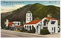 | 2223 Monterey 35°17′29″N120°38′52″W / 35.291513°N 120.647748°W | 1924-25 | Claimed as the first motel in the world, closed in 1991; now the administrative building of the Apple Farm hotel next door [44] | |
| 112 | Snyder House | 1406 Morro 35°16′41″N120°39′34″W / 35.278056°N 120.65944°W | Old Town HD | 1885 | ||
| 113 | Bullard House | 1624 Morro 35°16′35″N120°39′28″W / 35.276256°N 120.657828°W | Old Town HD | 1905 | ||
| 114 | Baker House | 1636 Morro 35°16′35″N120°39′29″W / 35.276494°N 120.658043°W | Old Town HD | 1900 | ||
| 115 | Albert House | 1642 Morro 35°16′35″N120°39′29″W / 35.276447°N 120.658°W | Old Town HD | 1900 | ||
| 116 | Rogers House | 1428 Nipomo 35°16′31″N120°39′48″W / 35.2754°N 120.663255°W | Old Town HD | 1890 | ||
| 117 | Harmony Creamery | 991 Nipomo 35°16′46″N120°40′01″W / 35.279535°N 120.666978°W | Downtown HD | 1929 | ||
| 118 | St. Stephen's Episcopal Church |  | 1344 Nipomo 35°16′35″N120°39′51″W / 35.276416°N 120.664043°W | Old Town HD | 1873 | |
| 119 | Patton House | 1407 Nipomo 35°16′33″N120°39′49″W / 35.275712°N 120.663544°W | Old Town HD | 1913 | ||
| 120 | Nichols House | 1446 Nipomo 35°16′31″N120°39′47″W / 35.275181°N 120.663053°W | Old Town HD | 1903 | ||
| 121 | Parsons House | 1204 Nipomo 35°16′42″N120°39′29″W / 35.278225°N 120.658161°W | 1919 | |||
| 122 | M. F. Avila House | 1443 Osos 35°16′42″N120°39′29″W / 35.278225°N 120.658161°W | Old Town HD | 1927-29 | ||
| 123 | Park/Reidy Hotel | 1815 Osos 35°16′32″N120°39′21″W / 35.275672°N 120.655847°W | Railroad HD | 1907 | ||
| 124 | Teass House | 890 Osos 35°16′58″N120°39′44″W / 35.282825°N 120.662242°W | Downtown HD | 1929 | ||
| 125 | County Courthouse | 976 Osos 35°16′56″N120°39′42″W / 35.282255°N 120.661729°W | Downtown HD | 1941 | Art Deco building operated as the county courthouse until the 1960s; now houses the County Department of Planning and Building | |
| 126 | Allen House | 1700 Osos 35°16′36″N120°39′24″W / 35.276551°N 120.656644°W | Old Town HD | 1900 | ||
| 127 | Hageman Sanitarium | 1716 Osos 35°16′34″N120°39′23″W / 35.276103°N 120.656305°W | Old Town HD | 1895 | ||
| 128 | First Baptist Church | 1301 Osos 35°16′46″N120°39′33″W / 35.279466°N 120.659283°W | 1907 | Currently operated as SLO Adventist Church | ||
| 129 | Kundert Medical Building | 1106 Pacific 35°16′50″N120°39′28″W / 35.280685°N 120.657849°W | 1956 | One of Frank Lloyd Wright's final designs, opened for patients Labor Day 1956 | ||
| 130 | Dallidet Adobe |  | 1185 Pacific 35°16′52″N120°39′26″W / 35.281139°N 120.657145°W | 1856 | Operated by the county historical society since 1953; California Historical Landmark No. 720 | |
| 131 | Zion Lutheran Church | 863 Pacific 35°16′43″N120°39′40″W / 35.278701°N 120.661053°W | 1909-10 | Currently operated as offices for Design Collaborative 2 | ||
| 132 | Ah Louis Store |  | 800 Palm 35°16′58″N120°39′49″W / 35.282778°N 120.663611°W | Chinatown HD | 1884 | Commercial structure built by Chinese businessman Ah Louis using bricks from his own brickyard; [45] listed on NRHP in 2008 |
| 133 | Michael Righetti House (aka Ernest Graves House) | 1314 Palm 35°17′07″N120°39′28″W / 35.285278°N 120.657814°W | Mill Street HD | 1877 or 1889 | Queen Anne house [46] | |
| 134 | Righetti Apartments | 1305 Palm 35°17′07″N120°39′28″W / 35.285262°N 120.657841°W | Mill Street HD | 1929 | ||
| 135 | Payne House | 1144 Palm 35°17′03″N120°39′36″W / 35.284034°N 120.659951°W | 1911-13 | |||
| 136 | Sandford House | 71 Palomar 35°17′31″N120°40′28″W / 35.291924°N 120.67431°W | 1890 | |||
| 137 | J. Maino House | 1127 Peach 35°17′08″N120°39′42″W / 35.285459°N 120.661619°W | 1908 | |||
| 138 | Maino/Righetti House | 1128 Peach 35°17′08″N120°39′42″W / 35.285448°N 120.661638°W | 1910 | |||
| 139 | Thorne House | 1123 Pismo 35°16′48″N120°39′25″W / 35.279953°N 120.656962°W | Old Town HD | 1906 | ||
| 140 | Biddle House | 559 Pismo 35°16′32″N120°39′52″W / 35.275448°N 120.664437°W | Old Town HD | 1889 | ||
| 141 | McManus House | 649 Pismo 35°16′34″N120°39′48″W / 35.276087°N 120.663365°W | Old Town HD | 1901 | ||
| 142 | Lewin House | 671 Pismo 35°16′35″N120°39′47″W / 35.27631°N 120.662989°W | Old Town HD | 1890 | ||
| 143 | Greenfield House | 676 Pismo 35°16′35″N120°39′46″W / 35.27639°N 120.662853°W | Old Town HD | 1890 | ||
| 144 | Old Gas Works | 280 Pismo 35°16′23″N120°40′06″W / 35.273134°N 120.66825°W | 1902 | |||
| 145 | Southern Pacific Depot |  | 1011 Railroad 35°16′36″N120°39′17″W / 35.276657°N 120.654709°W | Railroad HD | 1943 | Railroad depot listed on the NRHP in 1993 |
| 146 | Tribune-Republic Building |  | 1763 Santa Barbara 35°16′33″N120°39′23″W / 35.275708°N 120.656477°W | Railroad HD | 1873 | Housed the printing press and offices of four successive SLO newspapers (including the Tribune and the Daily Republic) from 1873-1901; moved to its current location in 1905; the oldest wooden commercial building in SLO [47] |
| 147 | Call Hotel | 1703 Santa Barbara 35°16′35″N120°39′24″W / 35.276251°N 120.656586°W | Railroad HD | 1886 | ||
| 148 | Channel Commercial Company | 1763 Santa Barbara 35°16′33″N120°39′23″W / 35.275708°N 120.656477°W | Railroad HD | 1912 | ||
| 149 | Southern Pacific Warehouse |  | 1940 Santa Barbara 35°16′25″N120°39′22″W / 35.273475°N 120.656231°W | Railroad HD | 1900 | |
| 150 | Kindergarten School | 1445 Santa Rosa 35°16′46″N120°39′25″W / 35.279308°N 120.657053°W | Old Town HD | 1917 | ||
| 151 | Adriance Court | 1531 Santa Rosa 35°16′42″N120°39′22″W / 35.278327°N 120.656183°W | Old Town HD | 1921 | Housing for railroad workers built by Walter Adriance, a train dispatcher for Southern Pacific. | |
| 152 | Chapek House | 843 Upham 35°16′26″N120°39′25″W / 35.273896°N 120.657049°W | 1921 | |||
| 153 | San Luis Obispo City Hall | 990 Palm 35°16′57″N120°39′45″W / 35.282532°N 120.662456°W | Downtown HD | 1951 | ||
| 154 | Kaufman House | 1052 Islay 35°16′40″N120°39′23″W / 35.277899°N 120.656448°W | 1915 | |||
| 155 | Southern Pacific Water Tower |  | 1100 Iris 35°16′34″N120°39′12″W / 35.276215°N 120.653257°W | 1940 | ||
| 156 | Edward F. Bushnell House | 1105 George 35°16′32″N120°39′12″W / 35.275538°N 120.653263°W | 1906 | |||
| 157 | Division of Highways District 5 Office | 50 Higuera 35°15′51″N120°40′14″W / 35.264076°N 120.670554°W | 1931 | |||
| 158 | La Loma De La Nopalera Adobe | 1590 Lizzie 35°16′48″N120°38′54″W / 35.279888°N 120.648384°W | 1780 | |||
| 159 | Heritage Inn | 978 Olive 35°17′12″N120°39′56″W / 35.286563°N 120.665555°W | 1905 | |||
| 160 | Rodriguez Adobe | 1341 Purple Sage 35°14′47″N120°37′48″W / 35.24628°N 120.629997°W | 1850 | |||
| 161 | SLO High School Gymnasium | 1499 San Luis 35°17′04″N120°39′09″W / 35.284576°N 120.652565°W | 1936 | |||
| 162 | S. Long/Bonetti Ranch | 3897 Higuera 35°17′11″N120°39′10″W / 35.286397°N 120.652653°W | 1880 | |||
| 163 | William M. Duff House | 1717 Santa Barbara 35°16′34″N120°39′24″W / 35.276101°N 120.656557°W | Railroad HD | 1901 | ||
| 164 | Alexander Galewski House | 1725 Santa Barbara 35°16′34″N120°39′24″W / 35.27598°N 120.656533°W | Railroad HD | 1904 | ||
| 165 | Oliver House | 1953 Chorro 35°16′21″N120°39′26″W / 35.272625°N 120.657329°W | 1890-1910 | |||
| 166 | Martha Dunlap House | 1511 Morro 35°16′38″N120°39′31″W / 35.277268°N 120.658737°W | Old Town HD | 1916 | ||
| 167 | J. J. Dunne House | 59 Benton 35°17′31″N120°40′15″W / 35.291958°N 120.670767°W | 1927 | |||
| 168 | Solomon Foreman House | 1500 Eto 35°15′17″N120°41′44″W / 35.254668°N 120.695652°W | 1878 | |||
| 169 | SP Transportation Co. Bldg. | 1021 Railroad 35°16′36″N120°39′17″W / 35.276546°N 120.654729°W | Railroad HD | |||
| 170 | Southern Pacific Roundhouse | 1335 Roundhouse 35°16′14″N120°39′17″W / 35.2705°N 120.654776°W | Railroad HD | 1901-13 | ||
| 171 | Chris Anholm House | 375 Chorro 35°17′11″N120°40′06″W / 35.286377°N 120.668422°W | 1919-20 | |||
| 172 | Bittick Residence | 1902 Chorro 35°16′25″N120°39′26″W / 35.273592°N 120.657319°W | 1912-13 | |||
| 173 | Old SLO High School Classroom | 2030 Johnson 35°16′37″N120°38′55″W / 35.276928°N 120.64866°W | 1908 | |||
| 174 | Frank Campbell Mitchell House | 1429 Osos 35°16′42″N120°39′30″W / 35.278394°N 120.658314°W | Old Town HD | 1884-85 | ||
| 175 | Laird House | 1323 Mill 35°17′10″N120°39′30″W / 35.286185°N 120.658361°W | Mill Street HD | 1931 | ||
| 176 | Burch House | 1333 Mill 35°17′11″N120°39′29″W / 35.28633°N 120.658125°W | Mill Street HD | 1915 | ||
| 177 | Faulstich House | 2243 Santa Ynez 35°17′33″N120°38′49″W / 35.292468°N 120.646816°W | 1928 | |||
| 178 | Old Fire Station Building | 750 Pismo 35°16′37″N120°39′42″W / 35.277022°N 120.6618°W | 1941 | |||
| 179 | Gregg House | 1118 Palm 35°17′02″N120°39′37″W / 35.283754°N 120.660404°W | 1894 | |||
| 180 | Michael C. Halpin House | 116 Chorro 35°17′25″N120°40′11″W / 35.290197°N 120.669738°W | 1930 | |||
| 181 | Charles John Kelly | 1352 Pacific 35°16′59″N120°39′16″W / 35.282932°N 120.654355°W | 1921 | |||
| 182 | Louisiana Clayton Dart | 1318 Pacific 35°16′57″N120°39′18″W / 35.282571°N 120.654873°W | 1912 | |||
| 183 | Harry E. Lyman House | 868 Upham 35°16′26″N120°39′25″W / 35.273995°N 120.656875°W | 1912 | |||
| 184 | David Norcross Residence | 546 Higuera 35°16′38″N120°40′02″W / 35.277242°N 120.667352°W | ||||
| 185 | Robert Pollard House | 535 Higuera 35°16′38″N120°40′03″W / 35.277103°N 120.667579°W | ||||
| 186 | Theresa Torres True House | 1214 Mill 35°17′07″N120°39′35″W / 35.285309°N 120.659827°W | ||||
| 187 | Leonard Hill House | 1144 Buchon 35°16′46″N120°39′21″W / 35.279419°N 120.655844°W | | |