Related Research Articles

Bithynia was an ancient region, kingdom and Roman province in the northwest of Asia Minor, adjoining the Sea of Marmara, the Bosporus, and the Black Sea. It bordered Mysia to the southwest, Paphlagonia to the northeast along the Pontic coast, and Phrygia to the southeast towards the interior of Asia Minor.

Knidos or Cnidus was a Greek city in ancient Caria and part of the Dorian Hexapolis, in south-western Asia Minor, modern-day Turkey. It was situated on the Datça peninsula, which forms the southern side of the Sinus Ceramicus, now known as Gulf of Gökova. By the 4th century BC, Knidos was located at the site of modern Tekir, opposite Triopion Island. But earlier, it was probably at the site of modern Datça.

Cannae is an ancient village of the Apulia region of south east Italy. It is a frazione of the comune (municipality) of Barletta, a former bishopric and presently a Latin Catholic titular see.
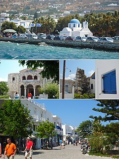
Paros is a Greek island in the central Aegean Sea. One of the Cyclades island group, it lies to the west of Naxos, from which it is separated by a channel about 8 kilometres wide. It lies approximately 150 km south-east of Piraeus. The Municipality of Paros includes numerous uninhabited offshore islets totaling 196.308 square kilometres (75.795 sq mi) of land. Its nearest neighbor is the municipality of Antiparos, which lies to its southwest. In ancient Greece, the city-state of Paros was located on the island.

Amiternum was an ancient Sabine city, then Roman city and later bishopric and Latin catholic titular see in the central Abruzzo region of modern Italy, located 9 km (5.6 mi) from L'Aquila. Amiternum was the birthplace of the historian Sallust.

The Battle of the Trebia was the first major battle of the Second Punic War, fought between the Carthaginian forces of Hannibal and a Roman army under Sempronius Longus on 22 or 23 December 218 BC. It took place on the flood plain of the west bank of the lower Trebia River, not far from the settlement of Placentia, and resulted in a heavy defeat for the Romans.
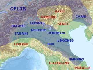
The Taurini were a Celto-Ligurian tribe dwelling in the upper valley of the river Po, around present-day Turin, during the Iron Age and the Roman period.

Gergovia was a Gaulish town in modern Auvergne-Rhône-Alpes in the upper part of the basin of the Allier, near present-day Clermont-Ferrand. It was the capital of the Averni. The city of Gergovia had strong walls, and was located on a giant raised plateau surrounded by hills.

Voghera is a town and comune in the Province of Pavia in the Italian region Lombardy. The population was 39,374 as of 2017. It is the third most populated town in the province, after Pavia and Vigevano. It is located 30 km south-southwest of that city, on the Staffora.
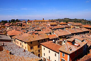
Chiusi is a town and comune in the province of Siena, Tuscany, Italy.
A Estrada is a municipality of the Pontevedra province in Galicia in northwestern Spain. It is located some 15 miles (24 km) southeast of Santiago de Compostela.
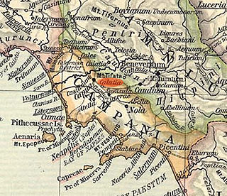
Cālātia was an ancient town of Campania, southern Italy, c. 10 km southeast of Capua, on the Via Appia, near the point where the Via Popillia branches off from it. It is represented by a locality known as Villa Galazia and by the church of San Giacomo alle Galazze, within the modern town of Maddaloni, very near the boundary with the neighboring town of San Nicola la Strada, and right on the Via Appia. The Via Appia here, as at Capua, abandons its former SE direction for a length of 2,000 Oscan feet (500 m), for which it runs due east and then resumes its course SE. Ruins include remains of the walls and the pre-Roman necropolis was partially excavated in 1882. The ten shafts lined with slabs of tuff which may have been the approaches to tombs or may have served as wells.

The Via Postumia was an ancient Roman road of northern Italy constructed in 148 BC by the consul Spurius Postumius Albinus Magnus. It ran from the coast at Genua through the mountains to Dertona, Placentia and Cremona, just east of the point where it crossed the Po River. From Cremona the road ran eastward to Bedriacum, the current town of Calvatone, where it forked, one branch running to the right to Mantua, the other to the left to Verona, crossing the Adige river on the Ponte Pietra, the only bridge on the Adige river at that time, and then traversing the Venetian plain, crossing the Piave River at Maserada sul Piave until finally reaching Aquileia, an important military frontier town founded by Rome in 181 BC. The Roman conquest of Liguria depended upon this road, and several of the more important towns owed their origin largely to it. Cremona was its central point, the distance being reckoned from it both eastwards and westwards.

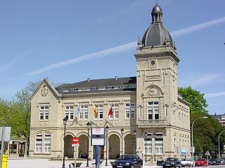
Opladen, now a district of Leverkusen, used to be the capital of the Rhein-Wupper-Kreis (Rhine-Wupper-District) until 1975. Opladen station is located 15 kilometres (9.3 mi) northeast from Cologne on the railway to Wuppertal. It is also on the Autobahn A3. Population (1905) was 6338, (1975) 42,000. It has several Evangelical and Roman Catholic churches. It used to have dyeing works, manufactures of dynamite, indigo products, publishing companies and a railway plant. Before passing to Prussia, Opladen belonged to the duchy of Berg.
Casteggio is a comune (municipality) in the Province of Pavia in the Italian region Lombardy, located about 61 km south of Milan and about 25 km south of Pavia. As of 31 July 2010, it had a population of 6,537 and an area of 17.8 km².
The Insubres or Insubri were an ancient Celtic population settled in Insubria, in what is now the Italian region of Lombardy. They were the founders of Mediolanum (Milan). Though completely Gaulish at the time of Roman conquest, they were the result of the fusion of pre-existing Ligurian and Celtic population with Gaulish tribes.

Luni is a comune (municipality) in the province of La Spezia, in the easternmost end of the Liguria region of northern Italy. It was founded by the Romans as Luna. It gives its name to Lunigiana, a region spanning eastern Liguria and northern Tuscany.
The Ilvates were a Ligurian tribe, whose name is found only in the writings of Livy. He mentions them first as taking up arms in 200 BCE, in concert with the Gaulish tribes of the Insubres and Cenomani, to destroy the Roman colonies of Placentia and Cremona. They are again noticed three years later as being still in arms, after the submission of their Transpadane allies; but in the course of that year's campaign they were reduced by the consul Quintus Minucius Rufus, and their name does not again appear in history. From the circumstances here related, it is clear that they dwelt on the north slopes of the Apennines, towards the plains of the Padus, and apparently not very far from Clastidium ; but we cannot determine with certainty either the position or extent of their territory. Their name, like those of most of the Ligurian tribes mentioned by Livy, had disappeared in the Augustan age, and is not found in any of the ancient geographers. Charles Athanase Walckenaer, however, supposed the Eleates over whom the consul Marcus Fulvius Nobilior celebrated a triumph in 159 BCE and who are in all probability the same people with the Veleiates of Pliny, to be identical also with the Ilvates of Livy; but this cannot be assumed without further proof.
Emilia is a historical region of northern Italy, which approximately corresponds to the western and north-eastern portions of the modern region Emilia-Romagna, with the area of Romagna forming the remainder of the modern region.
The Genoa–Milan railway is a major Italian rail line, connecting the cities of Genoa and Milan. It is 157 km (98 mi) long and fully electrified at 3,000 V DC. Passenger traffic is managed by Trenitalia.
References
- C. Giulietti, Casteggio, notizie storiche II. Avanzi di antichità, Voghera, 1893.
- This article incorporates text from a publication now in the public domain : Chisholm, Hugh, ed. (1911). "Clastidium". Encyclopædia Britannica . Vol. 6 (11th ed.). Cambridge University Press. p. 462.