
Clausentum was a small town in the Roman province of Britannia. The site is believed to be located in Bitterne Manor, which is now a suburb of Southampton.
Clausentum was a small town in the Roman province of Britannia. The site is believed to be located in Bitterne Manor, which is now a suburb of Southampton.
Route VII of the Antonine Itinerary [1] documents the Roman settlement of Clausentum as being 20 miles (32 km) west of Noviomagus Reginorum (Chichester) [1] and 10 miles (16 km) from Venta Belgarum (Winchester). [1] In 1610, William Camden identified Southampton as being the site of Clausentum and described how at Bitterne he had seen "old broken walls, and trenches of an ancient castle". [2] Around 1770, [3] John Speed [3] claimed that Clausentum was in the area that is now known as Bitterne Manor. [3] [4] In 1792, [3] the antiquary Richard Warner [3] investigated those claims and found a ditch, an earth bank and some Roman coins. [3] [5] Since then, this site has been investigated further and is generally accepted as the site of Clausentum, [3] but there is no universal agreement. [3]
Reference to modern maps shows Bitterne Manor to be 25 miles (40 km) from Chichester. Wickham is at the junction of two Roman Roads and is a better fit to the distances documented in Route VII of the Antonine Itinerary. [1] The case for Clausentum being situated at Bitterne Manor is based on archaeological evidence, [6] and the geography of the site (nestled inside a sharp bend in the River Itchen) which clearly allowed it to be turned into a good defensive position. [6] The fact that there was a Roman settlement at what is now Bitterne Manor is not disputed. [6]
The settlement is located on a promontory jutting into the River Itchen. [8] The first archaeological excavations were conducted in 1935, [9] and Molly Cotton undertook excavations from 1951 to 1954. [10] The excavations showed that it was the site of a small town in the 1st and 2nd centuries. [8] At a later date a stone defensive wall was erected around the site. The early excavators dated the erection of this wall to around 370, but later evidence showed that the walls were erected around 280–90, at about the same time as the fort at nearby Portchester (Portus Adurni). [8] Traces of a Roman road on a line running from Bitterne Manor to Wickham have also been found. [6]
Today, all that is visible are the fragmentary remains of a small 2nd-century bath house, and a fragment of the 3rd century fortified walls. [8] The baths consist of four rooms, later converted into a two-roomed structure. [11] They were demolished when the fortified wall was built at the end of the 3rd century. [11] The remains are located on private property, at Bitterne Manor House, and permission is needed to see them. [11]
Four Roman milestones and three possible milestones were found at Bitterne between 1800 and 1850. [9] Two are in the Tudor House and Garden in Southampton; the remainder are lost. [9] Other artifacts from Clausentum on display at SeaCity Museum in Southampton include an altar dedicated to the Celtic goddess Ancasta, a bronze Hercules with Celtic hair-style, and a pipe-clay Venus. [9]

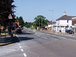
Wickham is a large village in the civil parish of Wickham and Knowle, in the Winchester district, in the county of Hampshire, England. It is about 3 miles north of Fareham. In 2021 it had a population of 2173. At the 2001 census, it the parish a population of 4,816, falling to 4,299 at the 2011 Census.

The River Itchen in Hampshire, England, rises to the south of New Alresford and flows 26 miles (42 km) to meet Southampton Water below the Itchen Bridge. The Itchen Navigation was constructed in the late 17th and early 18th centuries to enable barges to reach Winchester from Southampton Docks, but ceased to operate in the mid-19th century and is largely abandoned today.
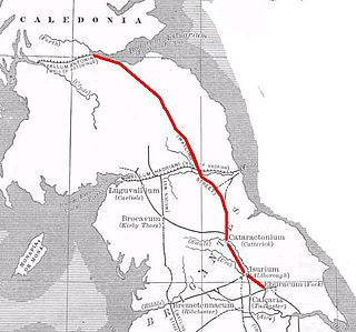
Dere Street or Deere Street is a modern designation of a Roman road which ran north from Eboracum (York), crossing the Stanegate at Corbridge and continuing beyond into what is now Scotland, later at least as far as the Antonine Wall. Portions of its route are still followed by modern roads, including the A1(M), the B6275 road through Piercebridge, where Dere Street crosses the River Tees, and the A68 north of Corbridge in Northumberland.
Hedge End is a town and civil parish in Hampshire, England. Situated to the east of the City of Southampton, it adjoins the districts of West End and Botley. Hedge End lies within the Borough of Eastleigh and is part of the Southampton Urban Area. The original hamlet developed on Botley Common after 1250 when it was granted to the men of Botley as common pasture. In 1267, royal charters allowed Botley to hold an annual fair and a weekly market on the common which eventually became a market town.
Weston is a small suburb on the south-eastern side of Southampton, UK, predominantly built on the Weston Grove Estate formerly owned by the Chamberlayne family. It also includes the area that was previously the Barnfield Estate. Weston includes part of Mayfield Park, which was previously the Mayfield Estate. Weston is bounded by Woolston, Sholing, Netley and Southampton Water.

Bitterne is an eastern suburb and ward of Southampton, England.

Northam is a suburb of Southampton in Hampshire. On the West bank of the River Itchen, it shares borders with St Mary's, Bitterne and Bevois Valley. Beside the border with St Mary's is the Chapel area, which has been home to some recent apartment building developments in Northam. The A3024 road runs through the suburb and crosses the Northam Bridge, which links Northam with Bitterne via Bitterne Manor. Although St Mary's Stadium takes its name from the neighbouring St Mary's, the stadium itself is in Northam, and home to Southampton F.C.

Bitterne Manor is a suburb of Southampton surrounding the manor house of the same name. It is located on the eastern bank of the River Itchen, across Cobden Bridge from St Denys.

Sholing, previously Scholing, is a district on the eastern side of the city of Southampton in Southern England. It is located between the districts of Bitterne, Thornhill and Woolston.


Southampton is a port city in Hampshire, England. It is located approximately 80 miles (130 km) south-west of London, 20 miles (32 km) west of Portsmouth, and 20 miles (32 km) south-east of Salisbury. Southampton had a population of 253,651 at the 2011 census, making it one of the most populous cities in southern England. Southampton forms part of the larger South Hampshire conurbation which includes the city of Portsmouth and the boroughs of Havant, Eastleigh, Fareham, and Gosport.
Southampton is a city in Hampshire, England. The area has been settled since the Stone Age. Its history has been affected by its geographical location, on a major estuary on the English Channel coast with an unusual double high-tide, and by its proximity to Winchester and London; the ancient and modern capitals of England. Having been an important regional centre for centuries, Southampton was awarded city status by Queen Elizabeth II in 1964 .

The Northam Bridge is a road bridge across the River Itchen in Southampton, England, linking the suburbs of Northam and Bitterne Manor. The current bridge was the first major prestressed concrete road bridge to be built in the United Kingdom. The bridge carries the A3024 road as a dual carriageway, with two lanes on each carriageway.

Itchen Ferry village was a small hamlet on the East bank of the River Itchen in Hampshire. The village took its name from the small fishing boats that were also used to ferry foot passengers across the river. An Ordnance Survey map of 1911 (NC/03/17894) shows the village to be situated in the area roughly bounded by Sea Road, Oakbank Road, the River Itchen and the railway line in modern Woolston, but also extending along Sea Road towards Peartree Green on the other side of the railway, which cut the village in half in 1866. Neighbouring streets on that same map, Defender Road, Britannia Road and Shamrock Road have a more structured layout and are clearly part of the Victorian enlargement of Woolston. The same map clearly shows the housing in Itchen Ferry village to have a more random layout. An even older map, of 1842 pins Itchen Ferry village more tightly to the area between Sea Road and Vicarage Road.

Peartree Green is an open space on high ground on the east bank of the River Itchen in Southampton. A 16/17th century building, Peartree House, still stands, though is today concealed by private housing. The house and the green take their name from a pear tree that grew near the parish church. Some of the original open space has been built on, but a large proportion remains as a recreational area. It contains a church and the remains of a boarding school. It overlooks the River Itchen to St Mary's Church in Southampton.
Cataractonium was a fort and settlement in Roman Britain. The settlement evolved into Catterick, located in North Yorkshire, England.
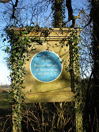
Sulloniacis or Sulloniacae was a mansio on the Roman road known as Watling Street in Roman Britain. Its existence is known from only one entry in the Antonine Itinerary, a listing of routes and facilities for the cursus publicus, the official courier service of the Roman Empire. Sulloniacis, which is recorded in Iter II for the route that ran between Portus Ritupis and Deva Victrix, was nine Roman miles from Verulamium and 12 from Londinium (London). Roman remains found at Brockley Hill near Edgware in the London Borough of Barnet have been identified as those of Sulloniacis.
History of Woolston, suburb of Southampton, Hampshire.

Derventio, sometimes described as Derventio Brigantium in order to distinguish it from other places called Derventio, was a Roman fort and settlement located beneath the modern town of Malton in North Yorkshire, England. The fort is positioned 18 miles north-east of Eboracum on the River Derwent.
Noviomagus, also known as Noviomagus Cantiacorum to distinguish it from other places with that name, was a Roman settlement in southeastern Britain. It is named on Iter II of the Antonine Itinerary, ten Roman miles from Londinium and nineteen to Vagniacis, thence nine miles to Durobrivae. Its location has been given as modern Crayford, but is now suggested to be near West Wickham following excavation of the Roman site there; the distances also fit West Wickham better than Crayford.