Related Research Articles

Clay County is located in the U.S. state of Missouri and is part of the Kansas City metropolitan area. As of the 2020 census, the county had a population of 253,335, making it the fifth-most populous county in Missouri. Its county seat is Liberty. The county was organized January 2, 1822, and named in honor of U.S. Representative Henry Clay from Kentucky, later a member of the United States Senate and United States Secretary of State. Clay County contains many of the area's northern suburbs, along with a substantial portion of the city of Kansas City, Missouri. It also owns and operates the Midwest National Air Center in Excelsior Springs.

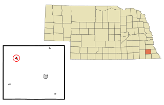
Clay County is a county in the U.S. state of Nebraska. As of the 2020 United States Census, the population was 6,104. Its county seat is Clay Center. The county was formed in 1855, and was organized in 1871. It was named for Henry Clay, a member of the United States Senate from Kentucky, who went on to become United States Secretary of State. In the Nebraska license plate system, Clay County is represented by the prefix 30.

Lancaster County is a county located in the U.S. state of Nebraska. As of the 2020 United States Census, the population was 322,608, making it the second-most populous county in Nebraska. Its county seat is Lincoln, the state capital. The county was created in 1859.

Webster County is a county in the U.S. state of Nebraska. As of the 2020 United States Census, the population was 3,411. Its county seat is Red Cloud. The county was formed in 1871, and was named for Daniel Webster.

Saline County is a county in the U.S. state of Nebraska. As of the 2020 United States Census, the population was 14,292. Its county seat is Wilber.

Lewis County is a county located in the U.S. state of Kentucky. As of the 2020 census, the population was 13,080. Its county seat is Vanceburg.

Jackson County is a county located in the northeastern part of the U.S. state of Georgia. As of the 2020 census, the population was 75,907. The county seat is Jefferson. Jackson County comprises the Jefferson, GA Micropolitan Statistical Area, which is included in the Atlanta-Athens-Clarke County-Sandy Springs, GA Combined Statistical Area.

Johnson is a city in Washington County, Arkansas, United States. The community is located in the Ozark Mountains and is surrounded by valleys and natural springs. Early settlers took advantage of these natural features and formed an economy based on mining lime, the Johnson Mill and trout. Although a post office was opened in the community in 1887, Johnson did not incorporate until it required the development of a city government to provide utility services in 1961. Located between Fayetteville and Springdale in the heart of the rapidly growing Northwest Arkansas metropolitan statistical area, Johnson has been experiencing a population and building boom in recent years, as indicated by a 46% growth in population between the 2000 and 2010 censuses.

Pike Creek is a census-designated place (CDP) in New Castle County, Delaware, United States and is part of the Philadelphia-Camden-Wilmington, PA-NJ-DE-MD Metropolitan statistical area. In 2007, CNN's Money Magazine ranked Pike Creek number 1 on its list of the 100 Best Places to Live in the United States. Pike Creek was the only community in Delaware to appear on the list. The population was 7,808 at the 2020 Census. Local attractions include Middle Run Natural Area, White Clay Creek State Park, Carousel Farm Park and Equestrian Center, Golf and Restaurants. Pike Creek is approximately five miles from downtown Newark, which contains the University of Delaware. Pike Creek is connected to the University of Delaware campus and the Newark downtown area by several bike trails. Pike Creek is approximately 10 miles west of the state's largest city, Wilmington, which is a national financial center.

Greenville is a city and the county seat of Meriwether County, Georgia, United States. The population was 794 at the 2020 census, down from 876 in 2010. The city is located 60 miles (97 km) southwest of Atlanta and is part of the Atlanta metropolitan area.

Catlettsburg is a home rule-class city in and the county seat of Boyd County, Kentucky, United States. The city population was 1,780 at the 2020 census. It is part of the Huntington–Ashland metropolitan area.
Sterling is a village in Johnson County, Nebraska, United States. The population was 482 at the 2020 census.

Orange Township is a township in Columbia County, Pennsylvania. It is part of Northeastern Pennsylvania. The population was 1,163 at the 2020 census.

Ridgway is a borough in and the county seat of Elk County, Pennsylvania. As of the 2020 census it had a population of 4,039

Chesterfield County Public Schools is the public school system of Chesterfield County, Virginia, United States. As of 2020, there are about 64,000 students enrolled in 66 schools. There are 40 elementary schools, 12 middle schools, and 10 high schools. Additionally, high school students can enroll in 13 specialty centers, two technical centers, one career academy, and two Governor's Schools.
The Fulton County School System is a school district headquartered in Sandy Springs, Georgia, United States. The system serves the area of Fulton County outside the Atlanta city limits. Fulton County Schools serve the cities of Alpharetta, Johns Creek, Milton, Mountain Park, Roswell, and Sandy Springs north of Atlanta, and Chattahoochee Hills, College Park, East Point, Fairburn, Hapeville, Palmetto, Union City, South Fulton, and Fulton's remaining unincorporated areas in the south. Fulton County is the fourth-largest school system in Georgia.
Jenks Public Schools is a PreK-12 public school system located in Jenks, Oklahoma.
Deer Creek Public Schools serves students in northwestern Oklahoma County and southwestern Logan County in Oklahoma. As of February 2024, the district enrolls 7,626 students.
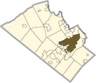
The Allentown School District is a large, urban public school district located in Allentown, Pennsylvania in the Lehigh Valley region of eastern Pennsylvania. The district is the fourth-largest school district in Pennsylvania as of the 2016-17 school year. The district includes almost all of Allentown.
Wilber Clatonia Public School District is located in Wilber, Nebraska, United States. It was founded in 1970 when Wilber High School and Clatonia High School consolidated, forming the Wilber Clatonia Public School District, which has 530 students (K-12). The high school enrollment is approximately 258 students.