Kingcome Inlet is one of the lesser principal fjords of the British Columbia Coast, north and east of Broughton Island. It is sixth in sequence of the major saltwater fjords north from the 49th parallel north near Vancouver and similar in width to longer inlets such as Knight Inlet and Bute Inlet, but it is only 35 km in length from the mouth of the Kingcome River to Sutlej Channel, which ultimately connects around Broughton Island to the main regional waterway of the Queen Charlotte Strait. Kingcome Inlet has a short side inlet, Wakeman Sound, fed by the Wakeman River.
Kwikwasut'inuxw Haxwa'mis, formerly the Kwicksutaineuk-ah-kwa-mish First Nation is a First Nations band government based on northern Vancouver Island in British Columbia, Canada, in the Queen Charlotte Strait region. It is a member of the Musgamagw Tsawataineuk Tribal Council, along with the ‘Namgis First Nation and the Tsawataineuk First Nation. The Kwikwasut'inuxw and Haxwa'mis are two of the many subgroups of the peoples known as Kwakwaka'wakw, which means "speakers of Kwak'wala", their language, and were combined into one band by the Department of Indian and Northern Affairs.
Clear River can refer to:
Kingcome, known as Gwa'yi in Kwak'wala, is an unincorporated settlement in the Kingcome Inlet area of the Central Coast of British Columbia, Canada, located a few miles up the Kingcome River from the head of the inlet. Quaee Indian Reserve No. 7 is the Indian reserve containing the village.
The Kingcome River is a river in the Canadian province of British Columbia. Its drainage basin is 1,456 square kilometres (562 sq mi) in size.
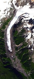
The Kingcome Glacier is a glacier located at the head of the Kingcome River in southwestern British Columbia, Canada.

The Monarch Icefield is the northernmost of a series of large continental icecaps studding the heights of the Pacific Ranges of the Coast Mountains in southern British Columbia. Located southeast of the town of Bella Coola and west of the headwaters of the Atnarko River, a tributary of the Bella Coola River, it lies to the north of the Ha-Iltzuk Icefield, which is the largest icefield of the group and home to the Silverthrone volcano. The Monarch Icefield is very remote and is rarely visited by mountaineering parties.
Simoom Sound is a sound on the Central Coast of British Columbia, Canada, located on the east and north sides of the Wishart Peninsula between Tribune Channel and Kingcome Inlet. The former steamer landing and current post office of Simoom Sound. The former steamer landing, now classified as a "locality" and the post office of Simoom Sound, British Columbia is named for the sound, which is located at Echo Bay on Gilford Island. Kawages Indian Reserve No. 4 is located on the north side of Simoom Sound and is a reserve of the Dzawada'enuxw First Nation of the Kwakwaka'wakw peoples.
Wakeman Sound is a sound on the South Coast of British Columbia, Canada, located in the area north of the Broughton Archipelago, which lies on the north side of Queen Charlotte Strait, on the northeast side of Broughton Island. It is a sidewater opening of and opening north off Kingcome Inlet.

Kingcome Inlet is a locality on the Central Coast region of British Columbia, located on the inlet of the same name.
Theodosia Inlet is an inlet in the Desolation Sound region of the South Coast region of British Columbia, Canada, located east of Lancelot Inlet, a sub-inlet of Malaspina Inlet. The inlet is fed by the Theodosia River. The locality of Theodosia Arm is located near its outlet at the head of Thors Cove.
Bond Sound is a sound located on the northeast side of Tribune Channel in the Central Coast region of British Columbia. Bond Sound, with the head of Kingcome Inlet to its north, frames the Wishart Peninsula. Like other names in the area, it was named by Captain Pender in 1865, in association with other names in the area associated with HMS Tribune.
The Ahta River is a river in the Central Coast of British Columbia, flowing into Bond Sound to the south via the short Ahta Valley, which connects to the head of Kingcome Inlet to the north.
The Kingcome Range is a subrange of the Pacific Ranges of the Coast Mountains, located to the east of Kingcome Inlet.
Kingcome Point is a headland on the northwest tip of Princess Royal Island in the North Coast region of British Columbia, Canada.
The Wakeman River is a river in the western Pacific Ranges on the Central Coast region of British Columbia, Canada, flowing south into Wakeman Sound, which is a sidewater of Kingcome Inlet.
Waluk was a Kwakwaka'wakw village of the Tsawataineuk group located at Anchorage Cove on the south shore of the head of Kingcome Inlet in the Central Coast region of British Columbia, Canada. The site was used for timber harvesting, fishing and trapping.
The Atlatzi River is a river in the Pacific Ranges in the Central Coast region of British Columbia, Canada, flowing southwest into the lower Kingcome River, which feeds the head of Kingcome Inlet. It had been called Back River on a 1919 map of British Columbia. Its headwaters are at 51°03′N125°52′W.
The Satsalla River is a river in the Pacific Ranges of the Coast Mountains in British Columbia, Canada, flowing southwest into the Kingcome River. Like the Atlatzi River, another major tributary of the Kingcome farther south, its origins are on the edge of the Ha-Iltzuk Icefield.


