The Shetucket River is a tributary of the Thames River, 20.4 miles (32.8 km) long, in eastern Connecticut in the United States.

The Skykomish River is a Washington river which drains the west side of the Cascade Mountains in the southeast section of Snohomish County and the northeast corner of King County. The river starts with the confluence of the North Fork Skykomish River and South Fork Skykomish River approximately one mile west of Index, then flowing northwesterly towards Puget Sound. It is joined by the Sultan River and the Wallace River at Sultan. It then meets the Snoqualmie River to form the Snohomish River at Monroe. The Snohomish River continues along the river valley eventually dumping into Port Gardner Bay on Possession Sound.

Piscataway Creek is an 18.6-mile-long (29.9 km) tributary of the Potomac River in Prince George's County, Maryland. The creek is a tidal arm of the Potomac for its final 2.5 miles (4.0 km), entering the Potomac at Fort Washington Park. Tinkers Creek is a tributary to Piscataway Creek, converging from the north 4.5 miles (7.2 km) upstream of the mouth of the Piscataway. The United States Geological Survey records two variant names for Piscataway Creek: Pascattawaye Creek and Puscattuway Creeke.

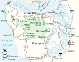
The Quinault River is a 69-mile (111 km) long river located on the Olympic Peninsula in the U.S. state of Washington. It originates deep in the Olympic Mountains in the Olympic National Park. It flows southwest through the "Enchanted Valley" to opposite Quinault Canyon. Several miles above Lake Quinault the river is joined by its main tributary, the North Fork Quinault River. The main stem Quinault River above this confluence is sometimes called the East Fork Quinault River. Below the confluence the river marks the boundary of Olympic National Park for several miles before emptying into Lake Quinault. After the lake, the Quinault River flows southwest, reaching the Pacific at Taholah. From Lake Quinault to the ocean, the river is contained within the Quinault Indian Reservation.
Little Conococheague Creek is a 12.4-mile-long (20.0 km) tributary stream of the Potomac River in the U.S. states of Maryland and Pennsylvania. The stream rises on Two Top Mountain, west of the Whitetail Ski Resort in Franklin County, Pennsylvania, and proceeds south into Washington County, Maryland. It empties into the Potomac about 2 miles (3 km) southeast of Big Spring, Maryland. The watershed of the creek is 18 square miles (47 km2) and includes Indian Springs Wildlife Management Area. Tributaries include Toms Run.
The Salmon River is a tributary of the Queets River in U.S. state of Washington.
A hydrological code or hydrologic unit code is a sequence of numbers or letters that identify a hydrological feature like a river, river reach, lake, or area like a drainage basin or catchment.
The Wallace River is a medium-sized river in Washington, United States. It is a tributary of the Skykomish River and joins near Sultan, just upstream from the mouth of the Sultan River. The Wallace River is 15 miles (24 km) long. Its drainage basin is 30 square miles (78 km2) in area.

The Moclips River is a river in the U.S. state of Washington. It is about 12 miles (19 km) long. Its main tributary, the North Fork Moclips River, is longer than the main stem. The length of the North Fork, along with the lower main stem below the North Fork's confluence, is 17 miles (27 km). The drainage basin of the Moclips River is 22.4 square miles (58 km2) in area.
The Middle Branch Pleasant River is a tributary of the Piscataquis River in Piscataquis County, Maine. From the outflow of Middle Branch Pond in Maine Township 5, Range 9, WELS, the river runs 11.4 miles (18.3 km) southeast to its confluence with the East Branch in Brownville. The East Branch runs about 1.5 miles (2.4 km) further south, joining with the West Branch to form the main stem of the Pleasant River.
The West Branch Piscataquis River is a 22-mile-long (35 km) tributary of the Piscataquis River in Piscataquis County, Maine. Its source is in East Moxie, Somerset County . The river runs about 6 miles (10 km) east, then 11 miles (18 km) south, then 5 miles (8 km) east to its confluence with the East Branch Piscataquis River in Blanchard to form the Piscataquis.

The Beckler River is a tributary of the South Fork Skykomish River in the U.S. state of Washington in the United States.
The Rapid River is a tributary of the Beckler River in the U.S. state of Washington in the United States. It is 13 miles (21 km) long, with a drainage basin of 41 square miles (106 km2).

The Clearwater River is in the northwestern United States, in north central Idaho. Its length is 74.8 miles (120.4 km), it flows westward from the Bitterroot Mountains along the Idaho-Montana border, and joins the Snake River at Lewiston. In October 1805, the Lewis and Clark Expedition descended the Clearwater River in dugout canoes, putting in at "Canoe Camp," five miles (8 km) downstream from Orofino; they reached the Columbia Bar and the Pacific Ocean about six weeks later.
Sams River is a river in the U.S. state of Washington. A tributary of the Queets River, Sams River flows through Olympic National Park and Olympic National Forest. Part of the river's lower course forms the boundary between the national park and national forest.
The Snahapish River is a river in the U.S. state of Washington. It is a tributary of the Clearwater River, which in turn flows into the Queets River.
The Solleks River is a river in the U.S. state of Washington. It is a tributary of the Clearwater River, which in turn flows into the Queets River.
Goodman Creek is a stream in the U.S. state of Washington.