Cleaver Bank

Last updated
Location of the Cleaver Bank (Dutch: Klaverbank
, in reference to the Dogger Bank and the Dutch coast. Noordzeegebieden.jpg
Location of the Cleaver Bank (Dutch : Klaverbank, in reference to the Dogger Bank and the Dutch coast.
North Sea map-en.png
175-free-google-maps-pointer.svg
Cleaver Bank


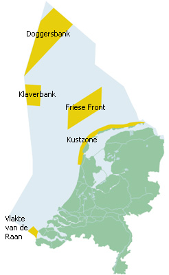
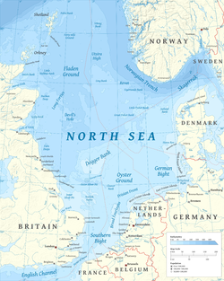
The Cleaver Bank (Dutch: Klaverbank) is a sandbank in the North Sea about 160 kilometres (99 miles) off the west coast of the Netherlands and south of the Dogger Bank. The size of the bank is about 1235 km2. The bank is 30-40 metres below sea level. [1]

The Cleaver Bank is an open-sea reef in the terms of the European Habitats directive and has been registered with the European Union as a Natura 2000 site. The bank originated as a terminal moraine of a glacier during one of the Ice Ages. [2]

The surface of the bank partly consists of gravel and larger cobbles. Due to the relatively great depth of the Cleaver Bank, the soil is only seldom, in very heavy weather, moved by wave action. [3] Because the gravel is relatively poor in silt and the transparency is great, there is enough light to allow for the growth of calcareous red algae. [3] The benthic fauna on the bank contains species that live on a hard substrate, such as sea anemones and polyps. [4] Rare species living on Cleaver Bank are Thracia convexa and the Rayed artemis. The bank is used by herring for spawning. [4] In addition, the soft coral type dead man's finger is found here.

A 60-metre-deep channel, called the Botney Cut, runs through the Cleaver Bank. Animals like harbour porpoises, minke whales, and white-beaked dolphin live there, mainly in the summer. [3]

Conservation

In 2001, the Dutch government considered the Cleaver Bank as a potential area for mining gravel. [5] After making an Environmental impact assessment the plan was abandoned. [6] The Cleaver bank is in 2015 considered for protection as a Marine protected area. The Greenpeace organisation considered the actions of the Dutch government in this direction too slow and sunk some large boulders on the seabed in May 2015 to increase the nature value. [7] Dutch fishers lifted the boulders on 16 June 2015, because they were afraid the boulders would damage their fishing gear. [8]

Related Research Articles

<span class="mw-page-title-main">North Sea</span> Marginal sea of the Atlantic Ocean

The North Sea lies between Great Britain, Denmark, Norway, Germany, the Netherlands, Belgium and France. An epeiric sea on the European continental shelf, it connects to the Atlantic Ocean through the English Channel in the south and the Norwegian Sea in the north. It is more than 970 kilometres (600 mi) long and 580 kilometres (360 mi) wide, covering 570,000 square kilometres (220,000 sq mi).

<span class="mw-page-title-main">Geography of the Netherlands</span> Overview of the geography of the European Netherlands

The geography of the European Netherlands is unusual in that much of its land has been reclaimed from the sea and is below sea level, protected by dikes. It is a small country with a total area of 41,545 km2 (16,041 sq mi) and ranked 131st. With a population of 17.4 million and density of 521/km2 (1,350/sq mi) makes it the second most densely populated member of the European Union after Malta, and the 12th most densely populated country in the world, behind only three countries with a population over 16 million. Consequently, the Netherlands is highly urbanized.

<span class="mw-page-title-main">North Holland</span> Province of the Netherlands

North Holland is a province of the Netherlands in the northwestern part of the country. It is located on the North Sea, north of South Holland and Utrecht, and west of Friesland and Flevoland. As of January 2023, it had a population of about 2,952,000 and a total area of 4,092 km2 (1,580 sq mi), of which 1,429 km2 (552 sq mi) is water.

<span class="mw-page-title-main">Bonaire</span> Dutch Caribbean island

Bonaire is a Caribbean island in the Leeward Antilles, and is a special municipality of the Netherlands. Its capital is the port of Kralendijk, on the west (leeward) coast of the island. Aruba, Bonaire and Curaçao form the ABC islands, 80 km off the coast of Venezuela. Unlike much of the Caribbean region, the ABC islands lie outside Hurricane Alley. The islands have an arid climate that attracts visitors seeking warm, sunny weather all year round. Bonaire is a popular snorkeling and scuba diving destination because of its multiple shore diving sites and easy access to the island's fringing reefs.

<span class="mw-page-title-main">Oostvaardersplassen</span> Nature reserve in the Netherlands

The Oostvaardersplassen is a nature reserve in the Netherlands, managed by the Staatsbosbeheer. Covering about 56 square kilometres (22 sq mi) in the province of Flevoland, it is an experiment in rewilding. It is in a polder created in 1968; by 1989, its ecological interest had resulted in its being declared a Ramsar wetland. It became part of Nieuw Land National Park when that was established in 2018.

<span class="mw-page-title-main">Radio 538</span> Dutch radio station

Radio 538 is a Dutch commercial radio station that was founded in Hilversum, Netherlands in 1992. It is the second-most listened to radio station in the Netherlands. Radio 538 refers to the wavelength on which Radio Veronica used to broadcast in the 1970s. The station is owned by Talpa Network. Mostly targeting a young audience, the station plays a mix of music from the decades 1980s to today, currently genres were dance, R&B, pop, and rock music. The music selection is mainly based on the Dutch Top 40 chart. Its breakfast and drive-time shows are talk-intensive.

<span class="mw-page-title-main">Dogger Bank</span> Large sandbank in the North Sea

Dogger Bank is a large sandbank in a shallow area of the North Sea about 100 kilometres (62 mi) off the east coast of England.

<span class="mw-page-title-main">Port of Rotterdam</span> Seaport in the Netherlands

The Port of Rotterdam is the largest seaport in Europe, and the world's largest seaport outside of East Asia, located in and near the city of Rotterdam, in the province of South Holland in the Netherlands. From 1962 until 2004, it was the world's busiest port by annual cargo tonnage. It was overtaken first in 2004 by the port of Singapore, and since then by Shanghai and other very large Chinese seaports. In 2020, Rotterdam was the world's tenth-largest container port in terms of twenty-foot equivalent units (TEU) handled. In 2017, Rotterdam was also the world's tenth-largest cargo port in terms of annual cargo tonnage.

<span class="mw-page-title-main">Deep-water coral</span> Marine invertebrates

The habitat of deep-water corals, also known as cold-water corals, extends to deeper, darker parts of the oceans than tropical corals, ranging from near the surface to the abyss, beyond 2,000 metres (6,600 ft) where water temperatures may be as cold as 4 °C (39 °F). Deep-water corals belong to the Phylum Cnidaria and are most often stony corals, but also include black and thorny corals and soft corals including the Gorgonians. Like tropical corals, they provide habitat to other species, but deep-water corals do not require zooxanthellae to survive.

<span class="mw-page-title-main">Duinen van Texel National Park</span>

Duinen van Texel National Park is a national park located on the North Holland island of Texel in the Netherlands. All dune systems on the western side of the island and the large coastal plains on both the northern and southern points of the island are part of the park. The park covers approximately 43 km2 (17 sq mi) and attained national park status in 2002. The visitor center is located in the natural history museum Ecomare.

<span class="mw-page-title-main">Wind power in the Netherlands</span>

As of November 2023, wind power in the Netherlands has an installed capacity of 11,602 MW, 40.9% of which is based offshore. In 2022, the wind turbines provided the country with 18.37% of its electricity demand during the year. Windmills have historically played a major part in the Netherlands by providing an alternative to water driven mills.

<span class="mw-page-title-main">White Island, Isles of Scilly</span> Island of Great Britain

White Island is one of the larger unpopulated islands of the Isles of Scilly, part of the United Kingdom, and lies off the coast of the northernmost populated island of the group, St Martin's, to which it is joined by a tidal causeway, or isthmus. The island is designated as a Site of Special Scientific Interest (SSSI) and a Geological Conservation Review site and is managed by the Isles of Scilly Wildlife Trust on behalf of the Duchy of Cornwall.

<span class="mw-page-title-main">Geology of Cape Town</span> Geological formations and their history in the vicinity of Cape Town

Cape Town lies at the south-western corner of the continent of Africa. It is bounded to the south and west by the Atlantic Ocean, and to the north and east by various other municipalities in the Western Cape province of South Africa.

The Condor seamount is a submarine mountain located at 17 kilometres (11 mi) west-southwest of Faial Island in the Azores. It is approximately 1,800 metres (5,900 ft) high, 39 kilometres (24 mi) long and 23 kilometres (14 mi) wide, stretching from a depth of 185 metres (607 ft) up to 2,003 metres (6,572 ft). It is an elongated shaped volcano, oriented east-west, with the top relatively flat with smooth sedimentary flanks. Most seamounts lie in deep sea and/or open ocean, and thus are inaccessible and difficult to study. The Condor bank, constitutes an interesting case study due to its accessibility, located close to Faial island.

<i>Redbad</i> (film) 2018 film

Redbad is a 2018 Dutch drama film directed by Roel Reiné. It is based on the life of Radbod, an early medieval Frisian leader. The film was intended as the middle part of a trilogy about iconic Dutch/Frisian heroes, starting with the film Michiel de Ruyter, about the 17th century admiral Michiel de Ruyter and ending with an unmade film about William of Orange.

The Northern European Enclosure Dam (NEED) is a proposed solution to the problem of rising ocean levels in Northern Europe. It would be a megaproject, involving the construction of two massive dams in the English Channel and the North Sea; the former between France and England, and the latter between Scotland and Norway. The concept was conceived by the oceanographers Sjoerd Groeskamp and Joakim Kjellsson.

Mulciber is an extinct volcano on the Dutch part of the North Sea, about 100 km Northwest of Terschelling.

<span class="mw-page-title-main">Climate change in the Netherlands</span> Emissions, impacts and responses of the Netherlands related to climate change

The Netherlands is already affected by climate change. The average temperature in the Netherlands rose by more than 2 °C from 1901 to 2020. Climate change has resulted in increased frequency of droughts and heatwaves. Because significant portions of the Netherlands have been reclaimed from the sea or otherwise are very near sea level, the Netherlands is very vulnerable to sea level rise.

<span class="mw-page-title-main">Merijn Tinga</span> Dutch environmental activist

Merijn Tinga is a Dutch environmental activist. As the Plastic Soup Surfer he campaigned for reducing plastic pollution and the plastic soup.

References

  1. "Klaverbank | Stichting De Noordzee". www.noordzee.nl. Retrieved 2015-06-16.
  2. "North Sea Pelagic". www.worldnature55.com. Retrieved 2015-06-16.
  3. 1 2 3 "Noordzeeloket | Rijksoverheid | Klaverbank". www.noordzeeloket.nl. Archived from the original on 2014-06-20. Retrieved 2015-06-16.
  4. 1 2 "Cleaverbank". www.ecomare.nl. Retrieved 2015-06-16.
  5. "Klaverbank". www.ecosub.nl. Retrieved 2015-06-16.
  6. "Grindwinning". www.ecomare.nl. Retrieved 2015-06-16.
  7. "Greenpeace bouwt vissenparadijs op de Klaverbank" . Retrieved 2015-06-16.
  8. "Vissers ruimen keien Greenpeace | NOS". nos.nl. Retrieved 2015-06-16.