The village or hamlet of Gatehead is located in East Ayrshire, Parish of Kilmaurs, Scotland. It is one and a quarter miles from Crosshouse and one and a half miles from Kilmarnock. In the 18th and 19th centuries the locality was a busy coal mining district. The settlement runs down to the River Irvine where a ford and later a bridge was located.

Lambroughton Loch or Wheatrig Loch was situated in a low-lying area between the farms and dwellings of Hillhead, Lambroughton, Wheatrig, Titwood and Lochridge mainly in the Parish of Dreghorn, North Ayrshire. The loch was mainly fed by the Lochridge Burn, the Garrier Burn and surface runoff, such as from the old rig and furrows indicated by Roy's maps of the mid-18th century. The loch outflow was via the Lochridge Burn that runs into the Garrier Burn, passes the site of the old Lochend habitation and into the Bracken Burn near Little Alton. The rivulet or watercourse is known as the Garrier Burn beyond this point.
Lochlea or Lochlie was situated in a low-lying area between the farms and dwellings of Lochlea and Lochside in the Parish of Tarbolton, South Ayrshire, Scotland. The loch was natural, sitting in a hollow created by glaciation. The loch waters ultimately drained via Fail Loch, the Mill Burn, and the Water of Fail. It is well-documented due to the presence of a crannog that was excavated and documented circa 1878, and its association with the poet Robert Burns, who lived here for several years whilst his father was the tenant. Lochlea lies 2+1⁄2 miles northeast of Tarbolton, and just over three miles northwest of Mauchline.
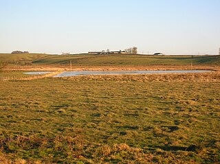
Buiston Loch, also known as Buston, Biston, and Mid Buiston was situated in the mid-Ayrshire clayland at an altitude of 90 m OD. The loch was natural, sitting in a hollow created by glaciation. The loch waters drained via the Garrier Burn that joins the Bracken and Lochridge Burns before joining the River Irvine.
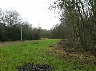
Littlestane Loch, was situated in the mid-Ayrshire clayland near Stanecastle, Irvine, North Ayrshire, Scotland. It is nowadays (2011) only visible as an area of permanent water in the Scottish Wildlife Trust Sourlie Nature Reserve. The loch was natural, sitting in a hollow created by glaciation. The loch waters outflow was via the Red Burn that flows into the River Garnock. The site of Littlestane Loch site is partly built over and much of the site is now public open space lying within the Parish of Girdle Toll.
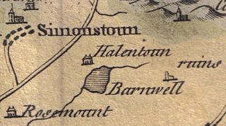
Helenton Loch was situated in a low lying area between the farms and dwellings of Helentongate, Mains, and Burnbank in the Parish of Symington, South Ayrshire, Scotland. The loch was natural, sitting in a hollow, a kettle hole, created by glaciation. The loch waters ultimately drained via the Pow Burn. Helenton Hill is a prominent landmark to the west of the old loch site. The nearby lands of Rosemount were in 1549 known as 'Goldring' and were the property of the Schaws of Sornbeg.

Trindlemoss Loch, Scott's / Scot's Loch or the Loch of Irvine was situated in a low-lying area running from Ravenspark to near Stanecastle and down to Lockwards, now represented only by the playing fields off Bank Street in the Parish of Irvine, North Ayrshire, Scotland. The loch was natural, sitting in a hollow created by glaciation. The loch waters were progressively drained and in 1691 this was finally achieved.

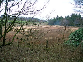
Fail Loch or Faile Loch was situated in a low-lying area near the old monastery of Fail in the Parish of Tarbolton, South Ayrshire, Scotland. The old Lochlea Loch lies nearby and its waters still feed into Fail Loch via the Mill Burn.
Hessilhead Loch or Hazelhead Loch was situated in a low-lying area near the old Castle of Hessilhead in the Parish of Beith, North Ayrshire, Scotland. The old loch, used in the defence of the castle, was probably infilled when the castle ruins were landscaped in the 19th century.

Knockewart Loch or Loch Jargon was situated in a hollow lying area beneath Knockewart Hill in the Parish of Ardrossan, North Ayrshire, Scotland. The old loch has become largely drained and overgrown since the late 19th century.

The Blae Loch is a small freshwater loch situated in a hollow in a low-lying area beneath Blaelochhead Hill in the Parish of Beith, North Ayrshire, Scotland.

The Galrigs Loch was a substantial freshwater loch situated in low lying area between Newfield and Dundonald in South Ayrshire, Scotland. It was drained in the early 18th century.

The Loch of Trabboch or Dalrympleston Loch (NS440211) was situated in a low-lying area below the old Castle of Trabboch, once held by the Boyd family in the Parish of Stair, East Ayrshire, Scotland.
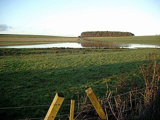
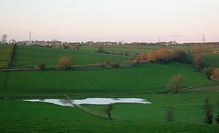
The Loch of Stair was a typical Ayrshire post-glacial 'Kettle Hole', situated in a low-lying area below the farm of Loch Hill, in the Parish of Stair, East Ayrshire, Scotland. This freshwater loch was drained in the 19th century, leaving a wetland area which still periodically floods.

Carcluie Loch is a small freshwater loch in the South Ayrshire Council Area, lying in a glacial Kettle Hole, Parish of Dalrymple, Scotland.
Plaid Loch was a freshwater loch in East Ayrshire, now a remnant due to drainage, near Sinclairston and 2 miles (3 km) south-east of Drongan, lying in a glacial kettle hole,.
South Palmerston Loch or Flush, previously known as Loch of the Hill, lying to the east of the 500 ft Back hill Mount. It was one of several small lochs within the Parish of Ochiltree. The loch, lying in a glacial kettle hole, drained into the Lugar Water via the Burnock Water.
Loch Shield, originally Loch of Scheel was a freshwater loch in the East Ayrshire Council Area, now drained, near Drongan, lying in a glacial Kettle Hole, Parish of Ochiltree, Scotland.
Loans is a village in South Ayrshire near Troon, Scotland. It is located in Dundonald parish on the A759 at the junction with the B746 and a minor road to Dundonald.
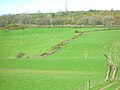
What now survives of the old Caprington Loch (NS402352) is situated near Earlston, Riccarton, East Ayrshire, Scotland. The loch was a natural feature, sitting in a hollow on the old Caprington Castle estate. The loch waters drain via the Todrigs Burn that flows into the River Irvine to the east of Gatehead village. It was partly drained, probably sometime after the 1820s, as were so many other lochs, as part of 18th and 19th centuries extensive agricultural improvements and the only area of open water that remains does so as it was once used as a curling pond for the Caprington Castle Estate owners and their employees or tenants.