
Saint Pierre and Miquelon, officially the Territorial Collectivity of Saint-Pierre and Miquelon, is a self-governing territorial overseas collectivity of France in the northwestern Atlantic Ocean near the Canadian province of Newfoundland and Labrador. An archipelago of eight islands, Saint Pierre and Miquelon is a vestige of the once-vast territory of New France. Its residents are French citizens; the collectivity elects its own deputy to the National Assembly and participates in senatorial and presidential elections. It covers 242 km2 (93 sq mi) of land and had a population of 6,008 as of the March 2016 census.
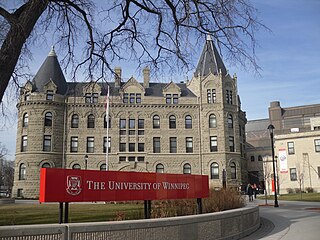
Winnipeg is the capital and largest city of the province of Manitoba in Canada. It is centred on the confluence of the Red and Assiniboine rivers, near the longitudinal centre of North America. As of 2021, Winnipeg had a city population of 749,607 and a metropolitan population of 834,678, making it Canada's sixth-largest city and eighth-largest metropolitan area.

Wind chill or windchill is the lowering of body temperature due to the passing flow of lower-temperature air.

The Human Development Index (HDI) is a statistical composite index of life expectancy, education, and per capita income indicators, which is used to rank countries into four tiers of human development. A country scores a higher level of HDI when the lifespan is higher, the education level is higher, and the gross national income GNI (PPP) per capita is higher. It was developed by Pakistani economist Mahbub ul-Haq and was further used to measure a country's development by the United Nations Development Programme (UNDP)'s Human Development Report Office.

A tornado warning is a public warning that is issued to an area in the direct path of a tornado or a thunderstorm capable of producing a tornado. They are issued by weather forecasting agencies in some countries when an actual tornado or signs of a developing tornado, such as a funnel cloud or wall cloud, are reported by weather spotters, the public, or detected by weather radar.

Isachsen is a remote Arctic research-weather station named after the Norwegian explorer of the Arctic, Gunnar Isachsen. It is on the western shore of Ellef Ringnes Island in the Sverdrup Islands, in the territory of Nunavut in Canada. Isachsen Station was established to participate in a joint Canadian-American weather observation program. Isachsen Station operated from April 3, 1948, through September 19, 1978. Regular weather observations began on May 3, 1948. In October 1949, a Douglas C-47 Skytrain crash-landed near the station. No one was killed, but three on board were injured. The wreckage has been preserved by the cold weather and dry conditions.

Crime in Canada is generally considered low overall. Under the Canadian constitution, the power to establish criminal law and rules of investigation is vested in the federal Parliament. The provinces share responsibility for law enforcement, and while the power to prosecute criminal offences is assigned to the federal government, responsibility for prosecutions is delegated to the provinces for most types of criminal offences. Laws and sentencing guidelines are uniform throughout the country, but provinces vary in their level of enforcement.

An air quality index (AQI) is an indicator developed by government agencies to communicate to the public how polluted the air currently is or how polluted it is forecast to become. As air pollution levels rise, so does the AQI, along with the associated Public health risk. Children, the elderly, and individuals with respiratory or cardiovascular problems are typically the first groups affected by poor air quality. When the AQI is high, governmental bodies generally encourage people to reduce physical activity outdoors, or even avoid going out altogether. When wildfires result in a high AQI, the use of masks such as N95 respirators outdoors and air purifiers incorporating HEPA filters indoors are also encouraged.
Corporate Knights is a media and research company based in Toronto, Canada, focused on advancing a sustainable economy. The company publishes a magazine, Corporate Knights, and produces global rankings, research reports, and financial product ratings based on corporate and environmental sustainability performance, including the "Global 100 Most Sustainable Corporations in the World" and the "Best 50 Corporate Citizens in Canada".
The pavement condition index (PCI) is a numerical index between 0 and 100, which is used to indicate the general condition of a pavement section. The PCI is widely used in transportation civil engineering and asset management, and many municipalities use it to measure the performance of their road infrastructure and their levels of service. It is a statistical measure and requires manual survey of the pavement. This index was originally developed by the United States Army Corps of Engineers as an airfield pavement rating system, but later modified for roadway pavements and standardized by the ASTM. The surveying processes and calculation methods have been documented and standardized by ASTM for both roads and airport pavements:

The Fragile States Index is an annual report mainly published and supported by the United States think tank the Fund for Peace. The FSI is also published by the American magazine Foreign Policy from 2005 to 2018, then by The New Humanitarian since 2019. The list aims to assess states' vulnerability to conflict or collapse, ranking all sovereign states with membership in the United Nations where there is enough data available for analysis. Taiwan, Northern Cyprus, Kosovo and Western Sahara are not ranked, despite being recognized as sovereign by one or more other nations. The Palestinian Territories were ranked together with Israel until 2021. Ranking is based on the sum of scores for 12 indicators. Each indicator is scored on a scale of 0 to 10, with 0 being the lowest intensity and 10 being the highest intensity, creating a scale spanning 0−120.

North Dakota's climate is typical of a continental climate with cold winters and warm-hot summers. The state's location in the Upper Midwest allows it to experience some of the widest variety of weather in the United States, and each of the four seasons has its own distinct characteristics. The eastern half of the state has a humid continental climate with warm to hot, somewhat humid summers and cold, windy winters, while the western half has a semi-arid climate with less precipitation and less humidity but similar temperature profiles. The areas east of the Missouri River get slightly colder winters, while those west of the stream get higher summer daytime temperatures. In general, the diurnal temperature difference is prone to be more significant in the west due to higher elevation and less humidity.
The Environmental Vulnerability Index (EVI) is a measurement devised by the South Pacific Applied Geoscience Commission (SOPAC), the United Nations Environment Program and others to characterize the relative severity of various types of environmental issues suffered by 243 enumerated individual nations and other geographies. The results of the EVI are used to focus on planned solutions to negative pressures on the environment, whilst promoting sustainability.

The United States' contiguous western and especially southwestern region has experienced widespread drought since about year 2000. Below normal precipitation leads to drought, and is caused by an above average persistence of high pressure over the affected area. Changes in the track of extratropical cyclones, which can occur during climate cycles such as the El Niño-Southern Oscillation, or ENSO, as well as the North Atlantic Oscillation, Pacific Decadal Oscillation, and Atlantic multidecadal oscillation, modulate which areas are more prone to drought. Increased drought frequency and severity is also expected to be one of the effects of global warming.
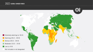
The Global Hunger Index (GHI) is a tool that attempts to measure and track hunger globally as well as by region and by country, prepared by European NGOs of Concern Worldwide and Welthungerhilfe. The GHI is calculated annually, and its results appear in a report issued in October each year.
QS World University Rankings is a portfolio of comparative university rankings compiled by global higher education analyst Quacquarelli Symonds (QS). Its first and earliest edition was published in collaboration with Times Higher Education (THE) magazine as Times Higher Education–QS World University Rankings, inaugurated in 2004 to provide an independent source of comparative data about university performance. In 2009, the two organizations parted ways to produce independent university rankings, the QS World University Rankings and THE World University Rankings.

Most of Sweden has a temperate climate, despite its northern latitude, with largely four distinct seasons and mild temperatures throughout the year. The winter in the far south is usually weak and is manifested only through some shorter periods with snow and sub-zero temperatures, autumn may well turn into spring there, without a distinct period of winter. The northern parts of the country have a subarctic climate while the central parts have a humid continental climate. The coastal south can be defined as having either a humid continental climate using the 0 °C isotherm, or an oceanic climate using the –3 °C isotherm.

The Climate Change Performance Index (CCPI) is a scoring system designed by the German environmental and development organisation Germanwatch e.V. to enhance transparency in international climate politics. On the basis of standardised criteria, the index evaluates and compares the climate protection performance of 63 countries and the European Union (EU), which are together responsible for more than 90% of global greenhouse gas (GHG) emissions.

The Good Country Index measures how much each of the 163 countries on the list contribute to the planet, and to the human race, through their policies and behaviors.
