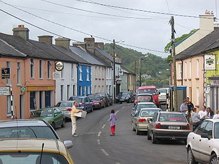
Union Hall is a small fishing village located in County Cork, Ireland, located on the west side of Glandore Harbour. Its nearest neighbour to the west is Castletownshend; to the east, Glandore Village. It is approximately 10 kilometers east of Skibbereen. As of the 2016 census, 270 people were living in Union Hall.

Gorey is a market town in north County Wexford, Ireland. It is beside the main M11 Dublin to Wexford road. The town is also connected to the railway network along the same route. Local newspapers include the Gorey Guardian and Gorey Echo.
Kanturk is a town in the north west of County Cork, Ireland. It is situated at the confluence of the Allua (Allow) and Dallow (Dalua) rivers, which stream further on as tributaries to the River Blackwater. It is about 50 kilometres from Cork, Blarney and Limerick, and lies just north of the main N72 road, 15 km from Mallow and about 40 km from Killarney. Kanturk is within the Cork North-West Dáil constituency.

Ballintra is a village in the parish of Drumholm in the south of County Donegal, Ireland, just off the N15 between Donegal town and Ballyshannon. Ballintra lies on the northern bank of the Blackwater river.. The river rises in the hills that lie inland from the town, and flows through a number of small lakes before spilling over a small waterfall in a gorge behind the village.

Camus or Camas is a small village in the Connemara Gaeltacht of County Galway, Ireland. It is between Casla and An Teach Dóite, and is divided into Camas Uachtair and Camas Íochtair, as well as several other townlands, such as Scríob, Gleann Trasna, Leitir Móir, and Doire Bhainbh.
Ballindaggin, officially Ballindaggan is a small village in County Wexford, Ireland.
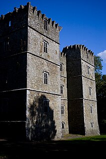
Barntown Castle is about 3 miles (5 km) west of Wexford town on the main Wexford to New Ross road. It is a Tower House in ruins set in the middle of a grazing field. A Georgian mansion has replaced the castle as the residence of the local landowners, currently the Joyce family. The ruins of the castle are used as a cattle shelter. Barntown village and townsland has a Pugin designed Roman Catholic church and a national school. Close by, on the ridge of the hills south of the castle, is a monument to General Clooney famous for his part in the 1798 Rising. This man is referred to as Col. Clooney on a plaque at the ruins of Geneva Barracks, on Waterford Harbour. He also, reputedly, captured a British warship near Duncannon during the 1798 Rebellion. He is buried in St. Mullins.

Riverstown is a small village straddling the border between Counties Tipperary and Offaly on the outskirts of Birr in Ireland. It is mostly within the townland of Ballyloughnane, on the Tipperary side of the river.
Kilanerin or Killinierin is a village in north County Wexford, Ireland, 4 kilometres west of the N11 road, near the village of Inch and approximately 12 kilometres from the town of Gorey.

Clogh is a small rural village in Ireland. Many local residents refer to the village as "Clough", and this is regarded as the proper spelling.

Cullenstown is a townland and small village located on the south coast of County Wexford, in Ireland. A small beach, Cullenstown Strand, is located nearby.
Dunbrody Country House Hotel is an Irish Georgian manor turned-restaurant in County Wexford, owned by Irish chef Kevin Dundon and his wife Catherine. It is located near the village of Arthurstown.

Aghade is a small civil parish, in the barony of Forth, County Carlow, Ireland. It is 3 miles from Tullow and has a notable bridge over the River Slaney. It also has a church, and at one time had a school.

Clara or Clara More is a townland and small clachan consisting of a bridge over the Avonmore River and a number of buildings in County Wicklow in Ireland. The village is situated halfway between Laragh and Rathdrum on the R755 road, and is sometimes referred to as the 'smallest village in Ireland'.

The Nenagh River rises in the Silvermine Mountains in County Tipperary, Ireland. It flows east of Nenagh and into Lough Derg just north of Dromineer.
Sharavogue is a townland in the historical Barony of Clonlisk, County Offaly, Ireland. It is a rural area located around the junction of the N52 road and the R492 between Roscrea and Birr. The Little Brosna River flows under Sharavogue bridge.
The Yellow River is a river in central Ireland, a tributary of the River Boyne.

Carlanstown is a village and townland in County Meath, Ireland. It is located approximately 4 km northeast of the larger town of Kells, County Meath on the N52 road. As of the 2016 census, there were 664 people living in the village.

Ladysbridge, known for census purposes as Knockglass, is a village in County Cork, Ireland. As of the 2016 census, the area had a population of 658 people.

The Ballast Bank, situated in Wexford Harbour, Ireland, is a man made structure, built in 1832.
