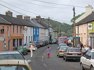
Macroom is a market town in County Cork, Ireland, located in the valley of the River Sullane, halfway between Cork city and Killarney. Its population has grown and receded over the centuries as it went through periods of war, famine and workhouses, forced emigration and intermittent prosperity. The 2011 census gave an urban population of 3,879 people, while the 2016 census recorded 3,765 people.

Union Hall, also Unionhall, is a small fishing village located in County Cork, Ireland, located on the west side of Glandore Harbour. Its nearest neighbour to the west is Castletownshend; to the east, Glandore village. It is approximately 10 kilometres south-east of Skibbereen. As of the 2016 census, 270 people were living in Union Hall.

Shanballymore is a small village in north County Cork, Ireland. It neighbours the towns of Doneraile, Kildorrery and Castletownroche, and is off the main route from Mallow to Mitchelstown. Shanballymore is part of the Cork East Dáil constituency.

Millstreet is a town in north County Cork, Ireland. As of the 2022 census, it had a population of 1,722.

Rosscarbery is a village and census town in County Cork, Ireland. The village is on a shallow estuary, which opens onto Rosscarbery Bay. Rosscarbery is in the Cork South-West constituency, which has three seats.
Tournafulla, or Toornafulla, is a village in the southwest of County Limerick, Ireland. Tournafulla is a long single-street village. It has a Catholic church, a primary school, three pubs, a community hall and a GAA pitch. As of the 2016 census, the village had a population of 144 people.

Carrigtwohill, officially Carrigtohill, is a town in County Cork, Ireland with a population of 5,080 (2016). It is 12 kilometres east of Cork city. It is connected to Cork Suburban Rail and is bypassed by the N25 road. Carrigtwohill is one of the fastest-growing towns in the region, and a hub for pharmaceutical and biotechnology companies. Carrigtwohill is part of the Cork East Dáil constituency.

Ballyvourney is a Gaeltacht village in southwest County Cork, Ireland. It is a civil parish in the barony of Muskerry West, and is also an ecclesiastical parish in the Roman Catholic Diocese of Cloyne. Ballyvourney is part of the Cork North-West Dáil Constituency.

Clonaslee is a village in north County Laois, Ireland, situated in the foothills of the Slieve Bloom Mountains on the R422 Mountmellick to Birr road. Clonaslee is approximately 100 km west of Dublin, and is close to the towns of Portlaoise and Tullamore.

Cúil Aodha, anglicised as Coolea, is a townland and village in the Gaeltacht region of Muskerry in County Cork, Ireland. The area is near the source of the River Sullane in the Derrynasaggart Mountains.

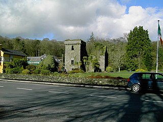
Carrigaphooca Castle is a ruined five storey rectangular tower house situated on a steep-sided rock overlooking the River Sullane. It is located 6 km west of Macroom, County Cork, Ireland, in an area once known as Gleann na n-Dearg. The tower dominates the landscape of Lissacresig (Fairyland) in Clondrohid, and Lower Shanballyshane, in Kilnamartyra. Carrigaphooca is made of sandstone and limestone and was built as a defensive tower by the MacCarthys of Muskerry in the early 15th century.

Farran is a village in County Cork, Ireland, in the parish of Ovens. It lies on the southside of the River Lee. Farran is 12 miles (19 km) west from Cork City on the N22 road.
Cloncollow is a townland in the Parish of Tomregan, Barony of Loughtee Lower, County Cavan, Ireland.
Muskerry West is one of the baronies of Ireland, a historical geographical unit of land. Its chief town is Macroom. It is one of 24 baronies in the county of Cork. It may also be viewed as a half barony because sometime before the 1821 census, it was divided from its other half – Muskerry East. Other neighbouring baronies include Duhallow to the north and the Barony of Carbery East to the south.

Clonmoyle East is a townland within both the civil parish and catholic parish of Aghabullogue, County Cork, Ireland. It is 756.05 acres in size, situate east of Aghabullogue village, and north of Coachford village.

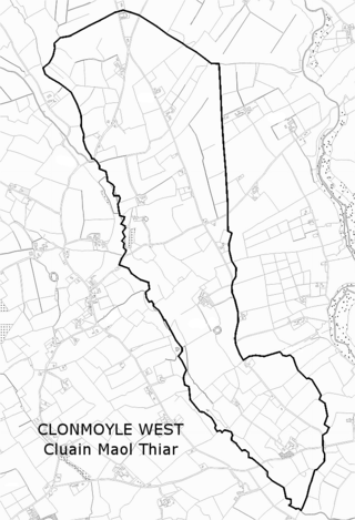
Clonmoyle West is a townland within both the civil parish and catholic parish of Aghabullogue, County Cork, Ireland. It is approximately 776 acres (3.14 km2) in area, situated east of Aghabullogue village, and north-west of Coachford village. It adjoins the townland of Clonmoyle East.

Clontead Beg is a townland within the civil parish of Magourney and Catholic parish of Aghabullogue, County Cork, Ireland. It is approximately 229 acres in size, and east of Coachford village.

Clontead More is a townland in the civil parish of Magourney and historical barony of Muskerry East in County Cork, Ireland. The townland, which is approximately 1.3 square kilometres (0.5 sq mi) in area, had a population of 75 people as of the 2011 census. Overlapping with the nearby village of Coachford, it adjoins the townlands of Clontead Beg to the south and Carrignamuck to the east.
Carrigaphooca Stone Circle is a stone circle and National Monument located in County Cork, Ireland. It is situated 4.4 km (2.7 mi) west of Macroom, immediately east of Carrigaphooca Castle, north of the N22, and near the confluence of the River Sullane and River Foherish. The name means "stone of the púca".

Ladysbridge, known for census purposes as Knockglass, is a village in County Cork, Ireland. As of the 2016 census, the area had a population of 658 people.


