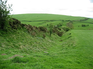
Offa's Dyke is a large linear earthwork that roughly follows the border between England and Wales. The structure is named after Offa, the Anglo-Saxon king of Mercia from AD 757 until 796, who is traditionally believed to have ordered its construction. Although its precise original purpose is debated, it delineated the border between Anglian Mercia and the Welsh kingdom of Powys.

Offa's Dyke Path is a long-distance footpath loosely following the Wales–England border. Officially opened on 10 July 1971, by Lord Hunt, it is one of Britain's National Trails and draws walkers from throughout the world. About 60 miles (97 km) of the 177-mile (285 km) route either follows, or keeps close company with, the remnants of Offa's Dyke, an earthwork traditionally thought to have been constructed in the late 8th century on the orders of King Offa of Mercia.

Hopewell Culture National Historical Park is a United States national historical park with earthworks and burial mounds from the Hopewell culture, indigenous peoples who flourished from about 200 BC to AD 500. The park is composed of six separate sites in Ross County, Ohio, including the former Mound City Group National Monument. The park includes archaeological resources of the Hopewell culture. It is administered by the United States Department of the Interior's National Park Service.

Mounds State Park is a state park near Anderson, Madison County, Indiana featuring Native American heritage, and ten ceremonial mounds built by the prehistoric Adena culture indigenous peoples of eastern North America, and also used centuries later by Hopewell culture inhabitants. It is separate from the similarly named Mounds State Recreation Area. The park receives about 400,000 visitors annually.

The Hill of Uisneach or Ushnagh is a hill and ancient ceremonial site in the barony of Rathconrath in County Westmeath, Ireland. It is a protected national monument. It consists of numerous monuments and earthworks—prehistoric and medieval—including a probable megalithic tomb, burial mounds, enclosures, standing stones, holy wells and a medieval road. Uisneach is near the geographical centre of Ireland, and in Irish mythology it is deemed to be the symbolic and sacred centre of the island. It was said to be the burial place of the mythical Tuatha Dé Danann, and a place of assembly associated with the druids and the festival of Bealtaine.

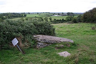
In archaeology, earthworks are artificial changes in land level, typically made from piles of artificially placed or sculpted rocks and soil. Earthworks can themselves be archaeological features, or they can show features beneath the surface.

The Hopeton Earthworks are an Ohio Hopewell culture archaeological site consisting of mounds and earthwork enclosures. It is located on the eastern bank of the Scioto River just north of Chillicothe in Ross County, Ohio, about 1 mile (1.6 km) east of the Mound City Group and Shriver Circle on a terrace of the Scioto River. The site is a detached portion of the Hopewell Culture National Historic Park, along with the Mound City Group, Hopewell Mound Group, Seip Earthworks, Spruce Hill Earthworks and the High Bank Works. The site is open to the public.
The Portsmouth Earthworks are a large prehistoric mound complex constructed by the Ohio Hopewell culture mound builder indigenous peoples of eastern North America. The site was one of the largest earthwork ceremonial centers constructed by the Hopewell and is located at the confluence of the Scioto and Ohio Rivers, in present-day Ohio.

The Wolf Plains Group is a Late Adena culture group of 30 earthworks including 22 conical mounds and nine circular enclosures. The Plains, originally known as Wolf's Plains, located a few miles to the northwest of Athens, is a relatively flat terrace in an area of hilly terrain in southeastern Ohio's Hocking River valley. The terrace was formed by glacial outwash coming down the Hocking River, which became dammed at The Plains and found a new outlet to the northeast, leaving the terrace in place.

Wakefield Castle, Lowe Hill or Lawe Hill was a castle built in the 12th century on a hill on the north side of the River Calder near Wakefield, England. Its name derives from the Anglo Saxon hlaew meaning a mound or cairn, possibly a burial mound or barrow. The mound, situated a quarter mile from the river, was separated from the town by flat swampy land and was seen as a good site for a fortification.

The Peel of Lumphanan, also known as the Peel Ring or Peel Bog of Lumphanan, is a defensive structure dating back to the 13th century. It is located near Lumphanan in Aberdeenshire, north-east Scotland.

Scratchbury Camp is the site of an Iron Age univallate hillfort on Scratchbury Hill, overlooking the Wylye valley about 1 km northeast of the village of Norton Bavant in Wiltshire, England. The fort covers an area of 37 acres (15 ha) and occupies the summit of the hill on the edge of Salisbury Plain, with its four-sided shape largely following the natural contours of the hill.

Poverty Point State Historic Site/Poverty Point National Monument is a prehistoric earthwork constructed by the Poverty Point culture. The Poverty Point site is located in present-day northeastern Louisiana though evidence of the Poverty Point culture extends throughout much of the Southeastern Woodlands. The culture extended 100 miles (160 km) across the Mississippi Delta and south to the Gulf Coast. The Poverty Point site has been designated as a state historic site, U.S. National Monument, a U.S. National Historic Landmark, and UNESCO World Heritage Site. Located in the Southern United States, the site is 15.5 miles (24.9 km) from the current flow of the Mississippi River, and is situated on the edge of Macon Ridge, near the village of Epps in West Carroll Parish, Louisiana.

The Marietta Earthworks is an archaeological site located at the confluence of the Muskingum and Ohio Rivers in Washington County, Ohio, United States. Most of this Hopewellian complex of earthworks is now covered by the modern city of Marietta. Archaeologists have dated the ceremonial site's construction to approximately 100 BCE to 500 CE.

The Aetna Earthworks, also known as the Missaukee Earthworks or Missaukee Mounds, is an archaeological site consisting of a pair of circular earthworks designated 20MA11 and 20MA12 located in Aetna Township, Missaukee County, Michigan. The layout of the site is thought to represent the Midewiwin origin tale of Bear's Journey. It was listed on the National Register of Historic Places in 1973.
The Clonfinlough Stone is a piece of rock art and National Monument located near Kinnitty, County Offaly, Ireland.
Granard Motte is the remains of a motte-and-bailey castle and National Monument in Granard, County Longford, Ireland.

Warbstow Bury is an Iron Age hillfort about 0.5 miles (0.80 km) west of the village of Warbstow, in Cornwall, England. It is a scheduled monument.

The Stubbs Earthworks was a massive Ohio Hopewell culture archaeological site located in Morrow in Warren County, Ohio.

The Shriver Circle Earthworks are an Ohio Hopewell culture archaeological site located in Chillicothe in Ross County, Ohio. At 1,200 feet (370 m) in diameter the site is one of the largest Hopewell circular enclosures in the state of Ohio.
