Clutha Mata-Au River Parkway Group

Last updated

Upper Clutha Valley. Upper Clutha Valley.jpg
Upper Clutha Valley.

The Clutha Mata-Au River Parkway Group, New Zealand, was registered as an Incorporared Society in December 2003 and registered with Charities Servics in 2008[ citation needed ] The Group was set up in response to land development issues along the Clutha River / Mata-Au corridor, [1] much of which has high scenic and recreational values. The project aims to establish a regional river parkway, including a river trail, along the entire 338 km river corridor from Lake Wānaka to the Pacific Ocean.

Contents

Description

The mission statement of the group is: 'To protect and improve the natural, recreational, and cultural values of the Clutha Mata-Au River corridor, from Lake Wānaka to the Pacific, by establishing a Clutha Mata-Au River Parkway, including a Clutha River Trail, with an integrated management body to safeguard the public interest with a long-term vision.'[ citation needed ]

The Parkway Group is working with trail-focused community groups such as the Clutha Gold Trail Trust, [2] and the Upper Clutha Tracks Trust, [3] [4] to create a contiguous trail that is expected to attract tourists, bringing economic benefits to the region and facilitating further river corridor improvements such as native restoration.

The Clutha Mata-Au River is New Zealand's largest and most powerful river. It carves 338 km from the Southern Alps to the Pacific Ocean, traversing the semi-desert interior of Otago known as Central Otago.

The waters of the Clutha Mata-Au are clear turquoise in the upper reaches, a characteristic that results from glacial and snow-melt filtering by upland lakes, especially Lake Wānaka. In global terms this is rare, because glacially fed rivers are normally discoloured by rock flour. The Clutha Mata-Au is also often listed among the world's swiftest rivers.[ citation needed ]

History

Historically, the river has been the focus of intense gold-mining. The Otago gold rush began in 1861, and it was this influx of people that led to the establishment of many of the river towns that still exist today, such as Alexandra, Clyde, and Cromwell.

In 1956, a large hydro-electric dam was commissioned at Roxburgh, flooding the deep-sided Roxburgh Gorge and several well-known rapids, including the Molyneux Falls and the Golden Falls. Another large dam was commissioned at Clyde in 1992, flooding the Cromwell Gorge and the often photographed Cromwell Junction where the silty Kawarau River merged reluctantly with the clear Upper Clutha. The Clyde Dam was highly controversial, having been mistakenly built above an active fault, the River Channel Fault. [5]

The owners of these dams, Contact Energy, [6] announced in February 2009 [7] that they were revisiting former plans for four more large dams on the Clutha Mata-Au. Some people believe that this development would provide jobs and new lakes for recreation, and that the industrialisation of the river valley is an acceptable consequence. However, the Clutha Mata-Au River Parkway Group strongly opposes further damming of the river, as do many people in the river communities. [8] [9] [10] [11] [12] [13]

In October, 2009, the Clutha Mata-Au River Parkway Group [14] facilitated the formation of the Clutha River Forum, [15] [16] an alliance of conservation groups and concerned individuals throughout Otago and New Zealand, who have resolved to work together to prevent further Think Big dams on the Clutha River. Members of the Forum include: Upper Clutha River Guardians, [17] Clutha Mata-Au River Parkway Group, Central Otago Environmental Society (Save Central), [18] Beaumont Residents Group, [19] Lower Clutha River Guardians, Forest & Bird (Dunedin / Central – Lakes). The Forum is campaigning for "Option 5 - NO More Dams". [20]

Related Research Articles

<span class="mw-page-title-main">Otago</span> Region of New Zealand

Otago is a region of New Zealand located in the southern half of the South Island administered by the Otago Regional Council. It has an area of approximately 32,000 square kilometres (12,000 sq mi), making it the country's second largest local government region. Its population was 254,600 in June 2023.

<span class="mw-page-title-main">Alexandra, New Zealand</span> Town in Otago, New Zealand

Alexandra is a town in the Central Otago district of the South Island of New Zealand. It is on the banks of the Clutha River, on State Highway 8, 188 kilometres (117 mi) by road from Dunedin and 33 kilometres (21 mi) south of Cromwell. The nearest towns to Alexandra via state highway 8 are Clyde seven kilometres to the northwest and Roxburgh forty kilometres to the south. State highway 85 also connects Alexandra to Omakau, Lauder, Oturehua, Ranfurly and on to Palmerston on the East Otago coast.

<span class="mw-page-title-main">Clutha River</span> River in the South Island of New Zealand

The Clutha River is the second longest river in New Zealand and the longest in the South Island. It flows south-southeast 338 kilometres (210 mi) through Central and South Otago from Lake Wānaka in the Southern Alps to the Pacific Ocean, 75 kilometres (47 mi) south west of Dunedin. It is the highest volume river in New Zealand, and the swiftest, with a catchment of 21,000 square kilometres (8,100 sq mi), discharging a mean flow of 614 cubic metres per second (21,700 cu ft/s). The river is known for its scenery, gold-rush history, and swift turquoise waters. A river conservation group, the Clutha Mata-Au River Parkway Group, is working to establish a regional river parkway, with a trail, along the entire river corridor.

<span class="mw-page-title-main">Lake Wānaka</span> Lake in Otago, New Zealand

Lake Wānaka is New Zealand's fourth-largest lake and the seat of the town of Wānaka in the Otago region. The lake is 278 meters above sea level, covers 192 km2 (74 sq mi), and is more than 300 m (980 ft) deep.

The Clyde Dam, New Zealand's second-largest hydroelectric dam, is built on the Clutha River / Mata-Au near the town of Clyde. It is owned and operated by Contact Energy.

<span class="mw-page-title-main">Cromwell, New Zealand</span> Town in Otago, New Zealand

Cromwell is a town in Central Otago region of the South Island of New Zealand. Cromwell is located on the shores of Lake Dunstan where the Kawarau river joins Lake Dunstan. Cromwell was established during the Otago gold rush and is now more known as one of the sub regions of the Central Otago wine region. In 2018, the town of Cromwell was home to a population of 5610 people.

<span class="mw-page-title-main">Wānaka</span> Resort town in Otago, New Zealand

Wānaka is a popular ski and summer resort town in the Otago region of the South Island of New Zealand. At the southern end of Lake Wānaka, it is at the start of the Clutha River and is the gateway to Mount Aspiring National Park.

<span class="mw-page-title-main">Central Otago</span> Region in New Zealand

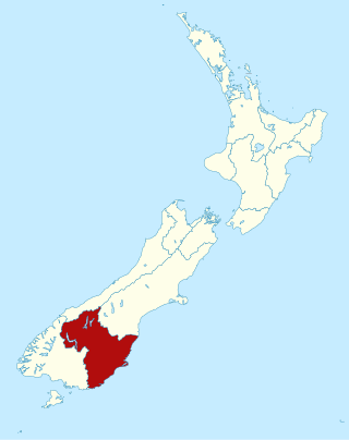
Central Otago is an area located in the inland part of the Otago region in the South Island of New Zealand. The motto for the area is "A World of Difference".

<span class="mw-page-title-main">Kawarau River</span> River in the South Island of New Zealand

The Kawarau River is a river in the South Island of New Zealand. It drains Lake Wakatipu in northwestern Otago via the lake's Frankton Arm. The river flows generally eastwards for about 60 kilometres (37 mi) and passes through the steep Kawarau Gorge until it joins Lake Dunstan near Cromwell. Before the construction of the Clyde High Dam, the Kawarau joined the Clutha River / Mata-Au in a spectacular confluence at Cromwell. The Shotover River enters the Kawarau from the north; the Nevis River enters it from the south. With many rapids and strong currents, the river can be dangerous and has claimed many lives. It is popular for bungy jumping and kayaking.

South Otago lies in the south east of the South Island of New Zealand. As the name suggests, it forms the southernmost part of the geographical region of Otago.

<span class="mw-page-title-main">Cardrona River</span> River in the South Island of New Zealand

The Cardrona River is in Otago in the South Island of New Zealand. It is one of the first tributaries of the Clutha River / Mata-Au, which it meets only 5 kilometres (3 mi) from the latter's origin at the outflow of Lake Wānaka.

<span class="mw-page-title-main">Cromwell Gorge</span> River gorge in New Zealand

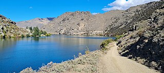
The Cromwell Gorge is a steep gorge cut by the former Clutha River in the Central Otago region of New Zealand's South Island. It winds 19 km (12 mi) between the Dunstan and Cairnmuir Mountains, linking the townships of Cromwell and Clyde. It is one of three substantial river gorges in Central Otago, the others being the Kawarau Gorge to the west of Cromwell, and the Roxburgh Gorge south of Alexandra.

<span class="mw-page-title-main">Clyde, New Zealand</span> Town in Otago, New Zealand

Clyde, formerly Dunstan, is a small town in Central Otago, New Zealand with a population of 1,260 in June 2023. It is located on the Clutha River, between Cromwell and Alexandra.

<span class="mw-page-title-main">Lake Hāwea</span> Lake in Otago Region, New Zealand

Lake Hāwea is New Zealand's ninth largest lake.

<span class="mw-page-title-main">State Highway 8 (New Zealand)</span> Road in New Zealand

State Highway 8 is one of New Zealand's eight national highways. It forms an anticlockwise loop through the southern scenic regions of the Mackenzie Basin and Central Otago, starting and terminating in junctions with State Highway 1. Distances are measured from north to south.

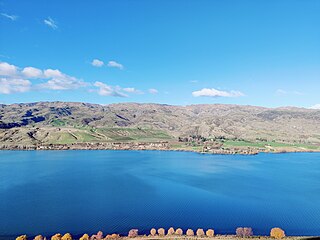
Lowburn is a small settlement in Central Otago, in the South Island of New Zealand. It is located close to the shores of the man-made Lake Dunstan, which was formed by the building of the Clyde Dam. Lowburn lies between the towns of Wānaka and Cromwell.

Clutha County was one of the counties of New Zealand in the South Island. Its first meeting was on 4 January 1877 at the Balclutha courthouse. The offices on the corner of Clyde and Elizabeth Streets in Balclutha were rebuilt in 1934 and demolished in 2009. Clutha District Council began in November 1989 with amalgamation of Balclutha Borough, Clutha County, Lawrence Borough, Tapanui Borough, part of Tuapeka County and Bruce District Council. Bruce District Council had been formed in 1986 from Bruce County, Milton Borough and Kaitangata Borough.

<span class="mw-page-title-main">Southern Lakes (New Zealand)</span>

The Southern Lakes is an unofficial name given to an area of the southern South Island of New Zealand. Despite being an unofficial designation, the term Southern Lakes is sometimes used by organisations such as the New Zealand Meteorological Service and Automobile Association. Though exact definitions vary, the area encompasses parts of western Southland and Central Otago, and is occasionally extended to include the Mackenzie Basin of inland Canterbury, a total of roughly 28,000 to 35,000 square kilometres.

Port Molyneux is a tiny settlement on the coast of South Otago, New Zealand, close to the north-easternmost point of The Catlins. Now home only to farmland, it was a thriving port in the early years of New Zealand's European settlement.

<span class="mw-page-title-main">Dunstan Mountains</span> Mountains in South Island, New Zealand

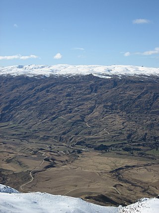
The Dunstan Mountains are a mountain range in Central Otago, in the South Island of New Zealand. The mountains lie on the eastern shore of the man-made Lake Dunstan and overlook the towns of Cromwell to the west, Clyde to the south and Omakau to the east. The highest named peak on the mountain range, a rocky knoll simply called Dunstan, is 1,667 m.

References

  1. "New Zealand at a crossroads". The Boston Globe.
  2. Brown, Diane (17 December 2008). "Walking and biking track would link to others". Otago Daily Times . Retrieved 24 September 2011.
  3. "Riverrun Trail Series". UCTT. Retrieved 5 July 2012.
  4. "Upper Clutha Tracks Trust". Archived from the original on 25 January 2009. Retrieved 21 March 2009.
  5. Trevor Reeves; Judith Wolfe (1990). An Abuse of Power, The Story of the Clyde Dam. Square One Press. ISBN   0-908562-12-8.
  6. "NZ Electricity & Gas Power Company". Contact Energy. 2 January 2012. Archived from the original on 8 February 2013. Retrieved 19 January 2013.
  7. Conway, Glenn (27 February 2009). "Contact revisits plans for 4 dams". Otago Daily Times . Retrieved 24 September 2011.
  8. Conway, Glenn (15 August 2008). "Clutha communities prepare to stop dams". Otago Daily Times . Retrieved 24 September 2011.
  9. Conway, Glenn (25 April 2009). "Beaumont residents against dams". Otago Daily Times . Retrieved 24 September 2011.
  10. Haggart, Matthew (27 February 2009). "Hydro plans 'slap in the face'". Otago Daily Times . Archived from the original on 9 June 2011. Retrieved 24 September 2011.
  11. Lynda Van Kempen (20 April 2009). "River park and trail group attacks dam plans". Otago Daily Times . Retrieved 24 September 2011.
  12. Cannan, Dave (27 April 2009). "Dams' impact causes concern". Otago Daily Times . Retrieved 24 September 2011.
  13. Conway, Glenn (22 August 2008). "District remains opposed to dams". Otago Daily Times . Retrieved 24 September 2011.
  14. "Clutha Mata-Au River Parkway". Cmrp.org.nz. Archived from the original on 4 February 2013. Retrieved 19 January 2013.
  15. "Clutha Forum Launches 'Option 5' Campaign | Scoop News". Scoop.co.nz. 16 October 2009. Retrieved 19 January 2013.
  16. Rush, Molyneux (17 October 2009). "Clutha River Guardian: Clutha Forum Launches 'Option 5'". Cluthariverguardian.blogspot.com. Retrieved 19 January 2013.
  17. "Upper Clutha River Guardians". Ucrg.org.nz. Archived from the original on 5 February 2013. Retrieved 19 January 2013.
  18. "Central Otago Environmental Society - Home". Coes.co.nz. Archived from the original on 5 February 2013. Retrieved 19 January 2013.
  19. "Hands Off Beaumont". Handsoffbeaumont.blogspot.com. Retrieved 19 January 2013.
  20. Rush, Molyneux. "Save The Clutha". Savetheclutha.blogspot.com. Retrieved 19 January 2013.