
Raglan (; is a village and community in Monmouthshire, south-east Wales, United Kingdom. It is located some 9 miles south-west of Monmouth, midway between Monmouth and Abergavenny on the A40 road very near to the junction with the A449 road. It is the location of Raglan Castle, built for William ap Thomas and now maintained by Cadw. The community includes the villages of Llandenny and Pen-y-clawdd. Raglan itself has a population of 1,183.
Pontypool Park is a 150-acre (0.61 km2) park in Pontypool, Torfaen, Wales. The park was formerly the grounds of Pontypool House and was laid out in the closing years of the 17th century for John Hanbury, an ironmaster, who is closely associated with Japanware. The grounds were purchased by the local authority in 1920, while the estate house was leased, and later sold, to the Sisters of the Holy Ghost to become St. Alban's RC High School. The former stables now house the Torfaen Museum. The grounds contain a number of structures including a double ice house, the Folly Tower and the Shell Grotto. The park is entered through the Pontymoile Gates. The gates, the grotto and the stables are all Grade II* listed structures, while the former hall and the ice house are listed Grade II. The park itself is designated at Grade II* on the Cadw/ICOMOS Register of Parks and Gardens of Special Historic Interest in Wales.

Abergavenny Castle is a ruined castle in the market town of Abergavenny, Monmouthshire, Wales, established by the Norman lord Hamelin de Balun c. 1087. It was the site of a massacre of Welsh noblemen in 1175, and was attacked during the early 15th-century Glyndŵr Rising. William Camden, the 16th-century antiquary, said that the castle "has been oftner stain'd with the infamy of treachery, than any other castle in Wales."

Llantilio Crossenny is a small village and much larger former community, now in the community of Whitecastle, in Monmouthshire, south east Wales, in the United Kingdom. It is situated between the two towns of Abergavenny and Monmouth on the B4233 road. The community included Penrhos, and Llanvihangel-Ystern-Llewern.

Llanarth Court is a late-18th-century country house with substantial 19th-century alterations in Llanarth, Monmouthshire, Wales. The court was built for the Jones family of Treowen and was subsequently the home of Ivor Herbert, 1st Baron Treowen, whose family still owns much of the Llanarth estate, although not the court itself. The court is a Grade II* listed building and is now a private hospital. The gardens are included on the Cadw/ICOMOS Register of Parks and Gardens of Special Historic Interest in Wales.

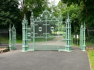
Clytha Park, Clytha, Monmouthshire, is a 19th-century Neoclassical country house, "the finest early nineteenth century Greek Revival house in the county." The wider estate encompasses Monmouthshire's "two outstanding examples of late eighteenth century Gothic", the gates to the park and Clytha Castle. The owners were the Jones family, later Herbert, of Treowen and Llanarth Court. It is a Grade I listed building.

Monmouthshire is a county and principal area of Wales. It borders Torfaen and Newport to the west; Herefordshire and Gloucestershire to the east; and Powys to the north. The largest town is Abergavenny, with the other major towns being Chepstow, Monmouth, and Usk. The county is 850 km2 in extent, with a population of 95,200 as of 2020. The present county was formed under the Local Government (Wales) Act 1994, which came into effect in 1996, and comprises some sixty percent of the historic county. Between 1974 and 1996, the county was known by the ancient title of Gwent, recalling the medieval Welsh kingdom. In his essay on local government in the fifth and final volume of the Gwent County History, Robert McCloy suggests that the governance of "no county in the United Kingdom in the twentieth century was so transformed as that of Monmouthshire".
Monmouthshire is a county of Wales. It borders Torfaen and Newport to the west; Herefordshire and Gloucestershire to the east; and Powys to the north. The largest town is Abergavenny, with the other major towns being Chepstow, Monmouth, and Usk. The county is 850 km2 in extent, with a population of 95,200 as of 2020. The present county was formed under the Local Government (Wales) Act 1994, which came into effect in 1996, and comprises some sixty percent of the historic county. Between 1974 and 1996, the county was known by the ancient title of Gwent, recalling the medieval Welsh kingdom. In his essay on local government in the fifth and final volume of the Gwent County History, Robert McCloy suggests that the governance of "no county in the United Kingdom in the twentieth century was so transformed as that of Monmouthshire".

Coldbrook Park, Llanover, Monmouthshire, Wales, was a major country house and estate. Home successively to the Herberts, the Hanburys and the Halls, the house was demolished in 1954. The estate, which remains privately owned, is listed on the Cadw/ICOMOS Register of Parks and Gardens of Special Historic Interest in Wales.

St Cenedlon's is a parish church in the village of Rockfield, Monmouthshire, Wales. The dedication to St Cenedlon is unusual and the history of the saint is obscure. Some sources suggest that she was a daughter of Brychan king of Brycheiniog while others identify her as the wife of King Arthfael ab Ithel, king of Glywysing. The existing church dates from the Middle Ages but only the tower remains from that period. After the English Reformation, the surrounding area of north Monmouthshire became a refuge for Catholics and Matthew Pritchard (1669-1750), Roman Catholic bishop and Vicar Apostolic of the Western District is buried at the church. By the mid-19th century the church was in ruins and a complete reconstruction was undertaken by the ecclesiastical architects John Pollard Seddon and John Prichard in around 1860. St Cenedlon's is an active parish church in the Diocese of Monmouth. It is designated by Cadw as a Grade II listed building.

Hen Gwrt,, Llantilio Crossenny, Monmouthshire is the site of a thirteenth century manor house and a sixteenth century hunting lodge. Originally constructed for the Bishops of Llandaff, it subsequently came into the possession of the Herberts of Raglan Castle. The bishops constructed a substantial manor house on the site in the thirteenth century, which was moated in the fourteenth. The building was then adapted by the Herberts to create a lodge within their extensive hunting grounds. The lodge continued in use until the slighting of Raglan Castle in the English Civil War.

The Church of St Teilo, Llanarth, Monmouthshire, Wales is a former parish church with its origins in the 15th century. Renovations took place in the 18th, 19th and 20th centuries. It is a Grade II* listed building and is now a redundant church, having closed in 2013.

The Church of St Peter, Bryngwyn, Monmouthshire, Wales is a parish church with its origins in the 13th century. It is a Grade II* listed building.

Llansantffraed is the smallest parish in Monmouthshire, Wales, located four miles to the west of Raglan, north of the A40 between Raglan and Abergavenny. There is no community, only the Llansantffraed Court estate and the church.

Treworgan Manor, Llansoy, Monmouthshire is a country house dating from the early 18th century. Its origins are older, from the 16th century. Long in the possession of the Prichard family, it changed hands a number of times in later centuries and remains a private residence. The house is Grade II* listed, its listing describing it as a "fine Renaissance house". An adjacent barn has its own Grade II Listing.

Great House, Llanarth, Monmouthshire is a farmhouse dating from the late-16th century. Extended in the mid-17th century and little altered thereafter, it is a Grade II* listed building. The detached barn range has its own Grade II listing.

Wern-ddu farmhouse, Llantilio Pertholey, Monmouthshire is a farmhouse of 17th century origins. It has been significantly altered in the 18th, 19th and 20th centuries and the Monmouthshire antiquarian, Sir Joseph Bradney recorded that it had "suffered so much by continual alterations that it shows but little of its antiquity". It is a Grade II* listed building.

Chapel Farmhouse and its attached outbuilding, Llanarth, Monmouthshire is a house dating from the 16th century. Greatly enlarged in the 17th century, it remains a private house. It is a Grade II* listed building.

Perth-hir House, Rockfield, Monmouthshire, Wales, was a major residence of the Herbert family. It stood at a bend of the River Monnow, to the north-west of the village. At its height in the 16th century, the mansion, entered by two drawbridges over a moat, comprised a great hall and a number of secondary structures. Subsequently in the ownership of the Powells, and then the Lorimers, the house became a centre of Catholic recusancy following the English Reformation. By the 19th century, the house had declined to the status of a farmhouse and it was largely demolished in around 1830. Its ruins, and the site which contains considerable remnants of a Tudor garden, are a scheduled monument.
Monmouthshire is a county of Wales. It borders Torfaen and Newport to the west; Herefordshire and Gloucestershire to the east; and Powys to the north. The largest town is Abergavenny, with other large settlements being Chepstow, Monmouth, and Usk. The present county was formed under the Local Government (Wales) Act 1994, which came into effect in 1996. It has an area of 850 km2 (330 sq mi), with a population of 93,200 as of 2021. Monmouthshire comprises some sixty per cent of the historic county, and was known as Gwent between 1974 and 1996.

