
A canyon, gorge or chasm, is a deep cleft between escarpments or cliffs resulting from weathering and the erosive activity of a river over geologic time scales. Rivers have a natural tendency to cut through underlying surfaces, eventually wearing away rock layers as sediments are removed downstream. A river bed will gradually reach a baseline elevation, which is the same elevation as the body of water into which the river drains. The processes of weathering and erosion will form canyons when the river's headwaters and estuary are at significantly different elevations, particularly through regions where softer rock layers are intermingled with harder layers more resistant to weathering.
The Chartreuse Mountains are a mountain range in southeastern France, stretching from the city of Grenoble in the south to the Lac du Bourget in the north. They are part of the French Prealps, which continue as the Bauges to the north and the Vercors to the south.

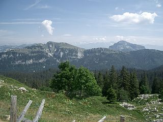
The Vercors Massif is a range in France consisting of rugged plateaus and mountains straddling the départements of Isère and Drôme in the French Prealps. It lies west of the Dauphiné Alps, from which it is separated by the rivers Drac and Isère. The cliffs at the massif's eastern limit face the city of Grenoble.

The Ardèche is a 125-kilometre (78 mi) long river in south-central France, a right-bank tributary of the River Rhône. Its source is in the Massif Central, near the village of Astet. It flows into the Rhône near Pont-Saint-Esprit, north-west of Orange. The river gives its name to the French department of Ardèche.
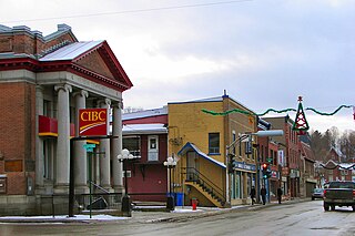
Coaticook is a town on the Coaticook River, located in southeastern Quebec, Canada. It resides in the region of Estrie, which is often referred to colloqually as the Eastern Townships. It is the seat of the Coaticook Regional County Municipality, and its southern border is also the Canada–United States border.

Céüse is a limestone mountain in the Hautes-Alpes département of France near Gap and Sigoyer. The "Pic de Céüse" is at an elevation of 2,016 metres (6,614 ft), and the whole massif is included in the Natura 2000 protected area. The mountain has a distinctive large horseshoe-shaped cliff which contains some of the most extreme sport climbing routes in the world. It is also the site of a ski resort.

The Parc de la Villette is the third-largest park in Paris, 55.5 hectares in area, located at the northeastern edge of the city in the 19th arrondissement. The park houses one of the largest concentrations of cultural venues in Paris, including the Cité des Sciences et de l'Industrie, three major concert venues, and the prestigious Conservatoire de Paris.

The Hautes-Gorges-de-la-Rivière-Malbaie National Park is a provincial park in the Charlevoix region of Quebec, Canada. Centring on the Malbaie River Gorge, it is the centrepiece of the UNESCO Charlevoix biosphere reserve. It is administered by the Société des établissements de plein air du Québec (Sépaq). The park can be reached via a local road, 30 kilometers (19 mi) northwards from Route 138 in Saint-Aimé-des-Lacs.
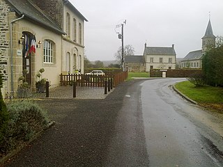
La Bellière is a commune in the Orne department in northwestern France.

Anticosti National Park is a provincial park of Quebec, located in the Gulf of St. Lawrence. It consists of 3 non-contiguous areas totalling 572 square kilometres (221 sq mi) of land in the centre of Anticosti Island. Portions of the park are within Anticosti World Heritage Site, established by UNESCO in 2023.
Mont-Saint-Bruno Provincial Park is a small national park of Quebec located near the municipality of Saint-Bruno-de-Montarville, 15 kilometres (9.3 mi) to the east of Montréal on the south shore of the Saint Lawrence River. The park, with an area of 8.84 square kilometres (3.41 sq mi), notably includes Mont Saint-Bruno, one of the Monteregian Hills which peaks at 218 metres (715 ft). The mountain is shared with the Ski Mont Saint-Bruno ski resort, a quarry and a small Canadian Forces training camp. Despite its relatively small size, the mountain is known for its rich fauna and flora. Situated at the heart of the old signory of Montarville, its many lakes have permitted the construction and exploitation of many water mills, contributing to the region's economical success. A building from one of those mills, the "Vieux Moulin", still stands to this day and is used as a rest area for skiers and hikers in different seasons.

The Vercors Regional Natural Park is a protected area of forested mountains in the Rhône-Alpes region of southeastern France.

The Grande halle de la Villette, formerly a slaughterhouse and now a cultural center, is located in Paris, France. It is situated on Place de la Fontaine aux Lions within the Parc de la Villette, in the 19th arrondissement. While the Grande Halle is within Paris' main abattoir district, the historical building now serves as a venue for trade fairs, exhibitions, music festivals, and open-air cinema.

The Montagne des Érables, also known as Mont des Érables, is a massif located in the Charlevoix-Est regional county municipality in the Charlevoix region of Quebec, Canada. It lies in the Hautes-Gorges-de-la-Rivière-Malbaie National Park and is home to l'Acropole des Draveurs, a popular hike in the province. It is accessible via the entrances to the park, the main one being located in Saint-Aimé-des-Lacs.

Mount Pinacle is a mountain located in Coaticook, Quebec Canada. The mountain has five hiking trails of varying difficulty, covering approximately 7 kilometres (4.3 mi), that visitors can explore with the purchase of an admission ticket. Experienced rock climbers may scale the face of the hill starting from Lake Lyster. The mountain is exploited for its abundance of maples, with a sugar bush running along a portion of its trails.
Miconia revolutifolia is a rare tree from Haiti, specifically in Sud. It is endemic to the Morne Formon-Pic Macaya region of the Massif de la Hotte mountain range. Along with the other species of Miconia from the area it is called "macrio", or "bwa pijon" in Haitian Creole.

Mount Hereford is a mountain located in Coaticook Regional County Municipality, Estrie, Quebec, Canada. It rises to 864 metres (2,835 ft).
A regional park, in Quebec, is an area designated by a regional county municipality (MRC) or equivalent territory for the purposes of recreation and of nature conservation.

