
Mormon Lake is a shallow, intermittent lake located in northern Arizona in Pleasant Valley. With an average depth of only 10 ft (3.0 m), the surface area of the lake is extremely volatile and fluctuates seasonally. When full, the lake has a surface area of about 12 square miles (31 km2), making it the largest natural lake in Arizona. In particularly dry times, the lake has been known to dry up, leaving behind a remnant marsh.

Knoll Lake is part of the Blue Ridge Ranger District of the Coconino National Forest. It gets its name from a rocky island located in the middle of the lake. Knoll Lake is located in Leonard Canyon, Arizona, along the Mogollon Rim. This 75-acre (30 ha) lake is located at 7,340 feet (2,240 m) elevation and is closed to visitors in the winter months. Bald eagles may be seen during the winter months if the roads are open late into the season. The facilities are maintained by Coconino National Forest division of the USDA Forest Service.
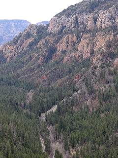
Oak Creek Canyon is a river gorge located in northern Arizona between the cities of Flagstaff and Sedona. The canyon is often described as a smaller cousin of the Grand Canyon because of its scenic beauty. State Route 89A enters the canyon on its north end via a series of hairpin turns before traversing the bottom of the canyon for about 13 miles (21 km) until the highway enters the town of Sedona.

The West Clear Creek Wilderness is a 15,238-acre wilderness area in the U.S. state of Arizona. West Clear Creek is formed by the junction of Willow Creek and Clover Creek in the Mogollon Rim, which is part of the Colorado Plateau; the Mogollon Rim is the major part of the Arizona transition zone at the southwest of the Colorado Plateau of Utah-Colorado, Arizona-New Mexico. Located east of Camp Verde, the area is part of Coconino National Forest. Common activities in West Clear Creek are swimming, camping, backpacking, hunting, fishing, and hiking. A variety of plants and animals can be found year-round, along with extremely cold water.

Alamo Lake State Park is a state park of Arizona, USA, centered on Alamo Lake, a flood control and recreational reservoir. The park is located in western Arizona about 38 miles (61 km) north of Wenden. It is accessed via a paved two-lane road off either U.S. Route 60 to the south or U.S. Route 93 to the east. Owing to its remoteness, the park is often considered one of the "best kept secrets" of the state park system.

Lake Mary may refer to one of two reservoirs in northern Arizona southeast of Flagstaff. The name may also be used to refer to the two lakes as a whole. The pair of lakes impound the intermittent Walnut Creek upstream from Walnut Canyon. Recreational facilities at both lakes are maintained under the authority of the Coconino National Forest.

This is a list of the National Register of Historic Places listings in Coconino County, Arizona.

Bartlett Lake is a reservoir that was formed by the damming of the Verde River in the U.S. state of Arizona. It is downstream and to the south of Horseshoe Reservoir. Constructed in 1936–39 by the Salt River Project, the Bartlett Dam and reservoir were named for Bill Bartlett, a government surveyor. Bartlett Lake was the first reservoir built on the Verde River.

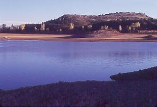
Ashurst Lake is a small lake located on the Anderson Mesa 20 miles (32 km) southeast of Flagstaff. It is one of the few natural lakes in the state of Arizona, the bulk of which reside in the area.
Becker Lake is a reservoir managed as a trophy trout lake. Located near Springerville, Arizona, Becker Lake is part of the 622-acre (252 ha) Becker Lake Wildlife Area. Built around the year 1880, it is one of the oldest reservoirs in the White Mountains. The Arizona Game and Fish Department acquired the lake and property around it in 1973. The lake is located at 6,910 feet (2,110 m).

Blue Ridge Reservoir is located in the Mogollon Rim area of the state of Arizona. Clints Well, Arizona. Blue Ridge Reservoir is one of the more scenic reservoirs in the area, with trees going down to the water line. The facilities are maintained by Coconino National Forest division of the USDA Forest Service.

East Clear Creek is located in the Mogollon Rim area of the state of Arizona. The closest town Winslow is 45 miles (72 km) away.

The East Verde River is a tributary of the Verde River in the U.S. state of Arizona. Beginning on the Mogollon Rim near Washington Park, it flows generally southwest through Gila County and the Tonto National Forest northeast of Phoenix. Near the middle of its course, it passes to within about 5 miles (8 km) of Payson, which is southeast of the river. The East Verde River flows through parts of the Mazatzal Wilderness west of Payson.
Cataract Lake is a lake in Coconino County which is located near Williams in North Central Arizona.
The Lyman Reservoir is the largest lake in the region. Lyman Lake State Park, is located in and administered by the Apache-Sitgreaves National Forest, attracts anglers, as well as campers and water skiers year-round.
Kinnikinick Lake is located 38 mi (61 km) south of Flagstaff in North Central Arizona within the Coconino National Forest. Prairies of juniper surround the lake and typically abound with pronghorn. Bald eagles are often seen during the fall and winter months. The facilities are maintained under the authority of the Coconino National Forest.
Long Lake is located in the Mogollon Rim area of the state of Arizona. It is located 75 miles (121 km) southeast of Flagstaff. The facilities are maintained by Coconino National Forest division of the USDA Forest Service. It is named after a legend of a long serpent type creature that was reportedly seen by ranchers as they herd cattle near the lake.
Soldiers Annex Lake is located 75 miles (121 km) southeast of Flagstaff in the state of Arizona. Long Lake is the main lake of the area. The facilities are maintained by Coconino National Forest division of the USDA Forest Service.
Soldiers Lake is located 75 miles (121 km) southeast of Flagstaff in the state of Arizona. The facilities are maintained by Coconino National Forest division of the USDA Forest Service.
