Coesfelder Berg

Last updated
Gerleve Abbey on the Coesfelder Berg Abtei Gerleve Fruhling.jpg
Gerleve Abbey on the Coesfelder Berg
The Dreilindenhohe with a view over the area around Coesfeld Dreilindenhohe Coesfeld (09107).jpg
The Dreilindenhöhe with a view over the area around Coesfeld

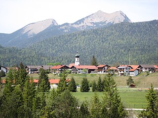
The Coesfelder Berg (152 m) is the westernmost top in the Coesfeld-Darup Hills, a range that is the southwest continuation of the Baumberge hills in the Münsterland in North Germany.

Baumberge mountain range

The Baumberge are the highest hills in the natural regions of Münsterland and Kernmünsterland with a maximum height of 187.6 m above sea level (NHN). They are located between Münster and Coesfeld, which is itself close to the southwest edge of the Baumberge.

Germany Federal parliamentary republic in central-western Europe

Germany, officially the Federal Republic of Germany, is a country in Central and Western Europe, lying between the Baltic and North Seas to the north, and the Alps to the south. It borders Denmark to the north, Poland and the Czech Republic to the east, Austria and Switzerland to the south, France to the southwest, and Luxembourg, Belgium and the Netherlands to the west.

The hill, which is east of the town of Coesfeld (Coesfeld county, North Rhine-Westphalia) is a wide ridge that rises between the streams of the Berkel and the Honigbach, descends towards the west relatively steeply from around 140 m above  sea level (NN) to just under 80 m above  sea level (NN) in the borough of Coesfeld. It is the hausberg for the town.

Coesfeld Place in North Rhine-Westphalia, Germany

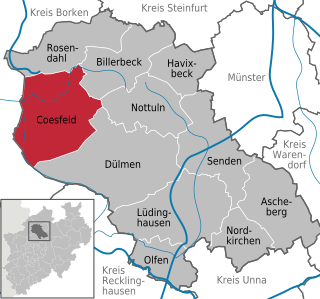
Coesfeld is the capital of the district of Coesfeld in the German state of North Rhine-Westphalia.

North Rhine-Westphalia State in Germany

North Rhine-Westphalia is a state of Germany.

Berkel river

The Berkel is a river in the Netherlands and Germany. It is a right tributary of the River IJssel.

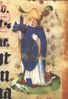
From the Ludgerirast, the highest point of the hill, there are good views thanks of large parts of the western Münsterland thanks to the treeless summit. It is here that, according to Ludgerus (Ludger or Liudger), the first Bishop of Münster paused whilst out walking and blessed the Münsterland on the evening before his death in Billerbeck. [1] The Dreilindenhöhe, with the three lime trees (Tilia europaea that give it the name [2] ) and a viewing point on the hillside above the town of Coesfeld.

Billerbeck Place in North Rhine-Westphalia, Germany

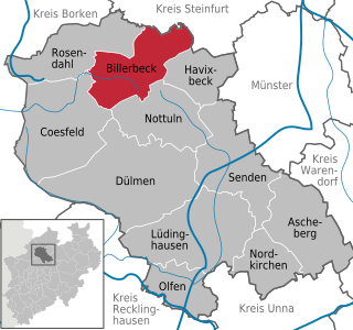
Billerbeck is a municipality in the district of Coesfeld in North Rhine-Westphalia in Germany.

In a scenic side valley south of the Ludgerirast, at a height of 125 metres, is the Benedictine abbey of Gerleve. According to legend, St. Liudger blessed the Bishopric of Münster, that he had founded, from the highest point of the hill on the evening before his death. This is commemorated by a monument erected in 1934 by Brother Dominikus Zwernemann (1901-1983) of Gerleve Abbey.

Gerleve Abbey abbey

Gerleve Abbey is a monastery of the Benedictine Order situated between Coesfeld and Billerbeck in Westphalia, in Germany.

Coordinates: 51°56′51″N7°12′40″E / 51.94750°N 7.21111°E / 51.94750; 7.21111

Geographic coordinate system Coordinate system

A geographic coordinate system is a coordinate system that enables every location on Earth to be specified by a set of numbers, letters or symbols. The coordinates are often chosen such that one of the numbers represents a vertical position and two or three of the numbers represent a horizontal position; alternatively, a geographic position may be expressed in a combined three-dimensional Cartesian vector. A common choice of coordinates is latitude, longitude and elevation. To specify a location on a plane requires a map projection.

Related Research Articles

Münster (region) Regierungsbezirk in North Rhine-Westphalia, Germany

Münster is one of the five Regierungsbezirke of North Rhine-Westphalia, Germany, located in the north of the state, and named after the capital city of Münster. It includes the area which in medieval times was known as the Dreingau.

Dülmen Place in North Rhine-Westphalia, Germany

Dülmen is a town in the district of Coesfeld, North Rhine-Westphalia, Germany.

Ludger Bishop of Munster

Saint Ludger was a missionary among the Frisians and Saxons, founder of Werden Abbey and first Bishop of Münster in Westphalia.

Krün Place in Bavaria, Germany

Krün is a municipality in the Upper Bavarian district of Garmisch-Partenkirchen. It belongs with Garmisch-Partenkirchen as district capital and cultural center as well as other municipalities to the region Werdenfelser Land. A few kilometers south runs the German-Austrian border.

The Hainleite is a Muschelkalk ridge of hills up to 463.2 m above sea level (NN) in northern Thuringia, Germany.

Arnsberg Forest Nature Park nature park in North Rhine-Westphalia, Germany

The Arnsberg Forest Nature Park is a nature park in the districts of Hochsauerlandkreis and Soest within the administrictive region of Arnsberg in the German state of North Rhine-Westphalia. The park has an area of 482 km² and its wooded hills are up to 581.5 m above sea level (NN).

Wittekindsberg mountain

The Wittekindsberg is a hill, 281.48 m above sea level (NN), which forms the easternmost peak of the Wiehen Hills and is also the western guardian of the Weser gorge, the Porta Westfalica, in North Rhine-Westphalia (Germany).

Damme Hills mountain range

The Damme Hills are a high, wooded ridge, up to 146 m above sea level (NN), in the Oldenburg Münsterland in the southern part of the district of Vechta, in western Lower Saxony, Germany.

Homburg Forest mountain range

The Homburg Forest also known as the Homburg Hills is an area of upland up to 406.1 m above sea level (NN) in the north German state of Lower Saxony.

Beckum Hills mountain range

The Beckum Hills, named after the town of Beckum, are a range of low hills, up to 174.4 m above sea level (NN), in the region of Münsterland in the German state of North Rhine-Westphalia (Germany). Along with the Baumberge and its foothills and the Haltern Hills they are among the few prominent elevations in the otherwise gently rolling Münsterland, the River Werse passes the ridge at 100 m to the east and the Lippe passing it at a height of 60 m near Hamm-Uentrop at some distance away from their highest point.

Ardey Hills range of hills in North Rhine-Westphalia, Germany

The Ardey Hills are a range of wooded hills, up to 273.8 m above sea level (NN), in the territory of the city of Dortmund and the districts of Ennepe-Ruhr-Kreis and Unna in the German state of North Rhine-Westphalia. The hills form part of the eastern Rhenish Massif and, to a lesser extent, to the Berg-Mark Hills.

Westerberg (Baumberge) mountain in Germany

The Westerberg, also called the Westerather Berg, is, at 187.6 m above sea level (NN), the highest elevation in the Baumberge hills and the German region of Münsterland. It is located in this small range of hills between the three villages of Billerbeck, Havixbeck, and Nottuln.

Dörenberg mountain

The Dörenberg is a hill, 331.2 m above sea level (NN), in the Teutoburg Forest in the district of Osnabrück, in the German state of Lower Saxony.

Signalberg (Damme) mountain

The Signalberg is, at 146 m above sea level (NN), the highest elevation in the Damme Hills and Oldenburg Münsterland. It rises in the district of Vechta in the north German state of Lower Saxony. The name means "beacon hill".

Kermeter ridge in the Eifel National Park, Germany

The Kermeter is an upland region, up to 527.8 m above sea level (NN), which is part of the North Eifel in the districts of Aachen, Düren and Euskirchen in the southwestern part of the state of North Rhine-Westphalia in Germany.

Ackeburg castle

The Ackeburg, also called the Ackenburg, in the Harz Mountains of central Germany, is the site of a high medieval hill castle, 333.2 m above sea level (NN), in the borough of Falkenstein/Harz in Harz district in the state of Saxony-Anhalt. It was first mentioned in 1216 and was abandoned or destroyed in 1400. There was also a village associated with it, known as Akkeburg.

Teutoburg Forest / Egge Hills Nature Park nature park in North Rhine-Westphalia, Germany

The Teutoburg Forest / Egge Hills Nature Park is a nature park founded in 1965 in the northeast of the German state of North Rhine-Westphalia. After being expanded in 2008, the nature park in the southern Teutoburg Forest and Egge Hills has an area of 2,711 km2, making it the largest in the state and the sixth largest in Germany.

Westerbecker Berg mountain

The Westerbecker Berg is a forested hill in the Teutoburg Forest and, at 236 m above sea level (NHN), the highest point in Tecklenburg Land, the county of Steinfurt and the administrative region of Münster in the German state of North Rhine-Westphalia.

References

  1. Michael Bönte in Kirche+Leben dated 30 March 2005: "Mutig sein" -Missionarische Gedanken bei Ludgeri-Rast , online at kirchensite.de
  2. GIS portal of the county of Coesfeld, is a natural monument with the designation CO 02