
Andrew Geddes Bain, was a South African geologist, road engineer, palaeontologist and explorer.

The Western Cape is a province of South Africa, situated on the south-western coast of the country. It is the fourth largest of the nine provinces with an area of 129,449 square kilometres (49,981 sq mi), and the third most populous, with an estimated 6.6 million inhabitants in 2018. About two-thirds of these inhabitants live in the metropolitan area of Cape Town, which is also the provincial capital. The Western Cape was created in 1994 from part of the former Cape Province, The two largest cities are Cape Town and George

The N1 is a national route in South Africa that runs from Cape Town through Bloemfontein, Johannesburg, Pretoria and Polokwane to Beit Bridge on the border with Zimbabwe. It forms the first section of the famed Cape to Cairo Road.

The Karoo is a semi desert natural region of South Africa. No exact definition of what constitutes the Karoo is available, so its extent is also not precisely defined. The Karoo is partly defined by its topography, geology and climate, and above all, its low rainfall, arid air, cloudless skies, and extremes of heat and cold. The Karoo also hosted a well-preserved ecosystem hundreds of million years ago which is now represented by many fossils.

The Swartberg mountains are a mountain range in the Western Cape province of South Africa. It is composed of two main mountain chains running roughly east–west along the northern edge of the semi-arid Little Karoo. To the north of the range lies the other large semi-arid area in South Africa, the Great Karoo. Most of the Swartberg Mountains are above 2000 m high, making them the tallest mountains in the Western Cape. It is also one of the longest, spanning some 230 km from south of Laingsburg in the west to between Willowmore and Uniondale in the east. Geologically, these mountains are part of the Cape Fold Belt.
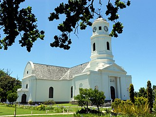
George is the second largest city in the Western Cape province of South Africa. The city is a popular holiday and conference centre and the administrative and commercial hub and the capital city of the Garden Route.

The N12 is a national route in South Africa which runs from George through Beaufort West, Kimberley, Klerksdorp and Johannesburg to eMalahleni.

Nature's Valley is a holiday resort and small village on the Garden Route along the southern Cape coast of South Africa. Nature's Valley lies between the Salt River, the foothills of the Tsitsikamma Mountains, the Indian Ocean and the Groot River lagoon. Nature's Valley has a balmy climate and is surrounded by the de Vasselot Nature Reserve which is part of the Tsitsikamma Park, and in turn part of the Garden Route National Park.
The Route nationale 5, or RN 5, is a trunk road (nationale) in France now connecting Dijon with the frontier of Switzerland. It is also numbered the European route E21.
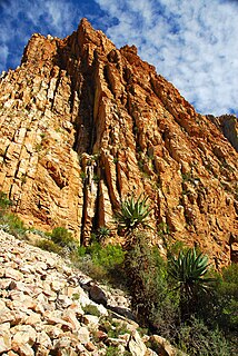
The Swartberg Pass on the R328 run through the Swartberg mountain range which runs roughly east–west along the northern edge of the semi-arid area called the Little Karoo in the Western Cape province of South Africa. It's to only road access to Gamkaskloof.

The four Hex River Tunnels consist of a twin tunnel of 0.5 kilometres and three single tunnels of 1.1 kilometres, 1.2 kilometres and 13.5 kilometres, on the Hexton railway route between De Doorns and Kleinstraat through the Hex River Mountains of the Western Cape Province, South Africa. The line, which connects De Doorns in the Hex River valley with Touws River in the Great Karoo, is part of the main rail route between Cape Town and Johannesburg. Of the 30 kilometres of track, 16.8 kilometres are underground. Construction of the line eliminated the bottleneck of the Hex River rail pass.
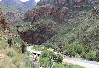
Meiringspoort is a South African mountain pass on the N12 national road, where it crosses the Swartberg mountain range.
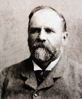
Thomas Charles John Bain was a South African road engineer. As a prolific road building pioneer, Bain was responsible for the planning and construction of more than 900 km of roads and mountain passes, many of them still in use today, over a career spanning from 1848 until 1888. These passes through the mountain ranges between the thin coastal plain and the interior of the former Cape Colony in South Africa, played a major role in opening up the vast hinterland of South Africa.

Grootrivier Pass, is situated in the Western Cape province of South Africa on the R102 regional road. The Grootrivier is one of various mountain streams that over millions of years have cut through the coastal plateau towards the sea.

Bainskloof Pass is a mountain pass on the R301 regional road between Wellington and Ceres in the Western Cape province of South Africa. The 18 kilometres (11 mi) pass, opened in 1854, was constructed by road engineer Andrew Geddes Bain with the use of convict labour. Originally built for horse-drawn traffic, the pass was later tarred.

Du Toitskloof Pass is situated in the Western Cape province of South Africa, on the Regional road R101 between Paarl and Worcester. It was initially an animal track where a road was built around the time of World War II.
Ecca Pass, is situated in the Eastern Cape province of South Africa, on the regional road R67, between Grahamstown and Fort Beaufort. It was the first pass built by Andrew Geddes Bain as part of the Queen's Road. Bain named the heights and the pass after the Ecca River, a Fish River tributary, which is believed to mean "salty" or "brackish" in the local Khoikhoi language.

Wolseley is a small town in the upper Breede River Valley region of the Western Cape province of South Africa. In the 2001 Census it had a population of 12,130 people. It is located 90 kilometres (60 mi) northeast of Cape Town, in the Land van Waveren valley between the Waterval Mountains to the west and the Witzenberg Mountains to the east.

Roodezand Pass was constructed to allow access eastward from Cape Town across the Obiqua Mountains into the valley where the present-day town of Tulbagh is located. The original pass was followed by the development of improved routes, all in the same vicinity and all bearing the same name.

Seven Passes Road is the oldest mountain pass between George and Knysna in Western Cape, South Africa. The pass was built by Thomas Charles John Bain and completed in 1883 just south of the Outeniqua Mountains.
