Related Research Articles

Erode District is one of the 38 districts in the state of Tamil Nadu. It was the largest district by area in the state before the formation of Tirupur District in 2009. The headquarters of the district is Erode. It is divided into two revenue divisions, Erode and Gobichettipalayam, and is further subdivided into 10 taluks. Erode District, then known as, was a part of Coimbatore District before its division into two on 17 September 1979. It covers an area of 5,722 square kilometres (2,209 sq mi), and as of 2011, had a population of 2,251,744.

Kongu Nadu is a region comprising the western part of state of Tamil Nadu in India. It is bounded by the regions of Tondai Nadu on the east, on the south-east by Chola Nadu and on the south by Pandya Nadu.

Coimbatore district is one of the 38 districts in the Indian state of Tamil Nadu. Coimbatore is the administrative headquarters of the district. It is one of the most industrialized districts and a major textile, industrial, commercial, educational, information technology, healthcare and manufacturing hub of Tamil Nadu. The region is bounded by Tiruppur district in the east, Nilgiris district in the north, Erode district in the north-east, Palakkad district, Idukki district and small parts of Thrissur district of neighboring state of Kerala in the west and south respectively. As of 2011, Coimbatore district had a population of 3,458,045 with a sex-ratio of 1,000 and literacy rate of 84%.
Virudhunagar District is a district of Tamil Nadu state in south India. Virudhunagar is the district headquarters and the largest town in Virudhunagar district. Virudhunagar district was formed by the separation of Old Ramanathapuram District in 1987 into Ramanathapuram District, Sivagangai District and the west part as Virudhunagar District. Virudhunagar District was formerly called Karmavirer Kamarajar District. As of 2011, Virudhunagar district had a population of 1,942,288 with a sex-ratio of 1,007 females for every 1,000 males.

Dharapuram is a town in Tirupur district in the Indian state of Tamil Nadu. Dharapuram is one of the oldest towns in Tamil Nadu and was the capital of Kongu Nadu under the Cheras, Western Ganga Dynasty and later Kongu Cholas, at which time it was known as Vanchipuri. Amaravathi River flows through the town. As of 2011, the town had a population of 67,007. Dharapuram Municipality is promoted 1st grade municipality on 6 May 1983 Dharapuram was Part of Coimbatore district in the beginning and later it moves to Erode district up to 2009. Dharapuram Town is situated along the banks of River Amaravathi, located in between 10 degree 45 minutes northern latitude and 77 degree 31 minutes eastern latitude with an extent of 7.02 km2. It is a small agricultural marketing centre for a large rural hinterland in the Tirupur District. The town is 47 km towards of the District Headquarters Tirupur, 75 km towards the Erode and 72 km towards the industrial town Coimbatore. The nearest airport is Coimbatore International Airport located 70 km from Dharapuram. Dharapuram was the capital of Noyyal South District before the formation of Coimbatore District.

The Coimbatore Medical College is a state government-run medical college recognized by the Medical Council of India. It is located in the city of Coimbatore, in Tamil Nadu, India. The hospital attached to the college is located near the railway station and harbours departments like Gastroenterology.

Tamil Nadu has the second-largest economy in India. Over 60% of the state is urbanized, accounting for 10.6% of the urban population in the country, while only comprising 6% of India's total population. Services contributes to 45% of the economic activity in the state, followed by manufacturing at 34% and agriculture at 21%. Government is the major investor in the state, with 52% of total investments, followed by private Indian investors at 29.9% and foreign private investors at 14.9%. It has been ranked as the first most economically free state in India by the Economic Freedom Rankings for the States of India.

Tiruppur District is one of the 38 districts of the Indian state of Tamil Nadu, formed in 22 February 2009. Dharapuram was the Largest Taluk By Area In Tiruppur District. The district is well-developed and industrialized. The Tiruppur banian industry, the cotton market,kangeyam bull and the famous uthukkuli butter, among other things, provide for a vibrant economy. The city of Tiruppur is the administrative headquarters for the district. As of 2011, the district had a population of 2,479,052 with a sex-ratio of 989 females for every 1,000 males.
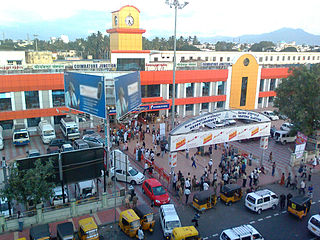
Coimbatore Junction, also known as Coimbatore Main Junction, is the primary railway station serving Coimbatore city.

Coimbatore District was one of the districts of the erstwhile Madras Presidency of British India. It covered the areas of the present-day districts of Coimbatore, Erode and Tirupur and the Kollegal taluk of present-day Karnataka. It covered a total area of 20,400 square kilometres (7,860 sq mi) and was sub-divided into 10 taluks. The administrative headquarters was Coimbatore city. Most of Coimbatore's inhabitants were Tamil-speaking but there were also large numbers of Malayalam, Telugu and Kannada speaking people.
Sulur taluk is a taluk of Coimbatore district of the Indian state of Tamil Nadu. The headquarters is the town of Sulur. This revenue block consist of 41 revenue villages.
Valparai taluk is a taluk of Coimbatore district of the Indian state of Tamil Nadu. The headquarters is the town of Valparai. Anaimalai Hills Village is the only revenue villages under this revenue.
Pollachi district is a proposed district from Coimbatore district of Tamil Nadu, India. According to 2011 Census of India, the estimated area of Pollachi Division is 2,089 Sq.km.The pollachi Division has Two Taluks Namely Pollachi Taluk and Valparai Taluk. According to 2011 Census, the Estimated Population of Pollachi Division is 6,57,876. Our Chief Minister Edappady k.Palanisamy has declared 3 Districts to be formed in 2020-2021. They are Pollachi,Gobichettipalayam and Kumbakonam.
The Coimbatore Municipal Corporation is the civic body that governs the city of Coimbatore in the Indian state of Tamil Nadu. The corporation is Tamil Nadu's second largest after the Greater Chennai Corporation.
Coimbatore has a well-developed transport infrastructure. The city and its suburbs is traversed using its road networks. Coimbatore is well connected by Road, Rail and Air with most cities and towns in India except through waterways. The city has fairly better transport infrastructure, though road infrastructures are not well maintained and developed according to the growing needs of transport, making traffic congestion a major problem in the city. A comprehensive transport development plan is made part of Coimbatore Masterplan as part to ease many of traffic problems.

Coimbatore is the second largest city in the Indian state of Tamil Nadu. It is situated in the western corner of Tamil Nadu, a short distance from the border with the neighbouring state of Kerala, and is surrounded by the Western Ghats on all sides.

Mettupalayam railway station is a train station located in Mettupalayam, a suburb of Coimbatore District in Tamil Nadu, India. Its railway code is MTP. It is one of the important railway stations located in the Coimbatore District, because the Nilgiri Mountain Railway starts from here. The station is served by the Salem Division of Southern Railway zone of Indian Railways.
Salem division is one among the six divisions of Southern Railway zone. Its Headquarters is at Salem, Tamil Nadu.
Coimbatore or Kovai is a major city in the Indian state of Tamil Nadu. It is the second largest city and urban agglomeration in the state after Chennai and the sixteenth largest urban agglomeration in India. It is administered by the Coimbatore Municipal Corporation and is the administrative capital of Coimbatore district. It is one of the fastest growing tier-II cities in India and a major textile, industrial, commercial, educational, information technology, healthcare and manufacturing hub of Tamil Nadu. It is often referred to as the "Manchester of South India" due to its cotton production and textile industries.
References
- "Map of Revenue divisions of Coimbatore district". Archived from the original on 15 April 2012.
| District Headquarters |  | |
|---|---|---|
| Country | ||
| State | ||
| Region | ||
| Taluks | ||
| Municipal Corporations | ||
| Municipalities | ||
| Rivers | ||
| History | ||
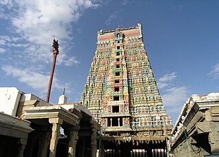
| Places of interest |
| |
| Universities | ||
| This Coimbatore district location article is a stub. You can help Wikipedia by expanding it. |